National Register of Historic Places listings in Pushmataha County, Oklahoma
This is a list of the National Register of Historic Places listings in Pushmataha County, Oklahoma.

Location of Pushmataha County in Oklahoma
This is intended to be a complete list of the properties on the National Register of Historic Places in Pushmataha County, Oklahoma, United States. The locations of National Register properties for which the latitude and longitude coordinates are included below, may be seen in a map.[1]
There are 8 properties listed on the National Register in the county.
- This National Park Service list is complete through NPS recent listings posted January 29, 2021.[2]
Current listings
| [3] | Name on the Register[4] | Image | Date listed[5] | Location | City or town | Description |
|---|---|---|---|---|---|---|
| 1 | Albion State Bank | December 11, 1979 (#79002024) |
Off U.S. Route 271 34°39′48″N 95°05′59″W |
Albion | Demolished | |
| 2 | Antlers Frisco Depot and Antlers Spring | 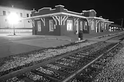 Antlers Frisco Depot and Antlers Spring |
June 27, 1980 (#80003298) |
119 W. Main St. 34°13′51″N 95°37′17″W |
Antlers | |
| 3 | James Martin Baggs Log Barn | September 8, 2015 (#15000579) |
W. side of Cty. Rd. N4480 34°24′11″N 95°03′52″W |
Pickens | geocoordinates are approximate. | |
| 4 | Clayton High School-Auditorium | 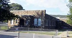 Clayton High School-Auditorium |
September 8, 1988 (#88001418) |
W. Pine St. 34°35′22″N 95°21′16″W |
Clayton | |
| 5 | Fewell School | September 8, 1988 (#88001419) |
Off State Highway 144 34°31′18″N 95°02′33″W |
Nashoba | ||
| 6 | Mato Kosyk House | December 11, 1979 (#79002025) |
East of Albion off U.S. Route 271 34°40′33″N 95°07′24″W |
Albion | ||
| 7 | Snow School | 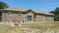 Snow School |
September 8, 1988 (#88001420) |
U.S. Route 271 34°23′48″N 95°24′45″W |
Snow | |
| 8 | Tuskahoma | 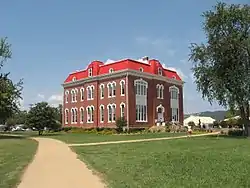 Tuskahoma |
July 28, 1970 (#70000537) |
163665 N. 4355 Rd. 34°38′30″N 95°16′43″W |
Tuskahoma |
See also
| Wikimedia Commons has media related to National Register of Historic Places in Pushmataha County, Oklahoma. |
References
- The latitude and longitude information provided in this table was derived originally from the National Register Information System, which has been found to be fairly accurate for about 99% of listings. Some locations in this table may have been corrected to current GPS standards.
- "National Register of Historic Places: Weekly List Actions". National Park Service, United States Department of the Interior. Retrieved on January 29, 2021.
- Numbers represent an alphabetical ordering by significant words. Various colorings, defined here, differentiate National Historic Landmarks and historic districts from other NRHP buildings, structures, sites or objects.
- "National Register Information System". National Register of Historic Places. National Park Service. March 13, 2009.
- The eight-digit number below each date is the number assigned to each location in the National Register Information System database, which can be viewed by clicking the number.
| Topics | |
|---|---|
| Lists by state |
|
| Lists by insular areas | |
| Lists by associated state | |
| Other areas | |
| Related | |
| |
Municipalities and communities of Pushmataha County, Oklahoma, United States | ||
|---|---|---|
| City | Pushmataha County map | |
| Towns | ||
| CDP | ||
| Other unincorporated communities | ||
| Ghost towns | ||
| Indian reservation | ||
| Footnotes | ‡This populated place also has portions in an adjacent county or counties | |
| ||
This article is issued from Wikipedia. The text is licensed under Creative Commons - Attribution - Sharealike. Additional terms may apply for the media files.