National Register of Historic Places listings in Rogers County, Oklahoma
This is a list of the National Register of Historic Places listings in Rogers County, Oklahoma.
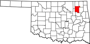
Location of Rogers County in Oklahoma
This is intended to be a complete list of the properties and districts on the National Register of Historic Places in Rogers County, Oklahoma, United States. The locations of National Register properties and districts for which the latitude and longitude coordinates are included below, may be seen in a map.[1]
There are 18 properties and districts listed on the National Register in the county.
- This National Park Service list is complete through NPS recent listings posted February 5, 2021.[2]
Current listings
| [3] | Name on the Register[4] | Image | Date listed[5] | Location | City or town | Description |
|---|---|---|---|---|---|---|
| 1 | I.W.W. Beck Building | 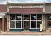 I.W.W. Beck Building |
September 10, 1999 (#99001086) |
146 W. Cooweescoowee Ave. 36°26′50″N 95°42′31″W |
Oologah | |
| 2 | The Belvidere | 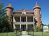 The Belvidere |
March 24, 1982 (#82003696) |
109 N. Chickasaw Ave. 36°18′39″N 95°36′37″W |
Claremore | |
| 3 | Chelsea Motel | 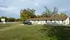 Chelsea Motel |
May 27, 2004 (#04000525) |
Junction of 1st and State Highway 66 36°32′15″N 95°25′33″W |
Chelsea | |
| 4 | Claremore Auto Dealership | February 23, 1995 (#95000042) |
625 W. Will Rogers Boulevard 36°18′46″N 95°37′02″W |
Claremore | ||
| 5 | Downtown Claremore Historic District |  Downtown Claremore Historic District |
September 12, 2016 (#16000623) |
W. Will Rogers Blvd. bounded by Rt. 66, Muskogee Ave., 4th St. & alley between W. Will Rogers Blvd. & 2nd St. 36°18′43″N 95°36′53″W |
Claremore | |
| 6 | Eastern University Preparatory School | 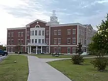 Eastern University Preparatory School |
February 19, 1982 (#82003697) |
College Hill 36°19′12″N 95°38′07″W |
Claremore | |
| 7 | Foyil Filling Station | 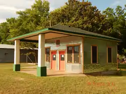 Foyil Filling Station |
December 8, 2015 (#15000875) |
12243 S. Andy Payne Blvd. 36°26′03″N 95°31′12″W |
Foyil | |
| 8 | Ed Galloway's Totem Pole Park | 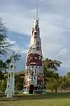 Ed Galloway's Totem Pole Park |
March 30, 1999 (#99000354) |
State Highway 28A, 3.5 miles east of the former U.S. Route 66 36°26′14″N 95°26′53″W |
Foyil | |
| 9 | Hanes Home | 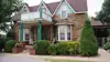 Hanes Home |
July 12, 1982 (#82003700) |
Off State Highway 88 36°20′04″N 95°39′06″W |
Sageeyah | |
| 10 | Hogue House | 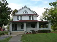 Hogue House |
December 17, 1982 (#82001498) |
1001 S. Olive St. 36°31′52″N 95°26′03″W |
Chelsea | |
| 11 | Mendenhall's Bath House | March 23, 1983 (#83002127) |
601 E. 7th St. 36°18′39″N 95°36′02″W |
Claremore | ||
| 12 | Maurice Meyer Barracks | Maurice Meyer Barracks |
March 1, 1982 (#82003698) |
College Hill 36°19′08″N 95°38′07″W |
Claremore | |
| 13 | Oologah Bank | 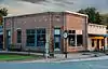 Oologah Bank |
May 10, 1982 (#82003699) |
105 S. Maple St. 36°26′48″N 95°42′35″W |
Oologah | |
| 14 | Oologah Pump |  Oologah Pump |
December 17, 1982 (#82001499) |
Maple and Cooweescoowee Sts. 36°26′48″N 95°42′35″W |
Oologah | |
| 15 | Pryor Creek Bridge | 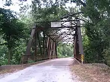 Pryor Creek Bridge |
September 6, 2006 (#06000796) |
Carries 1st St. over Pryor Creek, southwest of its junction with State Highway 66 36°32′18″N 95°24′54″W |
Chelsea | |
| 16 | Will Rogers Birthplace | 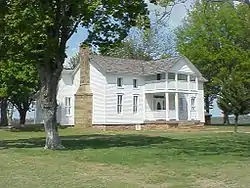 Will Rogers Birthplace |
September 29, 1970 (#70000538) |
About 4 miles northeast of Oologah 36°28′10″N 95°39′26″W |
Oologah | |
| 17 | Will Rogers Hotel | 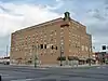 Will Rogers Hotel |
December 29, 1994 (#94001508) |
524 W. Will Rogers Boulevard 36°18′45″N 95°36′55″W |
Claremore | |
| 18 | Verdigris Club Lodge | 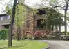 Verdigris Club Lodge |
September 2, 2003 (#03000876) |
27795 S. Skelly Dr. 36°12′43″N 95°37′44″W |
Catoosa |
See also
| Wikimedia Commons has media related to National Register of Historic Places in Rogers County, Oklahoma. |
References
- The latitude and longitude information provided in this table was derived originally from the National Register Information System, which has been found to be fairly accurate for about 99% of listings. Some locations in this table may have been corrected to current GPS standards.
- "National Register of Historic Places: Weekly List Actions". National Park Service, United States Department of the Interior. Retrieved on February 5, 2021.
- Numbers represent an alphabetical ordering by significant words. Various colorings, defined here, differentiate National Historic Landmarks and historic districts from other NRHP buildings, structures, sites or objects.
- "National Register Information System". National Register of Historic Places. National Park Service. March 13, 2009.
- The eight-digit number below each date is the number assigned to each location in the National Register Information System database, which can be viewed by clicking the number.
| Topics | |
|---|---|
| Lists by state |
|
| Lists by insular areas | |
| Lists by associated state | |
| Other areas | |
| Related | |
| |
Municipalities and communities of Rogers County, Oklahoma, United States | ||
|---|---|---|
| Cities | Rogers County map | |
| Towns | ||
| CDPs | ||
| Other unincorporated communities |
| |
| Indian reservations | ||
| Footnotes | ‡This populated place also has portions in an adjacent county or counties | |
| ||
This article is issued from Wikipedia. The text is licensed under Creative Commons - Attribution - Sharealike. Additional terms may apply for the media files.