National Register of Historic Places listings in Creek County, Oklahoma
This is a list of the National Register of Historic Places listings in Creek County, Oklahoma.
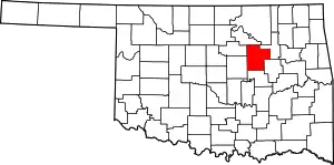
Location of Creek County in Oklahoma
This is intended to be a complete list of the properties and districts on the National Register of Historic Places in Creek County, Oklahoma, United States. The locations of National Register properties and districts for which the latitude and longitude coordinates are included below, may be seen in a map.[1]
There are 30 properties and districts listed on the National Register in the county.
- This National Park Service list is complete through NPS recent listings posted January 29, 2021.[2]
Current listings
| [3] | Name on the Register[4] | Image | Date listed[5] | Location | City or town | Description |
|---|---|---|---|---|---|---|
| 1 | Jackson Barnett No. 11 Oil Well | July 27, 1982 (#82003681) |
South of Drumright 35°58′26″N 96°35′04″W |
Drumright | ||
| 2 | Beard Motor Company |  Beard Motor Company |
May 27, 2004 (#04000522) |
210 E. 9th 35°50′08″N 96°23′16″W |
Bristow | |
| 3 | Berryhill Building | 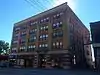 Berryhill Building |
November 30, 1999 (#99001423) |
14-20 E. Dewey Ave. 35°59′54″N 96°06′47″W |
Sapulpa | |
| 4 | Bridge No. 18 at Rock Creek | 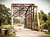 Bridge No. 18 at Rock Creek |
February 23, 1995 (#95000031) |
Junction of Old U.S. Route 66 and Rock Creek 35°59′37″N 96°08′11″W |
Sapulpa | 1921 Ozark Trail Warren truss bridge, part of U.S. Route 66 in Oklahoma until a 1952 realignment, closed to traffic as of 2013.[6] |
| 5 | Bristow Firestone Service Station | 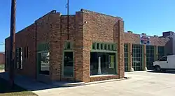 Bristow Firestone Service Station |
September 6, 2007 (#07000912) |
321 N. Main 35°50′07″N 96°23′25″W |
Bristow | |
| 6 | Bristow Motor Company Building | Bristow Motor Company Building |
February 23, 1995 (#95000032) |
500 N. Main St. 35°50′13″N 96°23′27″W |
Bristow | |
| 7 | Bristow Presbyterian Church | 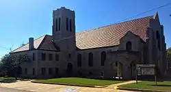 Bristow Presbyterian Church |
October 3, 1979 (#79001992) |
6th and Elm Sts. 35°49′57″N 96°23′35″W |
Bristow | |
| 8 | Bristow Tire Shop | 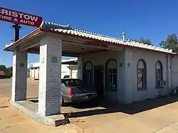 Bristow Tire Shop |
February 23, 1995 (#95000033) |
115 W. 4th St. 35°49′51″N 96°23′29″W |
Bristow | |
| 9 | Creek County Courthouse | 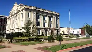 Creek County Courthouse |
March 22, 1985 (#85000679) |
222 E. Dewey Ave. 35°59′54″N 96°06′37″W |
Sapulpa | |
| 10 | Creek Masonic Lodge No. 226 | March 20, 2017 (#100000768) |
417 N. Main St. 35°50′11″N 96°23′28″W |
Bristow | ||
| 11 | Depew Route 66 Segment | 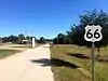 Depew Route 66 Segment |
September 10, 2014 (#14000593) |
US 66 E. from Milfay Rd. for .46 mi. 35°47′11″N 96°33′41″W |
Depew vicinity | |
| 12 | Drumright Gasoline Plant No. 2 | July 27, 1982 (#82003677) |
North of Drumright 36°00′33″N 96°34′57″W |
Drumright | ||
| 13 | Aaron Drumright House | August 17, 1982 (#82003678) |
403 S. Creek Ave. 35°59′08″N 96°36′24″W |
Drumright | ||
| 14 | First United Methodist Church of Drumright | March 31, 1982 (#82003679) |
115 N. Pennsylvania Ave. 35°59′21″N 96°36′07″W |
Drumright | ||
| 15 | John Frank House | 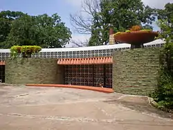 John Frank House |
March 20, 2002 (#02000221) |
1300 Luker Ln. 35°59′08″N 96°06′10″W |
Sapulpa | |
| 16 | J.W. Fulkerson House | March 23, 1982 (#82003680) |
508 E Broadway 35°59′18″N 96°35′43″W |
Drumright | ||
| 17 | House Building | September 9, 2020 (#100005554) |
301-305 North Main St. 35°50′06″N 96°23′28″W |
Bristow | ||
| 18 | Klingensmith Park Amphitheater | September 12, 2016 (#16000619) |
W. 7th, W. 5th & Country Club Dr. 35°49′57″N 96°24′08″W |
Bristow | ||
| 19 | Little Deep Fork Creek Bridge | December 5, 2003 (#03001237) |
0.33 miles east of the junction of E0830 Rd. and N3700 Rd. 35°48′49″N 96°26′06″W |
Bristow | ||
| 20 | Markham School and Teacherage | April 21, 1982 (#82003683) |
Southwest of Oilton 36°03′39″N 96°36′25″W |
Oilton | ||
| 21 | McClung House | June 27, 1980 (#80003262) |
708 S. Main St. 35°59′26″N 96°06′51″W |
Sapulpa | ||
| 22 | Meacham Building | April 21, 1982 (#82003682) |
102 E. Main St. 36°05′12″N 96°35′07″W |
Oilton | ||
| 23 | Santa Fe Depot | 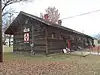 Santa Fe Depot |
April 2, 1981 (#81000460) |
Broadway and Harley Sts. 35°59′20″N 96°35′53″W |
Drumright | |
| 24 | Sapulpa Downtown Historic District | Sapulpa Downtown Historic District |
September 14, 2002 (#02000975) |
Roughly bounded by Hobson Ave., Elm St., Lee Ave., and Main St. 35°59′54″N 96°06′43″W |
Sapulpa | |
| 25 | Tank Farm Loop Route 66 Roadbed | 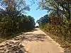 Tank Farm Loop Route 66 Roadbed |
September 6, 2006 (#06000797) |
Junction of State Highway 66 and Old U.S. Route 66, 0.6 miles west of the Interstate 44 overpass 35°54′33″N 96°18′50″W |
Bristow | |
| 26 | Texaco Service Station | 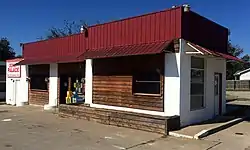 Texaco Service Station |
February 23, 1995 (#95000034) |
201 W. 4th Ave. 35°49′51″N 96°23′36″W |
Bristow | |
| 27 | Tidal School | April 2, 1981 (#81000461) |
South of Drumright off State Highway 16 35°57′46″N 96°35′04″W |
Drumright | ||
| 28 | Washington School | January 28, 1981 (#81000462) |
214 W. Federal St. 35°59′13″N 96°36′11″W |
Drumright | ||
| 29 | West Sapulpa Route 66 Roadbed |  West Sapulpa Route 66 Roadbed |
March 3, 2004 (#04000128) |
Junction of Ozark Trail of State Highway 66, 0.25 miles west of Sahoma Lake Rd. 35°59′31″N 96°09′45″W |
Sapulpa | |
| 30 | Wheeler No. 1 Oil Well | March 14, 1983 (#83002083) |
Off State Highway 99 35°59′58″N 96°35′50″W |
Drumright |
See also
| Wikimedia Commons has media related to National Register of Historic Places in Creek County, Oklahoma. |
References
- The latitude and longitude information provided in this table was derived originally from the National Register Information System, which has been found to be fairly accurate for about 99% of listings. Some locations in this table may have been corrected to current GPS standards.
- "National Register of Historic Places: Weekly List Actions". National Park Service, United States Department of the Interior. Retrieved on January 29, 2021.
- Numbers represent an alphabetical ordering by significant words. Various colorings, defined here, differentiate National Historic Landmarks and historic districts from other NRHP buildings, structures, sites or objects.
- "National Register Information System". National Register of Historic Places. National Park Service. March 13, 2009.
- The eight-digit number below each date is the number assigned to each location in the National Register Information System database, which can be viewed by clicking the number.
- "Bridge takes a traffic break". Sapulpa Herald Online. 2013-03-08. Archived from the original on 2013-04-11. Retrieved 2013-03-09.
| Bristow |
| |
|---|---|---|
| Depew |
| |
| Drumright |
| |
| Oilton |
| |
| Sapulpa |
| |
| Topics | |
|---|---|
| Lists by state |
|
| Lists by insular areas | |
| Lists by associated state | |
| Other areas | |
| Related | |
| |
Municipalities and communities of Creek County, Oklahoma, United States | ||
|---|---|---|
| Cities | Creek County map | |
| Towns | ||
| CDP | ||
| Unincorporated communities | ||
| Ghost town | ||
| Indian reservation | ||
| Footnotes | ‡This populated place also has portions in an adjacent county or counties | |
| ||
This article is issued from Wikipedia. The text is licensed under Creative Commons - Attribution - Sharealike. Additional terms may apply for the media files.