National Register of Historic Places listings in Pittsburg County, Oklahoma
This is a list of the National Register of Historic Places listings in Pittsburg County, Oklahoma.
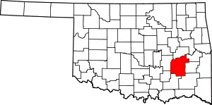
Location of Pittsburg County in Oklahoma
This is intended to be a complete list of the properties and districts on the National Register of Historic Places in Pittsburg County, Oklahoma, United States. The locations of National Register properties and districts for which the latitude and longitude coordinates are included below, may be seen in a map.[1]
There are 30 properties and districts listed on the National Register in the county. Another property was once listed but has been removed.
- This National Park Service list is complete through NPS recent listings posted January 29, 2021.[2]
Current listings
| [3] | Name on the Register[4] | Image | Date listed[5] | Location | City or town | Description |
|---|---|---|---|---|---|---|
| 1 | Aldridge Hotel | 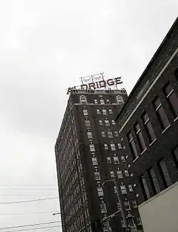 Aldridge Hotel |
December 7, 1995 (#95001408) |
200 E. Carl Albert Parkway 34°55′56″N 95°46′00″W |
McAlester | |
| 2 | Blackburn's Station Site |  Blackburn's Station Site |
March 7, 1973 (#73001568) |
9 miles southeast of Pittsburg 34°41′05″N 95°44′39″W |
Pittsburg | |
| 3 | Busby Office Building | 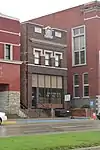 Busby Office Building |
December 6, 1979 (#79002021) |
113 E. Carl Albert Parkway 34°55′59″N 95°46′03″W |
McAlester | |
| 4 | Busby Theatre | 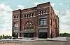 Busby Theatre |
December 6, 1979 (#79002022) |
Washington Ave. and 2nd St. 34°56′01″N 95°46′00″W |
McAlester | Demolished in 1983[6] |
| 5 | Canadian Jail and Livery Stable | November 6, 1980 (#80003295) |
Off State Highway 113 35°10′43″N 95°39′22″W |
Canadian | ||
| 6 | Choate Cabin | 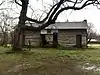 Choate Cabin |
October 3, 1979 (#79002019) |
2nd and Walnut Sts. 35°09′36″N 95°46′24″W |
Indianola | |
| 7 | Cole Chapel School | 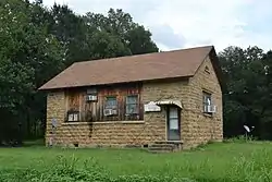 Cole Chapel School |
September 8, 1988 (#88001411) |
North of Hartshorne 34°54′19″N 95°32′32″W |
Hartshorne | |
| 8 | Federal Building and US Courthouse | 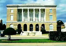 Federal Building and US Courthouse |
March 24, 2000 (#00000242) |
301 E. Carl Albert Pkwy.[7] 34°55′56″N 95°45′54″W |
McAlester | |
| 9 | First Presbyterian Church | 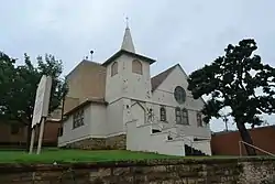 First Presbyterian Church |
December 11, 1979 (#79003139) |
101 E. Washington Ave. 34°56′03″N 95°46′03″W |
McAlester | |
| 10 | Hokey's Drugstore | December 6, 1979 (#79002020) |
2 E. Washington Ave. 34°55′39″N 95°42′56″W |
Krebs | ||
| 11 | International Temple, Supreme Assembly, Order of the Rainbow for Girls | 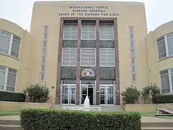 International Temple, Supreme Assembly, Order of the Rainbow for Girls |
June 14, 2013 (#13000393) |
315 E. Carl Albert Pkwy. 34°55′57″N 95°45′53″W |
McAlester | |
| 12 | L'Ouverture Gymnasium | 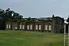 L'Ouverture Gymnasium |
May 26, 2006 (#06000486) |
Junction of S. 14th St. and E Chickasaw Ave. 34°55′32″N 95°45′02″W |
McAlester | |
| 13 | Jeff Lee Park Bath House and Pool | 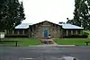 Jeff Lee Park Bath House and Pool |
September 8, 1988 (#88001413) |
3rd and Fillmore Sts. 34°56′41″N 95°45′37″W |
McAlester | |
| 14 | Mass Grave of the Mexican Miners | November 14, 1980 (#80003297) |
Mount Calvary Cemetery 34°55′39″N 95°44′32″W |
McAlester | ||
| 15 | McAlester Armory | 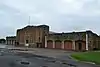 McAlester Armory |
September 8, 1988 (#88001412) |
3rd and Polk Sts. 34°56′36″N 95°45′38″W |
McAlester | |
| 16 | McAlester Downtown Historic District | 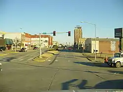 McAlester Downtown Historic District |
March 10, 2015 (#15000065) |
Bounded by Business 69, E. Carl Albert Pkwy., N. 5th St. & RR tracks 34°55′53″N 95°45′58″W |
McAlester | |
| 17 | McAlester DX | August 29, 1980 (#80004288) |
5th St. and Carl Albert Parkway 34°55′56″N 95°45′50″W |
McAlester | ||
| 18 | McAlester House | 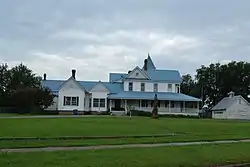 McAlester House |
August 29, 1980 (#80004289) |
14 E. Smith Ave. 34°57′20″N 95°45′38″W |
McAlester | |
| 19 | McAlester Scottish Rite Temple | 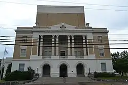 McAlester Scottish Rite Temple |
November 22, 1980 (#80004521) |
2nd St. and Adams Ave. 34°56′07″N 95°45′56″W |
McAlester | |
| 20 | Mine Rescue Station Building | 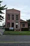 Mine Rescue Station Building |
March 13, 1980 (#80004290) |
509 S. 3rd St. 34°55′34″N 95°46′05″W |
McAlester | |
| 21 | New State School | September 8, 1988 (#88001414) |
South of Hartshorne near North Fork Elm Creek 34°43′50″N 95°36′05″W |
Hartshorne | ||
| 22 | OKLA Theater | 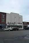 OKLA Theater |
June 5, 2003 (#03000513) |
18 E. Choctaw 34°55′55″N 95°46′09″W |
McAlester | |
| 23 | Perryville | May 5, 1972 (#72001076) |
Southwest of McAlester on U.S. Route 69 34°52′08″N 95°48′54″W |
McAlester | ||
| 24 | Pittsburg County Courthouse | 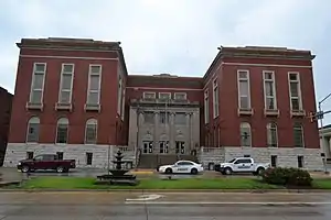 Pittsburg County Courthouse |
August 23, 1984 (#84003415) |
115 E. Carl Albert Pkwy. 34°55′59″N 95°46′02″W |
McAlester | |
| 25 | Pittsburg School and Gymnasium | 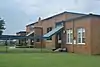 Pittsburg School and Gymnasium |
September 8, 1988 (#88001415) |
Off State Highway 63 34°42′55″N 95°51′14″W |
Pittsburg | |
| 26 | Rock Creek Bridge | September 4, 2008 (#08000853) |
Carries County Road NS-409.7 over Rock Creek 34°38′56″N 95°43′56″W |
Blanco | ||
| 27 | St. Joseph's Catholic Church | 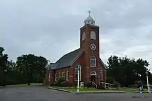 St. Joseph's Catholic Church |
November 12, 1980 (#80003296) |
Off State Highway 31 34°55′56″N 95°43′05″W |
Krebs | |
| 28 | Saints Cyril and Methodius Russian Orthodox Greek Catholic Church | September 8, 2017 (#100001594) |
501 S. 3rd St. 34°50′36″N 95°34′13″W |
Hartshorne | ||
| 29 | Tipton Ridge School | September 8, 1988 (#88001417) |
North of Blocker 35°07′15″N 95°30′26″W |
Blocker | ||
| 30 | Warden's House | June 17, 2005 (#05000615) |
Penitentiary Boulevard and West St. 34°57′09″N 95°46′55″W |
McAlester |
Former listings
| [3] | Name on the Register | Image | Date listed | Date removed | Location | City or town | Summary |
|---|---|---|---|---|---|---|---|
| 1 | Southern Ice and Cold Storage Company | October 11, 1979 (#79002023) | June 2, 2014 | 338 E. Choctaw Ave. 34°55′51″N 95°45′49″W |
Pittsburg |
See also
| Wikimedia Commons has media related to National Register of Historic Places in Pittsburg County, Oklahoma. |
References
- The latitude and longitude information provided in this table was derived originally from the National Register Information System, which has been found to be fairly accurate for about 99% of listings. Some locations in this table may have been corrected to current GPS standards.
- "National Register of Historic Places: Weekly List Actions". National Park Service, United States Department of the Interior. Retrieved on January 29, 2021.
- Numbers represent an alphabetical ordering by significant words. Various colorings, defined here, differentiate National Historic Landmarks and historic districts from other NRHP buildings, structures, sites or objects.
- "National Register Information System". National Register of Historic Places. National Park Service. March 13, 2009.
- The eight-digit number below each date is the number assigned to each location in the National Register Information System database, which can be viewed by clicking the number.
- "McAlester Historical Landmark Theater to Fall". The Oklahoman. February 6, 1983. Retrieved September 11, 2017.
- Carl Albert Federal Building and Courthouse. Accessed April 5, 2016.
| Topics | |
|---|---|
| Lists by state |
|
| Lists by insular areas | |
| Lists by associated state | |
| Other areas | |
| Related | |
| |
| Blanco |
| |
|---|---|---|
| Blocker |
| |
| Canadian |
| |
| Hartshorne |
| |
| Indianola |
| |
| Krebs |
| |
| McAlester |
| |
| Pittsburg |
| |
Municipalities and communities of Pittsburg County, Oklahoma, United States | ||
|---|---|---|
| Cities | Pittsburg County map | |
| Towns | ||
| CDPs | ||
| Other unincorporated communities | ||
| Ghost town | ||
| Indian reservation | ||
| Footnotes | ‡This populated place also has portions in another county or counties | |
| ||
This article is issued from Wikipedia. The text is licensed under Creative Commons - Attribution - Sharealike. Additional terms may apply for the media files.