National Register of Historic Places listings in Garvin County, Oklahoma
This is a list of the National Register of Historic Places listings in Garvin County, Oklahoma.
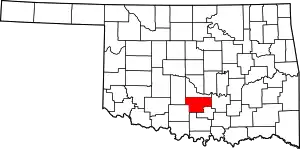
Location of Garvin County in Oklahoma
This is intended to be a complete list of the properties and districts on the National Register of Historic Places in Garvin County, Oklahoma, United States. The locations of National Register properties and districts for which the latitude and longitude coordinates are included below, may be seen in a map.[1]
There are 12 properties and districts listed on the National Register in the county.
- This National Park Service list is complete through NPS recent listings posted January 29, 2021.[2]
Current listings
| [3] | Name on the Register[4] | Image | Date listed[5] | Location | City or town | Description |
|---|---|---|---|---|---|---|
| 1 | Antioch Dependent School District No. 15 | 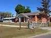 Antioch Dependent School District No. 15 |
December 6, 2004 (#04001333) |
0.5 miles west of the junction of Antioch Rd and State Highway 74 34°43′30″N 97°24′42″W |
Elmore City | |
| 2 | Beaty School | September 8, 2017 (#100001592) |
Cty. Rd. 3210 at Royal Oaks Rd. 34°43′29″N 97°16′59″W |
Pauls Valley vicinity | ||
| 3 | Erin Springs Mansion | 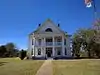 Erin Springs Mansion |
June 22, 1970 (#70000534) |
South of the Washita River 34°48′30″N 97°36′16″W |
Erin Springs | |
| 4 | Eskridge Hotel | 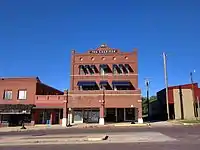 Eskridge Hotel |
October 3, 1979 (#79001994) |
114 E. Robert S. Kerr St. 34°38′36″N 97°10′10″W |
Wynnewood | |
| 5 | First National Bank Building | 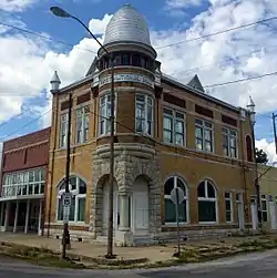 First National Bank Building |
June 14, 2001 (#01000659) |
100 W. Main 34°47′44″N 96°57′44″W |
Stratford | |
| 6 | Fort Arbuckle Site | June 13, 1972 (#72001064) |
About 0.5 miles north of Hoover on State Highway 7 34°31′39″N 97°15′00″W |
Hoover | ||
| 7 | Garvin County Courthouse | 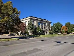 Garvin County Courthouse |
November 8, 1985 (#85002758) |
Courthouse Sq. and Grant Ave. 34°44′25″N 97°13′18″W |
Pauls Valley | |
| 8 | Hargis-Mitchell-Cochran House | 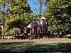 Hargis-Mitchell-Cochran House |
June 2, 1982 (#82003684) |
204 E. Robert S. Kerr St. 34°38′35″N 97°10′08″W |
Wynnewood | |
| 9 | Initial Point | October 6, 1970 (#70000533) |
About 7.5 miles west of Davis on the Garvin/Murray county line 34°30′24″N 97°14′49″W |
Davis | Extends into Murray County | |
| 10 | Moore-Settle House | 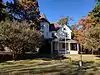 Moore-Settle House |
March 25, 1983 (#83002086) |
508 E. Cherokee St. 34°38′34″N 97°09′50″W |
Wynnewood | |
| 11 | Pauls Valley Historic District | 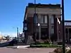 Pauls Valley Historic District |
February 1, 1979 (#79001993) |
Roughly bounded by railroad tracks, Grant Ave., and Joy St. 34°44′24″N 97°13′10″W |
Pauls Valley | |
| 12 | Santa Fe Depot of Lindsay | 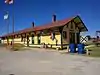 Santa Fe Depot of Lindsay |
April 25, 1986 (#86000863) |
120 N. Main 34°50′14″N 97°36′09″W |
Lindsay |
See also
| Wikimedia Commons has media related to National Register of Historic Places in Garvin County, Oklahoma. |
References
- The latitude and longitude information provided in this table was derived originally from the National Register Information System, which has been found to be fairly accurate for about 99% of listings. Some locations in this table may have been corrected to current GPS standards.
- "National Register of Historic Places: Weekly List Actions". National Park Service, United States Department of the Interior. Retrieved on January 29, 2021.
- Numbers represent an alphabetical ordering by significant words. Various colorings, defined here, differentiate National Historic Landmarks and historic districts from other NRHP buildings, structures, sites or objects.
- "National Register Information System". National Register of Historic Places. National Park Service. March 13, 2009.
- The eight-digit number below each date is the number assigned to each location in the National Register Information System database, which can be viewed by clicking the number.
| Topics | |
|---|---|
| Lists by state |
|
| Lists by insular areas | |
| Lists by associated state | |
| Other areas | |
| Related | |
| |
Municipalities and communities of Garvin County, Oklahoma, United States | ||
|---|---|---|
| Cities | Garvin County map | |
| Towns | ||
| Unincorporated communities | ||
| Ghost town | ||
| Indian reservation | ||
| Footnotes | ‡This populated place also has portions in an adjacent county or counties | |
| ||
This article is issued from Wikipedia. The text is licensed under Creative Commons - Attribution - Sharealike. Additional terms may apply for the media files.