National Register of Historic Places listings in Wagoner County, Oklahoma
This is a list of the National Register of Historic Places listings in Wagoner County, Oklahoma.
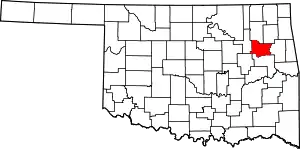
Location of Wagoner County in Oklahoma
This is intended to be a complete list of the properties and districts on the National Register of Historic Places in Wagoner County, Oklahoma, United States. The locations of National Register properties and districts for which the latitude and longitude coordinates are included below, may be seen in a map.[1]
There are 20 properties and districts listed on the National Register in the county.
- This National Park Service list is complete through NPS recent listings posted January 29, 2021.[2]
Current listings
| [3] | Name on the Register[4] | Image | Date listed[5] | Location | City or town | Description |
|---|---|---|---|---|---|---|
| 1 | Cobb Building |  Cobb Building |
September 13, 1982 (#82003709) |
203 E. Cherokee St. 35°57′37″N 95°22′34″W |
Wagoner | |
| 2 | First National Bank of Wagoner | 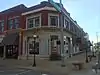 First National Bank of Wagoner |
March 10, 1983 (#83002140) |
114 E. Cherokee St. 35°57′34″N 95°22′38″W |
Wagoner | |
| 3 | First Presbyterian Church of Coweta | 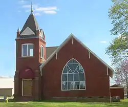 First Presbyterian Church of Coweta |
March 7, 2003 (#03000099) |
200 S. Ave. B 35°56′58″N 95°39′06″W |
Coweta | |
| 4 | John W. Gibson House | 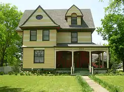 John W. Gibson House |
July 6, 1982 (#82003710) |
402 S. McQuarrie 35°57′22″N 95°22′01″W |
Wagoner | |
| 5 | Jamison Cemetery | June 20, 2012 (#12000349) |
2 miles (3.2 km) south on OK 16 & 2 miles (3.2 km) west on County Rd. E0820 35°50′16″N 95°21′26″W |
Okay vicinity | ||
| 6 | Koweta Mission Site |  Koweta Mission Site |
June 19, 1973 (#73001571) |
1 mile (1.6 km) south of Coweta off State Highway 51B 35°55′52″N 95°38′37″W |
Coweta | |
| 7 | A. J. Mason Building | August 5, 1985 (#85001743) |
Lincoln St. 35°50′20″N 95°26′18″W |
Tullahassee | ||
| 8 | William McAnally House | July 6, 1982 (#82003711) |
702 7th St., SE. 35°57′04″N 95°22′02″W |
Wagoner | ||
| 9 | Collin McKinney House | 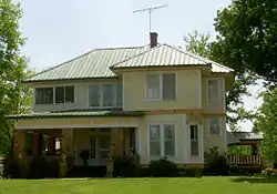 Collin McKinney House |
July 6, 1982 (#82003708) |
1106 7th St., SE 35°57′05″N 95°21′44″W |
Wagoner | |
| 10 | Miller-Washington School | September 28, 1984 (#84003448) |
Market St. 35°53′49″N 95°35′13″W |
Redbird | ||
| 11 | Newport Hotel and Restaurant | 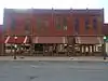 Newport Hotel and Restaurant |
December 4, 1985 (#85003079) |
202 S. Main 35°57′31″N 95°22′38″W |
Wagoner | |
| 12 | Amos Parkinson House | 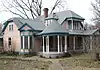 Amos Parkinson House |
July 6, 1982 (#82003712) |
601 N. Parkinson 35°57′55″N 95°22′26″W |
Wagoner | |
| 13 | Frederick Parkinson House | 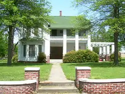 Frederick Parkinson House |
July 6, 1982 (#82003713) |
407 3rd St., NE. 35°57′48″N 95°22′23″W |
Wagoner | |
| 14 | Red Bird City Hall | September 28, 1984 (#84003450) |
Boston St. 35°53′40″N 95°35′22″W |
Redbird | ||
| 15 | Rio Grande Ranch Headquarters Historic District | September 9, 1992 (#92001191) |
State Highway 251A, 3 miles (4.8 km) east of Okay 35°50′53″N 95°15′29″W |
Okay | ||
| 16 | St James Episcopal Church | 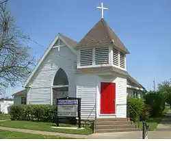 St James Episcopal Church |
May 11, 1982 (#82003714) |
303 S. Church St. 35°57′30″N 95°22′22″W |
Wagoner | |
| 17 | Tullahassee Mission Site | September 10, 1971 (#71000674) |
Address Restricted |
Tullahassee | ||
| 18 | Van Tuyl Homeplace | February 7, 1978 (#78002276) |
North of Porter 35°55′48″N 95°32′32″W |
Porter | ||
| 19 | Wagoner Armory | 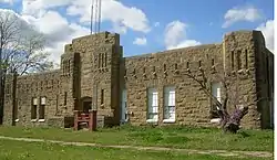 Wagoner Armory |
May 20, 1994 (#94000490) |
509 E. Cherokee St. 35°57′36″N 95°22′15″W |
Wagoner | |
| 20 | Way House | July 6, 1982 (#82003715) |
411 2nd St., NE. 35°57′43″N 95°22′20″W |
Wagoner | Apparently demolished for church expansion, c2010 |
See also
| Wikimedia Commons has media related to National Register of Historic Places in Wagoner County, Oklahoma. |
References
- The latitude and longitude information provided in this table was derived originally from the National Register Information System, which has been found to be fairly accurate for about 99% of listings. Some locations in this table may have been corrected to current GPS standards.
- "National Register of Historic Places: Weekly List Actions". National Park Service, United States Department of the Interior. Retrieved on January 29, 2021.
- Numbers represent an alphabetical ordering by significant words. Various colorings, defined here, differentiate National Historic Landmarks and historic districts from other NRHP buildings, structures, sites or objects.
- "National Register Information System". National Register of Historic Places. National Park Service. March 13, 2009.
- The eight-digit number below each date is the number assigned to each location in the National Register Information System database, which can be viewed by clicking the number.
| Topics | |
|---|---|
| Lists by state |
|
| Lists by insular areas | |
| Lists by associated state | |
| Other areas | |
| Related | |
| |
| Coweta | ||
|---|---|---|
| Okay |
| |
| Porter |
| |
| Redbird |
| |
| Tullahassee | ||
| Wagoner |
| |
This article is issued from Wikipedia. The text is licensed under Creative Commons - Attribution - Sharealike. Additional terms may apply for the media files.