National Register of Historic Places listings in Ottawa County, Oklahoma
This is a list of the National Register of Historic Places listings in Ottawa County, Oklahoma.
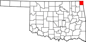
Location of Ottawa County in Oklahoma
This is intended to be a complete list of the properties and districts on the National Register of Historic Places in Ottawa County, Oklahoma, United States. The locations of National Register properties and districts for which the latitude and longitude coordinates are included below, may be seen in a map.[1]
There are 18 properties and districts listed on the National Register in the county.
- This National Park Service list is complete through NPS recent listings posted January 29, 2021.[2]
Current listings
| [3] | Name on the Register[4] | Image | Date listed[5] | Location | City or town | Description |
|---|---|---|---|---|---|---|
| 1 | Cities Service Station | February 23, 1995 (#95000039) |
Junction of 1st St. and Central Ave. 36°41′33″N 94°57′56″W |
Afton | ||
| 2 | Coleman Theatre |  Coleman Theatre |
May 19, 1983 (#83002114) |
103 N. Main St. 36°52′34″N 94°52′39″W |
Miami | |
| 3 | George L. Coleman Sr. House | 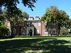 George L. Coleman Sr. House |
May 9, 1983 (#83002113) |
1001 Rockdale St. 36°53′00″N 94°51′40″W |
Miami | |
| 4 | Commerce Building/Hancock Building | 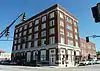 Commerce Building/Hancock Building |
May 9, 1983 (#83002115) |
103 E. Central 36°52′28″N 94°52′35″W |
Miami | |
| 5 | Dobson Family House |  Dobson Family House |
June 8, 2011 (#11000340) |
106 A St., SW 36°52′24″N 94°52′43″W |
Miami | |
| 6 | Horse Creek Bridge |  Horse Creek Bridge |
February 23, 1995 (#95000040) |
Junction of the former U.S. Route 66 and Horse Creek 36°41′49″N 94°57′23″W |
Afton | |
| 7 | John Patrick McNaughton Barn | 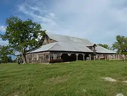 John Patrick McNaughton Barn |
December 27, 1991 (#91001903) |
Ottawa County Road 137, 1.5 miles north of State Highway 10 36°53′53″N 94°47′07″W |
Quapaw | |
| 8 | Miami Downtown Historic District | Miami Downtown Historic District |
May 29, 2009 (#09000357) |
Roughly the 100 block of N. Main St., the 0 block of S. Main St., the 0 blocks of E. and W. Central Ave., and the 0 block of SE. A St. 36°52′29″N 94°52′39″W |
Miami | |
| 9 | Miami Marathon Oil Company Service Station | 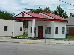 Miami Marathon Oil Company Service Station |
February 23, 1995 (#95000041) |
331 S. Main St. 36°52′11″N 94°52′37″W |
Miami | |
| 10 | Miami Original Nine-Foot Section of Route 66 Roadbed |  Miami Original Nine-Foot Section of Route 66 Roadbed |
February 9, 1995 (#94001610) |
From the junction of E St., SW. and 130th St. to the former U.S. Route 66 36°49′22″N 94°54′31″W |
Miami | |
| 11 | Modoc Mission Church and Cemetery | 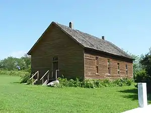 Modoc Mission Church and Cemetery |
February 15, 1980 (#80003293) |
Southeast of Miami 36°51′53″N 94°39′43″W |
Miami | |
| 12 | Narcissa D-X Gas Station | December 5, 2003 (#03001240) |
15050 S. Highway 69 36°48′03″N 94°55′36″W |
Miami | ||
| 13 | Ottawa County Courthouse | March 3, 2004 (#04000122) |
102 East Central 36°52′27″N 94°52′33″W |
Miami | Note: Demolished in 2008 | |
| 14 | Peoria Indian School |  Peoria Indian School |
March 21, 1983 (#83002116) |
East of Miami 36°54′52″N 94°44′31″W |
Miami | |
| 15 | Peoria Tribal Cemetery |  Peoria Tribal Cemetery |
March 21, 1983 (#83002117) |
East of Miami 36°54′01″N 94°45′39″W |
Miami | |
| 16 | Riviera Courts-Motel |  Riviera Courts-Motel |
May 27, 2004 (#04000524) |
1 mile west of Main on U.S. Route 69A 36°51′56″N 94°54′01″W |
Miami | |
| 17 | Tri-State Zinc and Lead Ore Producers Association Office | 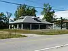 Tri-State Zinc and Lead Ore Producers Association Office |
March 7, 2003 (#03000097) |
508 N. Connell Ave. 36°59′28″N 94°49′52″W |
Picher | Destroyed by arson in April 2015 |
| 18 | Isaiah Walker House | March 20, 2017 (#100000769) |
69491 E. 134th Rd. 36°49′19″N 94°38′02″W |
Wyandotte |
See also
| Wikimedia Commons has media related to National Register of Historic Places in Ottawa County, Oklahoma. |
References
- The latitude and longitude information provided in this table was derived originally from the National Register Information System, which has been found to be fairly accurate for about 99% of listings. Some locations in this table may have been corrected to current GPS standards.
- "National Register of Historic Places: Weekly List Actions". National Park Service, United States Department of the Interior. Retrieved on January 29, 2021.
- Numbers represent an alphabetical ordering by significant words. Various colorings, defined here, differentiate National Historic Landmarks and historic districts from other NRHP buildings, structures, sites or objects.
- "National Register Information System". National Register of Historic Places. National Park Service. March 13, 2009.
- The eight-digit number below each date is the number assigned to each location in the National Register Information System database, which can be viewed by clicking the number.
| Afton |
| |
|---|---|---|
| Miami |
| |
| Picher |
| |
| Picher | ||
| Wyandotte |
| |
| Topics | |
|---|---|
| Lists by state |
|
| Lists by insular areas | |
| Lists by associated state | |
| Other areas | |
| Related | |
| |
Municipalities and communities of Ottawa County, Oklahoma, United States | ||
|---|---|---|
| Cities | Ottawa County map | |
| Towns | ||
| CDPs | ||
| Unincorporated communities |
| |
| Ghost towns | ||
| Indian reservation | ||
| Footnotes | ‡This populated place also has portions in an adjacent county or counties | |
| ||
This article is issued from Wikipedia. The text is licensed under Creative Commons - Attribution - Sharealike. Additional terms may apply for the media files.