National Register of Historic Places listings in Chicot County, Arkansas
This is a list of the National Register of Historic Places listings in Chicot County, Arkansas.
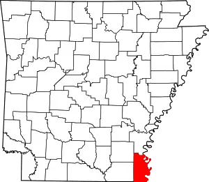
Location of Chicot County in Arkansas
This is intended to be a complete list of the properties on the National Register of Historic Places in Chicot County, Arkansas, United States. The locations of National Register properties for which the latitude and longitude coordinates are included below, may be seen in a map.[1]
There are 22 properties listed on the National Register in the county.
- This National Park Service list is complete through NPS recent listings posted January 29, 2021.[2]
Current listings
| [3] | Name on the Register[4] | Image | Date listed[5] | Location | City or town | Description |
|---|---|---|---|---|---|---|
| 1 | American Legion Post No. 127 Building | 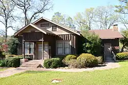 American Legion Post No. 127 Building |
October 8, 1992 (#92001350) |
Northeastern corner of the junction of Cherry and Armstrong Sts. 33°06′37″N 91°15′50″W |
Eudora | |
| 2 | Dr. A.G. Anderson House | 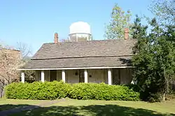 Dr. A.G. Anderson House |
July 24, 1992 (#92000929) |
Junction of Duncan and Main Sts. 33°06′33″N 91°15′41″W |
Eudora | |
| 3 | Carlton House | 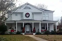 Carlton House |
June 5, 1991 (#91000692) |
434 S. Lakeshore Dr. 33°19′33″N 91°16′59″W |
Lake Village | ca. 1906 Colonial Revival house |
| 4 | Chicot County Courthouse | 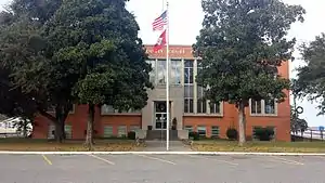 Chicot County Courthouse |
February 1, 2006 (#05001592) |
108 Main St. 33°29′00″N 91°16′55″W |
Lake Village | 1956 Art Deco-inspired county courthouse |
| 5 | Chicot County Training School | 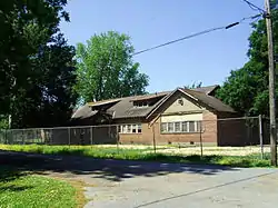 Chicot County Training School |
May 26, 2004 (#04000490) |
Junction of Hazel and N. School St. 33°32′08″N 91°26′19″W |
Dermott | |
| 6 | Crenshaw-Burleigh House | 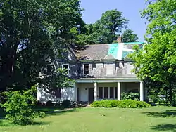 Crenshaw-Burleigh House |
January 27, 2012 (#11001047) |
108 N. Main St. 33°31′37″N 91°26′12″W |
Dermott | |
| 7 | M.E. Davis House | 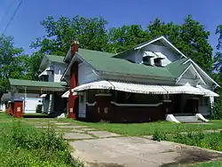 M.E. Davis House |
September 22, 2004 (#04001034) |
200 N. Knox St. 33°31′47″N 91°26′27″W |
Dermott | |
| 8 | Dermott Bank & Trust Company Building | 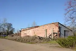 Dermott Bank & Trust Company Building |
May 19, 1994 (#94000466) |
Northwestern corner of the junction of N. Arkansas and E. Iowa Sts. 33°31′41″N 91°26′01″W |
Dermott | |
| 9 | Dermott Commercial Historic District | 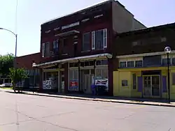 Dermott Commercial Historic District |
September 23, 2010 (#10000789) |
101-120 N. Freeman St.; 101-219 E. Iowa St. and 131 N. Main St. 33°31′40″N 91°26′05″W |
Dermott | |
| 10 | Sam Epstein House | September 21, 1992 (#92001226) |
488 Lakeshore Dr. 33°19′34″N 91°16′59″W |
Lake Village | House burned on June 30, 2012. | |
| 11 | Eudora City Hall | 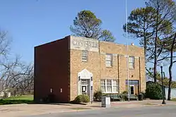 Eudora City Hall |
October 5, 2006 (#06000910) |
239 S. Main St. 33°06′37″N 91°15′42″W |
Eudora | |
| 12 | First Baptist Church | 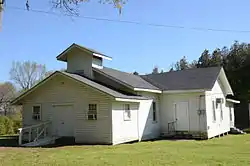 First Baptist Church |
June 3, 1998 (#98000645) |
Highway 159, S., 1 mile south of Eudora 33°05′24″N 91°16′08″W |
Eudora | |
| 13 | Gregory Dipping Vat | September 20, 2006 (#06000830) |
122 Rogers Rd. 33°18′50″N 91°19′55″W |
Lake Village | ||
| 14 | Harden Family Cemetery | May 24, 2004 (#04000508) |
Hardin Rd. 33°16′24″N 91°16′38″W |
Jennie | ||
| 15 | Lake Village Commercial Historic District | 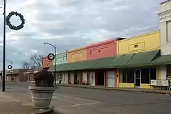 Lake Village Commercial Historic District |
February 18, 2011 (#11000025) |
Roughly bounded by Lakeshore Dr., Jackson St., Chicot St., and Church St. 33°19′52″N 91°16′58″W |
Lake Village | 1906-1960 commercial center of the Chicot County seat of government |
| 16 | Lake Village Confederate Monument | 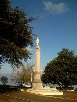 Lake Village Confederate Monument |
May 3, 1996 (#96000509) |
Lakeshore Dr. median, between Main and Jackson Sts. 33°19′51″N 91°17′05″W |
Lake Village | 1910 commemorative sculpture |
| 17 | Lake Village Post Office | 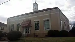 Lake Village Post Office |
August 14, 1998 (#98000916) |
206 S. Cokley St. 33°19′49″N 91°17′00″W |
Lake Village | 1938 structure featuring interior Depression-era mural |
| 18 | Lakeport Plantation | 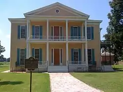 Lakeport Plantation |
November 20, 1974 (#74000466) |
About 3 miles southeast of Shives, off Highway 142 33°15′24″N 91°09′19″W |
Shives | ca. 1859 plantation house, best extant example of antebellum plantations in Arkansas |
| 19 | A. Landi General Merchandise Building | October 8, 1992 (#92001347) |
Highway 8 33°05′31″N 91°12′38″W |
Grand Lake | Demolished | |
| 20 | Dr. E.P. McGehee Infirmary | 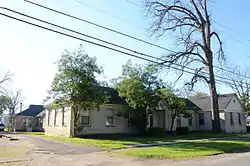 Dr. E.P. McGehee Infirmary |
June 1, 2005 (#05000487) |
614 S. Cokley St. 33°19′43″N 91°17′05″W |
Lake Village | |
| 21 | New Hope Missionary Baptist Church Cemetery, Historic Section | 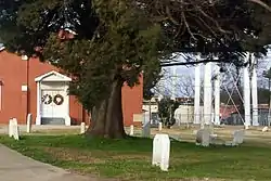 New Hope Missionary Baptist Church Cemetery, Historic Section |
September 21, 1992 (#92001227) |
St. Marys St. 33°19′48″N 91°17′12″W |
Lake Village | early 20th-century graves associated with town's black community |
| 22 | John Tushek Building | 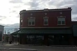 John Tushek Building |
August 5, 1993 (#93000811) |
108 Main St. 33°19′53″N 91°16′57″W |
Lake Village | 1906 Beaux Arts-style commercial building |
Former listings
| [3] | Name on the Register | Image | Date listed | Date removed | Location | City or town | Summary |
|---|---|---|---|---|---|---|---|
| 1 | Bunker House | 1992 (#92001622) | October 4, 1999 | AR 159 W of jct. with US 65/82 |
Lake Village | ||
| 2 | P. and J. Liberto-Rosa Portera Building | October 8, 1992 (#92001348) | January 14, 2002 | Main Street |
Eudora | ||
| 3 | Walker House | 1982 (#82000799) | September 24, 2004 | 606 Main St. |
Dermott |
See also
| Wikimedia Commons has media related to National Register of Historic Places in Chicot County, Arkansas. |
References
- The latitude and longitude information provided in this table was derived originally from the National Register Information System, which has been found to be fairly accurate for about 99% of listings. Some locations in this table may have been corrected to current GPS standards.
- "National Register of Historic Places: Weekly List Actions". National Park Service, United States Department of the Interior. Retrieved on January 29, 2021.
- Numbers represent an alphabetical ordering by significant words. Various colorings, defined here, differentiate National Historic Landmarks and historic districts from other NRHP buildings, structures, sites or objects.
- "National Register Information System". National Register of Historic Places. National Park Service. March 13, 2009.
- The eight-digit number below each date is the number assigned to each location in the National Register Information System database, which can be viewed by clicking the number.
| Topics | |
|---|---|
| Lists by state |
|
| Lists by insular areas | |
| Lists by associated state | |
| Other areas | |
| Related | |
| |
Municipalities and communities of Chicot County, Arkansas, United States | ||
|---|---|---|
| Cities | Map of Arkansas highlighting Chicot County | |
| Unincorporated communities | ||
| Ghost town | ||
| ||
This article is issued from Wikipedia. The text is licensed under Creative Commons - Attribution - Sharealike. Additional terms may apply for the media files.