National Register of Historic Places listings in Cleburne County, Arkansas
This is a list of the National Register of Historic Places listings in Cleburne County, Arkansas.
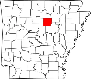
Location of Cleburne County in Arkansas
This is intended to be a complete list of the properties and districts on the National Register of Historic Places in Cleburne County, Arkansas, United States. The locations of National Register properties and districts for which the latitude and longitude coordinates are included below, may be seen in a map.[1]
There are 17 properties and districts listed on the National Register in the county.
- This National Park Service list is complete through NPS recent listings posted February 5, 2021.[2]
Current listings
| [3] | Name on the Register[4] | Image | Date listed[5] | Location | City or town | Description |
|---|---|---|---|---|---|---|
| 1 | Brewer School |  Brewer School |
May 26, 2004 (#04000506) |
Brewer Rd. 35°40′09″N 92°10′57″W |
Brewer | |
| 2 | Cleburne County Courthouse | 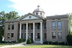 Cleburne County Courthouse |
July 12, 1976 (#76000393) |
Courthouse Sq. 35°29′27″N 92°01′55″W |
Heber Springs | |
| 3 | Cleburne County Farm Cemetery |  Cleburne County Farm Cemetery |
September 28, 2005 (#05001066) |
Southeastern corner of the junction of Plantation Dr., E., and Deer Run 35°27′20″N 92°02′15″W |
Heber Springs | |
| 4 | Dr. Cyrus F. Crosby House | 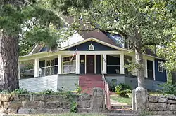 Dr. Cyrus F. Crosby House |
November 19, 1993 (#93001258) |
202 N. Broadway St. 35°29′33″N 92°01′40″W |
Heber Springs | |
| 5 | Dill School | 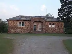 Dill School |
August 16, 1994 (#94000854) |
Western side of Highways 5 and 25, north of Ida 35°35′39″N 91°55′59″W |
Ida | |
| 6 | Mike Meyer Disfarmer Gravesite |  Mike Meyer Disfarmer Gravesite |
January 21, 2009 (#08001335) |
In the Heber Springs Cemetery at the northeastern corner of Oak St. and S. 4th St. 35°29′00″N 92°02′01″W |
Heber Springs | |
| 7 | Clarence Frauenthal House | 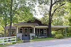 Clarence Frauenthal House |
November 19, 1993 (#93001256) |
210 N. Broadway St. 35°29′36″N 92°01′40″W |
Heber Springs | |
| 8 | O.D. Gunn Trade and Sale Barn |  O.D. Gunn Trade and Sale Barn |
June 7, 2016 (#16000316) |
10 Anna St. 35°22′59″N 92°12′58″W |
Quitman | |
| 9 | Heber Springs Commercial Historic District | 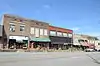 Heber Springs Commercial Historic District |
May 1, 2009 (#09000266) |
100 and 200 blocks of E. Main St., 100-500 blocks of W. Main St., 100 block of N. and S. 3rd, and N. and S. 4th Sts. 35°29′29″N 92°01′46″W |
Heber Springs | |
| 10 | Hugh L. King House | 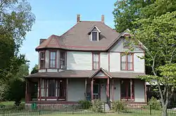 Hugh L. King House |
September 8, 1992 (#92001224) |
110 W. Spring St. 35°29′34″N 92°01′47″W |
Heber Springs | |
| 11 | Old Highway 16 Bridge | 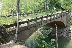 Old Highway 16 Bridge |
May 11, 2011 (#11000262) |
Lakefront Resort Rd. 35°36′09″N 92°11′18″W |
Edgemont vicinity | |
| 12 | T.E. Olmstead & Son Funeral Home | 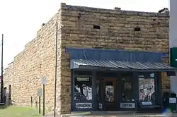 T.E. Olmstead & Son Funeral Home |
December 13, 1995 (#95001438) |
108 S. 4th St. 35°29′29″N 92°01′58″W |
Heber Springs | |
| 13 | Quitman Home Economics Building |  Quitman Home Economics Building |
September 4, 1992 (#92001127) |
2nd Ave. 35°22′47″N 92°13′17″W |
Quitman | |
| 14 | Rector House |  Rector House |
October 17, 2008 (#08000486) |
603 W. Quitman St. 35°29′23″N 92°02′07″W |
Heber Springs | |
| 15 | Shaheen-Goodfellow Weekend Cottage | 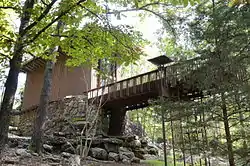 Shaheen-Goodfellow Weekend Cottage |
October 30, 2002 (#97000854) |
704 Stony Ridge 35°30′00″N 92°06′30″W |
Eden Isle | Designed by architect E. Fay Jones, also known as Stoneflower. |
| 16 | Woman's Community Club Band Shell |  Woman's Community Club Band Shell |
August 16, 1994 (#94000849) |
Northeastern corner of Spring Park 35°29′34″N 92°01′33″W |
Heber Springs | |
| 17 | Woodrow Store |  Woodrow Store |
January 4, 2001 (#00001592) |
Highway 263 35°39′47″N 92°04′48″W |
Woodrow |
Former listings
| [3] | Name on the Register | Image | Date listed | Date removed | Location | City or town | Summary |
|---|---|---|---|---|---|---|---|
| 1 | Quitman High School Building | September 4, 1992 (#92001126) | May 15, 2003 | AR 25 |
Quitman | ||
| 2 | Winkley Bridge | October 9, 1984 (#84000020) | August 11, 1999 | E of Heber Springs at Little Red River |
Heber Springs | Collapsed in 1989 |
See also
| Wikimedia Commons has media related to National Register of Historic Places in Cleburne County, Arkansas. |
References
- The latitude and longitude information provided in this table was derived originally from the National Register Information System, which has been found to be fairly accurate for about 99% of listings. Some locations in this table may have been corrected to current GPS standards.
- "National Register of Historic Places: Weekly List Actions". National Park Service, United States Department of the Interior. Retrieved on February 5, 2021.
- Numbers represent an alphabetical ordering by significant words. Various colorings, defined here, differentiate National Historic Landmarks and historic districts from other NRHP buildings, structures, sites or objects.
- "National Register Information System". National Register of Historic Places. National Park Service. March 13, 2009.
- The eight-digit number below each date is the number assigned to each location in the National Register Information System database, which can be viewed by clicking the number.
| Topics | |
|---|---|
| Lists by state |
|
| Lists by insular areas | |
| Lists by associated state | |
| Other areas | |
| Related | |
| |
Municipalities and communities of Cleburne County, Arkansas, United States | ||
|---|---|---|
| Cities | Map of Arkansas highlighting Cleburne County | |
| Towns | ||
| CDP | ||
| Unincorporated communities | ||
| Footnotes | ‡This populated place also has portions in an adjacent county or counties | |
| ||
This article is issued from Wikipedia. The text is licensed under Creative Commons - Attribution - Sharealike. Additional terms may apply for the media files.