National Register of Historic Places listings in Johnson County, Arkansas
This is a list of the National Register of Historic Places listings in Johnson County, Arkansas.
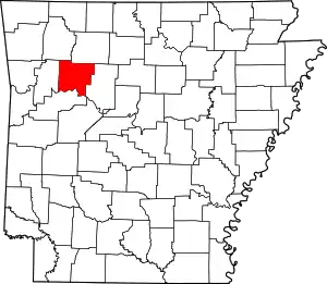
Location of Johnson County in Arkansas
This is intended to be a complete list of the properties on the National Register of Historic Places in Johnson County, Arkansas, United States. The locations of National Register properties for which the latitude and longitude coordinates are included below, may be seen in a map.[1]
There are 33 properties listed on the National Register in the county.
- This National Park Service list is complete through NPS recent listings posted February 5, 2021.[2]
Current listings
| [3] | Name on the Register[4] | Image | Date listed[5] | Location | City or town | Description |
|---|---|---|---|---|---|---|
| 1 | Big Piney Creek Bridge | 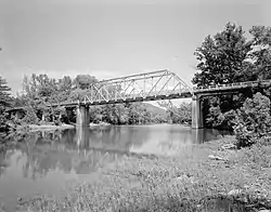 Big Piney Creek Bridge |
April 9, 1990 (#90000506) |
Highway 123 over Big Piney Creek 35°40′37″N 93°14′10″W |
Hagarville | |
| 2 | Bunch-Walton Post #22 American Legion Hut | 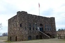 Bunch-Walton Post #22 American Legion Hut |
January 24, 2007 (#06001269) |
201 Legion St. 35°28′17″N 93°27′29″W |
Clarksville | |
| 3 | Clarksville Commercial Historic District |  Clarksville Commercial Historic District |
March 30, 2009 (#08000816) |
Roughly bounded by McConnell Street on the south, Cherry Street on the north, Johnson Street on the west, and Spadra Creek on the east 35°28′16″N 93°27′59″W |
Clarksville | |
| 4 | Clarksville Confederate Monument | 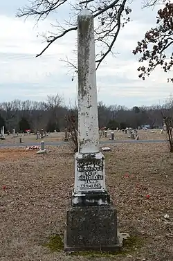 Clarksville Confederate Monument |
June 25, 1999 (#99000709) |
Oakland Memorial Cemetery, west of Montgomery Ave. 35°28′04″N 93°28′39″W |
Clarksville | |
| 5 | Clarksville High School Building No. 1 | September 10, 1992 (#92001202) |
Main St. 35°28′17″N 93°28′20″W |
Clarksville | Demolished | |
| 6 | Clarksville National Guard Armory | 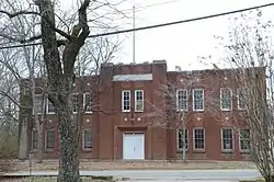 Clarksville National Guard Armory |
January 24, 2007 (#06001270) |
309 College St. 35°28′27″N 93°28′00″W |
Clarksville | |
| 7 | Davis House | 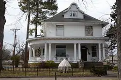 Davis House |
December 22, 1982 (#82000854) |
212 Fulton St. 35°28′01″N 93°27′57″W |
Clarksville | |
| 8 | N.E. Dickerson Store |  N.E. Dickerson Store |
September 22, 1995 (#95001124) |
East of Highway 215 35°41′21″N 93°34′23″W |
Oark | |
| 9 | Dover to Clarksville Road-Hickeytown Road Segment | 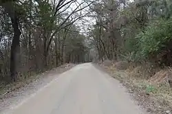 Dover to Clarksville Road-Hickeytown Road Segment |
May 26, 2005 (#05000464) |
Hickeytown Rd., east of U.S. Route 64 35°26′06″N 93°22′53″W |
Lamar | |
| 10 | Dunlap House | 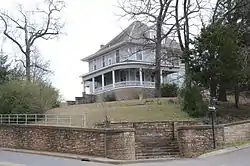 Dunlap House |
December 22, 1982 (#82000855) |
101 Grandview 35°28′15″N 93°27′37″W |
Clarksville | |
| 11 | First Presbyterian Church | 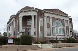 First Presbyterian Church |
May 13, 1991 (#91000588) |
212 College Ave. 35°28′21″N 93°27′57″W |
Clarksville | |
| 12 | Harmony Presbyterian Church | 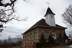 Harmony Presbyterian Church |
December 1, 1994 (#94001411) |
Northern side of Highway 103, approximately 8 miles north of Clarksville 35°33′02″N 93°34′13″W |
Harmony | |
| 13 | Taylor Hill Hotel | 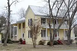 Taylor Hill Hotel |
October 21, 2008 (#08001007) |
409 Alabama St. 35°26′11″N 93°40′15″W |
Coal Hill | |
| 14 | Johnson County Courthouse | 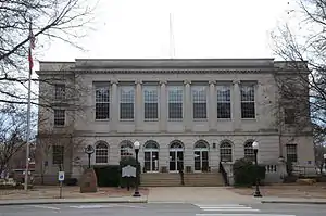 Johnson County Courthouse |
June 14, 1991 (#91000680) |
Junction of Main and Fulton Sts. 35°28′15″N 93°27′53″W |
Clarksville | |
| 15 | King's Canyon Petroglyphs | May 4, 1982 (#82002119) |
Address Restricted |
Clarksville | ||
| 16 | MacLean Hall | 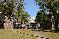 MacLean Hall |
June 5, 2017 (#100001008) |
415 N. College Ave. 35°28′33″N 93°27′59″W |
Clarksville | Residence hall at the University of the Ozarks. |
| 17 | Edward Taylor McConnell House |  Edward Taylor McConnell House |
May 10, 2001 (#01000485) |
302 S. Fulton St. 35°28′09″N 93°27′57″W |
Clarksville | |
| 18 | McKennon House | 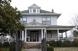 McKennon House |
December 22, 1982 (#82000856) |
115 Grandview 35°28′12″N 93°27′37″W |
Clarksville | |
| 19 | Capt. Archibald S. McKennon House |  Capt. Archibald S. McKennon House |
January 2, 1976 (#76000424) |
215 N. Central 35°28′22″N 93°27′55″W |
Clarksville | |
| 20 | Missouri-Pacific Depot-Clarksville | 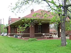 Missouri-Pacific Depot-Clarksville |
June 11, 1992 (#92000604) |
West of College St. between Cherry and Main Sts. 35°28′18″N 93°28′07″W |
Clarksville | |
| 21 | Munger House | 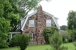 Munger House |
November 8, 1996 (#96001174) |
West of County Road 416, approximately ¾ mile north of the Pope County line 35°28′35″N 93°15′02″W |
Lutherville | |
| 22 | Raymond Munger Memorial Chapel-University of the Ozarks | 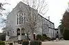 Raymond Munger Memorial Chapel-University of the Ozarks |
June 8, 1993 (#93000489) |
West of Highway 103 on the University of the Ozarks campus 35°28′38″N 93°28′03″W |
Clarksville | |
| 23 | Oark School-Methodist Church | September 29, 1995 (#95001142) |
Junction of Highway 215 and County Road 34 35°41′28″N 93°34′16″W |
Oark | ||
| 24 | Ozone School | 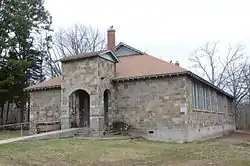 Ozone School |
January 27, 2015 (#14001200) |
14137 AR 21 35°37′51″N 93°26′34″W |
Ozone | |
| 25 | Pennington House |  Pennington House |
December 1, 1994 (#94001416) |
317 Johnson St. 35°28′23″N 93°28′09″W |
Clarksville | |
| 26 | Pioneer House | 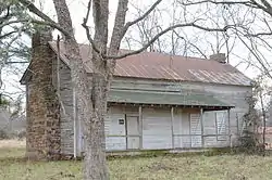 Pioneer House |
March 31, 1995 (#95000363) |
Poplar St. (U.S. Highway 64), south of Highway 123 and west of the Johnson County Hospital 35°27′47″N 93°26′47″W |
Clarksville | |
| 27 | St. Paul Lutheran School |  St. Paul Lutheran School |
March 5, 1999 (#99000228) |
County Road 418 35°28′44″N 93°16′52″W |
Lamar | |
| 28 | Serpent Cave | May 4, 1982 (#82002120) |
Address Restricted |
Clarksville | ||
| 29 | Fremont Stokes House | 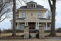 Fremont Stokes House |
June 4, 2008 (#08000488) |
319 Grandview Ave. 35°27′58″N 93°27′47″W |
Clarksville | |
| 30 | Tankersley-Stewart House | May 19, 1994 (#94000464) |
East of County Road 27 and north of Highway 352 35°29′26″N 93°36′36″W |
Hunt | Demolished. | |
| 31 | Union School | 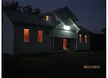 Union School |
January 24, 2011 (#10001150) |
North side of County Road 4670, west of Little Piney Creek 35°38′04″N 93°19′43″W |
Hagarville vicinity | Public Schools in the Ozarks MPS; two-room, wood frame schoolhouse erected in 1929; also used as a Masonic Lodge, church and community center[6] |
| 32 | U.S. 64 Horsehead Creek Bridge | 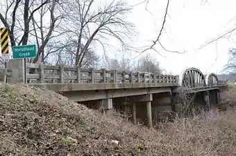 U.S. 64 Horsehead Creek Bridge |
September 29, 2014 (#14000792) |
US 64 over Horsehead Cr. 35°26′06″N 93°36′22″W |
Hartman | |
| 33 | Voorhees School | September 11, 2018 (#100002948) |
415 N College Ave. 35°28′34″N 93°27′59″W |
Clarksville |
Former listings
| [3] | Name on the Register | Image | Date listed | Date removed | Location | City or town | Summary |
|---|---|---|---|---|---|---|---|
| 1 | Science Hall, University of the Ozarks | January 21, 1993 (#92001830) | May 15, 2003 | University of the Ozarks campus, W of AR 103 |
Clarksville |
See also
| Wikimedia Commons has media related to National Register of Historic Places in Johnson County, Arkansas. |
References
- The latitude and longitude information provided in this table was derived originally from the National Register Information System, which has been found to be fairly accurate for about 99% of listings. Some locations in this table may have been corrected to current GPS standards.
- "National Register of Historic Places: Weekly List Actions". National Park Service, United States Department of the Interior. Retrieved on February 5, 2021.
- Numbers represent an alphabetical ordering by significant words. Various colorings, defined here, differentiate National Historic Landmarks and historic districts from other NRHP buildings, structures, sites or objects.
- "National Register Information System". National Register of Historic Places. National Park Service. March 13, 2009.
- The eight-digit number below each date is the number assigned to each location in the National Register Information System database, which can be viewed by clicking the number.
- Lanning, Curt (February 16, 2011). "Johnson County school declared historic property". Couriernews.com. Russellville, Arkansas: Russellville Newspapers, Inc. Retrieved February 17, 2011.
| Topics | |
|---|---|
| Lists by state |
|
| Lists by insular areas | |
| Lists by associated state | |
| Other areas | |
| Related | |
| |
Municipalities and communities of Johnson County, Arkansas, United States | ||
|---|---|---|
| Cities | Map of Arkansas highlighting Johnson County | |
| Town | ||
| CDP | ||
| Unincorporated communities | ||
| ||
This article is issued from Wikipedia. The text is licensed under Creative Commons - Attribution - Sharealike. Additional terms may apply for the media files.