National Register of Historic Places listings in Columbia County, Arkansas
This is a list of the National Register of Historic Places listings in Columbia County, Arkansas.
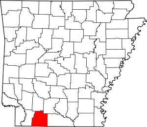
Location of Columbia County in Arkansas
This is intended to be a complete list of the properties and districts on the National Register of Historic Places in Columbia County, Arkansas, United States. The locations of National Register properties and districts for which the latitude and longitude coordinates are included below, may be seen in a map.[1]
There are 21 properties and districts listed on the National Register in the county.
- This National Park Service list is complete through NPS recent listings posted February 5, 2021.[2]
Current listings
| [3] | Name on the Register[4] | Image | Date listed[5] | Location | City or town | Description |
|---|---|---|---|---|---|---|
| 1 | W. H. Allen House | 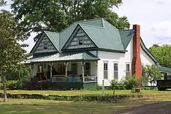 W. H. Allen House |
October 14, 1976 (#76000395) |
Northwest of Spotville off Highway 98 33°11′31″N 93°01′25″W |
Spotville | |
| 2 | Columbia County Courthouse | 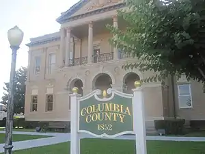 Columbia County Courthouse |
April 15, 1978 (#78000580) |
Court Sq. 33°16′01″N 93°14′27″W |
Magnolia | |
| 3 | Columbia County Jail |  Columbia County Jail |
December 22, 1982 (#82000802) |
Calhoun and Jefferson Sts. 33°15′55″N 93°14′30″W |
Magnolia | |
| 4 | Harvey C. Couch School | 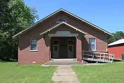 Harvey C. Couch School |
June 8, 1993 (#93000482) |
Northeast of the junction of County Roads 11 (Calhoun Rd.) and 25 33°13′12″N 93°09′12″W |
Calhoun | |
| 5 | Couch-Marshall House | 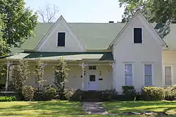 Couch-Marshall House |
July 24, 1992 (#92000955) |
505 W. Monroe St. 33°15′56″N 93°14′41″W |
Magnolia | |
| 6 | Cross and Nelson Hall Historic District | 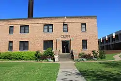 Cross and Nelson Hall Historic District |
January 20, 2010 (#09001240) |
Southern Arkansas University campus at 100 E. University 33°17′25″N 93°14′07″W |
Magnolia | |
| 7 | Dolph Camp, Bussey and Peace Halls Historic District | 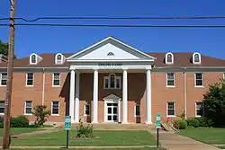 Dolph Camp, Bussey and Peace Halls Historic District |
January 29, 2013 (#12001231) |
East side of Lane Dr., Southern Arkansas University 33°17′26″N 93°14′03″W |
Magnolia | |
| 8 | Frog Level | 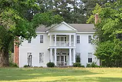 Frog Level |
September 22, 1972 (#72000201) |
West of Magnolia off Columbia Rd.[6] 33°16′44″N 93°21′13″W |
Bussey | |
| 9 | Greek Amphitheatre | 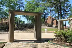 Greek Amphitheatre |
June 1, 2005 (#05000488) |
Junction of East Lane Dr., E. University St., and Crescent Dr. 33°17′27″N 93°14′04″W |
Magnolia | |
| 10 | Dr. H.A. Longino House | 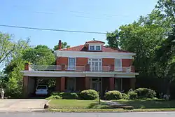 Dr. H.A. Longino House |
June 14, 1982 (#82002098) |
317 W. Main St. 33°16′00″N 93°14′36″W |
Magnolia | |
| 11 | Magnolia Colored School Historic District | 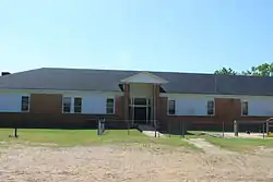 Magnolia Colored School Historic District |
January 22, 2014 (#13001103) |
611 S. Madison 33°15′43″N 93°14′37″W |
Magnolia | |
| 12 | Magnolia Commercial Historic District |  Magnolia Commercial Historic District |
May 20, 2008 (#08000435) |
Roughly bounded by Madison Ave., Calhoun St., Jackson Ave., and Union St. 33°16′02″N 93°14′27″W |
Magnolia | |
| 13 | Mt. Prospect Methodist Church | 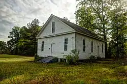 Mt. Prospect Methodist Church |
March 22, 1990 (#90000428) |
Junction of County Roads 61 and 446 33°22′09″N 93°04′32″W |
Richland | |
| 14 | Old Alexander House | 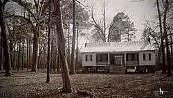 Old Alexander House |
January 18, 1979 (#79000435) |
Southern Arkansas University campus 33°19′24″N 93°08′26″W |
Magnolia | Moved from a rural setting in 2017. |
| 15 | Overstreet Hall |  Overstreet Hall |
January 26, 2016 (#15000992) |
NW. of jct. of E. University & N. Jackson Sts., Southern Arkansas University campus 33°17′23″N 93°14′10″W |
Magnolia | |
| 16 | Ozmer House | 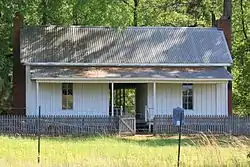 Ozmer House |
November 20, 1986 (#86003226) |
Southern Arkansas University farm, U.S. Route 82 Bypass 33°17′16″N 93°13′13″W |
Magnolia vicinity | |
| 17 | President's House |  President's House |
May 28, 2013 (#13000315) |
East Farm Road east of Washington Street, Southern Arkansas University 33°17′45″N 93°13′59″W |
Magnolia | |
| 18 | The Rushton Clinic | 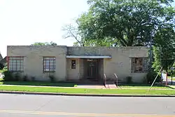 The Rushton Clinic |
May 28, 2013 (#13000316) |
219 North Washington Street 33°16′09″N 93°14′26″W |
Magnolia | |
| 19 | William H. Smith House | 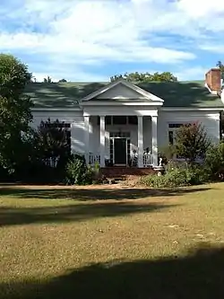 William H. Smith House |
November 27, 1992 (#92001630) |
North of the junction of Highway 98 and County Road 85 33°07′12″N 93°03′12″W |
Atlanta | |
| 20 | Kate Turner House | 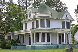 Kate Turner House |
August 26, 1982 (#82002099) |
709 W. Main St. 33°16′00″N 93°14′53″W |
Magnolia | |
| 21 | Waldo Water Tower | 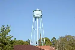 Waldo Water Tower |
May 29, 2007 (#07000472) |
E. Main St., west of its junction with N. Skimmer 33°21′11″N 93°16′56″W |
Waldo |
Former listings
| [3] | Name on the Register | Image | Date listed | Date removed | Location | City or town | Summary |
|---|---|---|---|---|---|---|---|
| 1 | Bank of Waldo | 1982 (#82000801) | September 17, 1999 | Locust and Main Sts. |
Waldo | ||
| 2 | Caraway Hall | 1993 (#93000088) | August 11, 1999 | Southern Arkansas University, Adjacent to E. Lane Dr. |
Magnolia | ||
| 3 | Louisiana and Northwest Railroad Depot - Magnolia | 1993 (#92000614) | March 31, 2000 | N side of Main St., between Clay and Walnut Sts. |
Magnolia |
See also
| Wikimedia Commons has media related to National Register of Historic Places in Columbia County, Arkansas. |
References
- The latitude and longitude information provided in this table was derived originally from the National Register Information System, which has been found to be fairly accurate for about 99% of listings. Some locations in this table may have been corrected to current GPS standards.
- "National Register of Historic Places: Weekly List Actions". National Park Service, United States Department of the Interior. Retrieved on February 5, 2021.
- Numbers represent an alphabetical ordering by significant words. Various colorings, defined here, differentiate National Historic Landmarks and historic districts from other NRHP buildings, structures, sites or objects.
- "National Register Information System". National Register of Historic Places. National Park Service. March 13, 2009.
- The eight-digit number below each date is the number assigned to each location in the National Register Information System database, which can be viewed by clicking the number.
- Location derived from NRIS-provided coords; the NRIS lists the site as "Address unknown at this time".
| Topics | |
|---|---|
| Lists by state |
|
| Lists by insular areas | |
| Lists by associated state | |
| Other areas | |
| Related | |
| |
Municipalities and communities of Columbia County, Arkansas, United States | ||
|---|---|---|
| Cities | Map of Arkansas highlighting Columbia County | |
| Town | ||
| Unincorporated communities | ||
| ||
This article is issued from Wikipedia. The text is licensed under Creative Commons - Attribution - Sharealike. Additional terms may apply for the media files.