National Register of Historic Places listings in Lafayette County, Arkansas
This is a list of the National Register of Historic Places listings in Lafayette County, Arkansas.
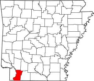
Location of Lafayette County in Arkansas
This is intended to be a complete list of the properties on the National Register of Historic Places in Lafayette County, Arkansas, United States. The locations of National Register properties for which the latitude and longitude coordinates are included below, may be seen in a map.[1]
There are 10 properties listed on the National Register in the county.
- This National Park Service list is complete through NPS recent listings posted February 5, 2021.[2]
Current listings
| [3] | Name on the Register[4] | Image | Date listed[5] | Location | City or town | Description |
|---|---|---|---|---|---|---|
| 1 | P.D. Burton House | 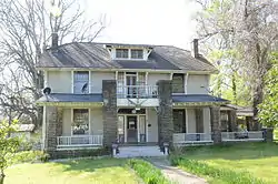 P.D. Burton House |
June 3, 1998 (#98000612) |
305 Chestnut 33°21′29″N 93°34′44″W |
Lewisville | |
| 2 | Conway Cemetery | 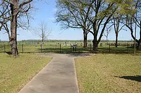 Conway Cemetery |
November 23, 1977 (#77000259) |
West of Bradley 33°06′11″N 93°41′02″W |
Bradley | |
| 3 | First Methodist Church |  First Methodist Church |
June 20, 1996 (#96000639) |
Northwestern corner of the junction of Chestnut and 4th Sts. 33°21′30″N 93°34′44″W |
Lewisville | |
| 4 | First Presbyterian Church |  First Presbyterian Church |
June 20, 1996 (#96000640) |
Southwestern corner of the junction of Market and Church Sts. 33°21′42″N 93°29′40″W |
Stamps | |
| 5 | Gulf Oil Company Filling Station | January 24, 2019 (#100003331) |
131 Main St. 33°21′48″N 93°30′03″W |
Stamps | ||
| 6 | King-Whatley Building | 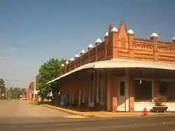 King-Whatley Building |
March 30, 1978 (#78000603) |
2nd and Maple Sts. 33°21′23″N 93°34′38″W |
Lewisville | |
| 7 | Lafayette County Courthouse |  Lafayette County Courthouse |
February 25, 1993 (#93000085) |
Bounded by 3rd, Spruce, 4th, and Maple Sts. 33°21′26″N 93°34′36″W |
Lewisville | |
| 8 | Lafayette County Training School | 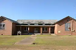 Lafayette County Training School |
January 20, 2005 (#04001500) |
1046 Berry St. 33°21′11″N 93°29′17″W |
Stamps | |
| 9 | Peoples Bank and Loan Building | 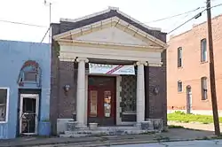 Peoples Bank and Loan Building |
June 20, 1996 (#96000637) |
Southwestern corner of the junction of Spruce and 3rd Sts. 33°21′24″N 93°34′39″W |
Lewisville | |
| 10 | Triplett Company Building | 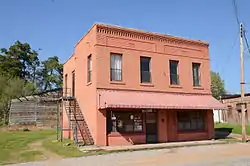 Triplett Company Building |
June 20, 1996 (#96000638) |
2nd St., west of its junction with Spruce St. 33°21′23″N 93°34′48″W |
Lewisville |
See also
| Wikimedia Commons has media related to National Register of Historic Places in Lafayette County, Arkansas. |
References
- The latitude and longitude information provided in this table was derived originally from the National Register Information System, which has been found to be fairly accurate for about 99% of listings. Some locations in this table may have been corrected to current GPS standards.
- "National Register of Historic Places: Weekly List Actions". National Park Service, United States Department of the Interior. Retrieved on February 5, 2021.
- Numbers represent an alphabetical ordering by significant words. Various colorings, defined here, differentiate National Historic Landmarks and historic districts from other NRHP buildings, structures, sites or objects.
- "National Register Information System". National Register of Historic Places. National Park Service. March 13, 2009.
- The eight-digit number below each date is the number assigned to each location in the National Register Information System database, which can be viewed by clicking the number.
| Topics | |
|---|---|
| Lists by state |
|
| Lists by insular areas | |
| Lists by associated state | |
| Other areas | |
| Related | |
| |
Municipalities and communities of Lafayette County, Arkansas, United States | ||
|---|---|---|
| Cities | Map of Arkansas highlighting Lafayette County | |
| Town | ||
| Unincorporated communities | ||
| ||
This article is issued from Wikipedia. The text is licensed under Creative Commons - Attribution - Sharealike. Additional terms may apply for the media files.