National Register of Historic Places listings in Boone County, Arkansas
This is a list of the National Register of Historic Places listings in Boone County, Arkansas.
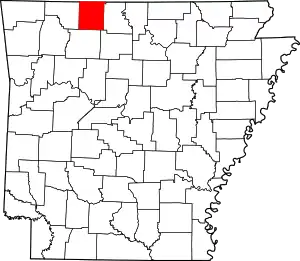
Location of Boone County in Arkansas
This is intended to be a complete list of the properties and districts on the National Register of Historic Places in Boone County, Arkansas, United States. The locations of National Register properties and districts for which the latitude and longitude coordinates are included below, may be seen in a map.[1]
There are 20 properties and districts listed on the National Register in the county.
- This National Park Service list is complete through NPS recent listings posted February 5, 2021.[2]
Current listings
| [3] | Name on the Register[4] | Image | Date listed[5] | Location | City or town | Description |
|---|---|---|---|---|---|---|
| 1 | Elliott and Anna Barham House | 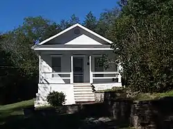 Elliott and Anna Barham House |
January 21, 2004 (#03001453) |
4085 West St. 36°17′02″N 92°54′58″W |
Zinc | |
| 2 | Bear Creek Motel | 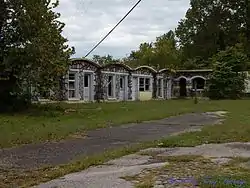 Bear Creek Motel |
March 13, 2001 (#01000175) |
U.S. Highway 65 36°17′30″N 93°10′55″W |
Bear Creek Springs | |
| 3 | Bergman High School | September 10, 1992 (#92001203) |
County Road 48 36°18′48″N 93°01′02″W |
Bergman | ||
| 4 | Boone County Courthouse |  Boone County Courthouse |
July 21, 1976 (#76000387) |
Courthouse Sq. 36°13′49″N 93°06′29″W |
Harrison | |
| 5 | Boone County Jail | December 12, 1976 (#76000388) |
Central Ave. and Willow St. 36°13′45″N 93°06′30″W |
Harrison | ||
| 6 | Carrollton Road-Carrollton Segment | May 20, 2008 (#08000432) |
County Road 917, Terrapin Creek Rd., and Dunkard Rd. between U.S. Highway 412 and Green Hill Rd. 36°16′05″N 93°17′13″W |
Carrollton | ||
| 7 | Cottonwood School #45 | October 4, 2002 (#02001078) |
Cottonwood and Dubuque Rd. 36°24′19″N 93°06′08″W |
Self | ||
| 8 | Cricket and Crest Tunnels Historic District | 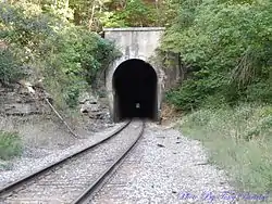 Cricket and Crest Tunnels Historic District |
September 19, 2007 (#07000954) |
Under and west of Old U.S. Highway 65 36°26′39″N 93°11′29″W |
Omaha | A pair of railroad tunnels either side of Omaha. |
| 9 | Duncan House | September 28, 2005 (#05001065) |
610 W. Central Ave. 36°13′52″N 93°06′53″W |
Harrison | ||
| 10 | Evans-Kirby House | 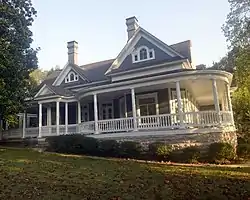 Evans-Kirby House |
January 20, 2005 (#04001505) |
611 S. Pine St. 36°13′33″N 93°06′40″W |
Harrison | |
| 11 | Everton School | 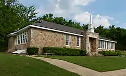 Everton School |
September 10, 1992 (#92001205) |
Main St. 36°09′12″N 92°54′25″W |
Everton | |
| 12 | Grubb Springs School |  Grubb Springs School |
March 29, 1996 (#96000329) |
Northeastern corner of the junction of Highways 43 and 397 36°13′12″N 93°08′59″W |
Harrison | |
| 13 | Haggard Ford Swinging Bridge | 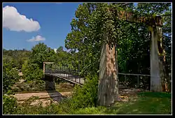 Haggard Ford Swinging Bridge |
June 30, 1995 (#95000790) |
Over Bear Creek at Cottonwood Rd., 8 miles north of Harrison 36°20′45″N 93°07′50″W |
Harrison | |
| 14 | Harrison Courthouse Square Historic District | 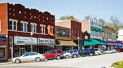 Harrison Courthouse Square Historic District |
May 6, 1999 (#99000523) |
Roughly bounded by N. Walnut, W. Ridge, N. Willow, and W. Stephenson Sts. 36°13′51″N 93°06′28″W |
Harrison | |
| 15 | Harrison High School |  Harrison High School |
January 24, 2007 (#06001284) |
124 S. Cherry St. 36°13′30″N 93°06′38″W |
Harrison | |
| 16 | Hotel Seville | 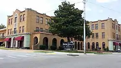 Hotel Seville |
May 19, 1994 (#94000443) |
Northwestern corner of the junction of Vine and Ridge Sts. 36°13′56″N 93°06′27″W |
Harrison | |
| 17 | Missouri and North Arkansas Depot-Bellefonte | June 11, 1992 (#92000601) |
Southeastern corner of the junction of Center St. and Keeter Dr. 36°12′10″N 93°02′47″W |
Bellefonte | ||
| 18 | Twelve Oaks | January 20, 2010 (#09001237) |
7210 Highway 7 South 36°10′00″N 93°07′23″W |
Harrison | ||
| 19 | Valley Springs School | .jpg.webp) Valley Springs School |
September 10, 1992 (#92001204) |
1 School St. 36°09′28″N 92°59′36″W |
Valley Springs | |
| 20 | Zinc Swinging Bridge-BO0162 | January 24, 2007 (#06001286) |
8039 Washington St. 36°17′05″N 92°54′55″W |
Zinc |
See also
| Wikimedia Commons has media related to National Register of Historic Places in Boone County, Arkansas. |
References
- The latitude and longitude information provided in this table was derived originally from the National Register Information System, which has been found to be fairly accurate for about 99% of listings. Some locations in this table may have been corrected to current GPS standards.
- "National Register of Historic Places: Weekly List Actions". National Park Service, United States Department of the Interior. Retrieved on February 5, 2021.
- Numbers represent an alphabetical ordering by significant words. Various colorings, defined here, differentiate National Historic Landmarks and historic districts from other NRHP buildings, structures, sites or objects.
- "National Register Information System". National Register of Historic Places. National Park Service. March 13, 2009.
- The eight-digit number below each date is the number assigned to each location in the National Register Information System database, which can be viewed by clicking the number.
| Topics | |
|---|---|
| Lists by state |
|
| Lists by insular areas | |
| Lists by associated state | |
| Other areas | |
| Related | |
| |
Municipalities and communities of Boone County, Arkansas, United States | ||
|---|---|---|
| Cities | Map of Arkansas highlighting Boone County | |
| Towns | ||
| Townships | ||
| Unincorporated communities | ||
| Ghost town | ||
| Footnotes | ‡This populated place also has portions in an adjacent county or counties | |
| ||
This article is issued from Wikipedia. The text is licensed under Creative Commons - Attribution - Sharealike. Additional terms may apply for the media files.