National Register of Historic Places listings in Howard County, Arkansas
This is a list of the National Register of Historic Places listings in Howard County, Arkansas.
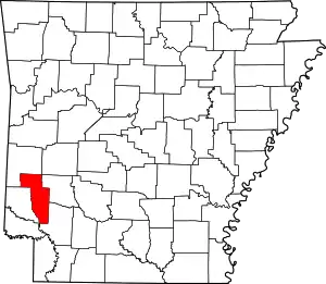
Location of Howard County in Arkansas
This is intended to be a complete list of the properties on the National Register of Historic Places in Howard County, Arkansas, United States. The locations of National Register properties for which the latitude and longitude coordinates are included below, may be seen in a map.[1]
There are 13 properties listed on the National Register in the county. Six other properties were once listed but have been removed.
- This National Park Service list is complete through NPS recent listings posted January 29, 2021.[2]
Current listings
| [3] | Name on the Register[4] | Image | Date listed[5] | Location | City or town | Description |
|---|---|---|---|---|---|---|
| 1 | Ebenezer Campground |  Ebenezer Campground |
March 26, 1976 (#76000416) |
North of Center Point off Highway 4 34°03′23″N 93°57′57″W |
Center Point | |
| 2 | First Presbyterian Church | 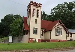 First Presbyterian Church |
May 4, 1976 (#76000418) |
2nd and Hempstead Sts. 33°56′33″N 93°50′54″W |
Nashville | |
| 3 | Garrett Whiteside Hall |  Garrett Whiteside Hall |
November 21, 1994 (#94001340) |
Southwestern corner of the junction of N. 3rd Ave. and Lockesburg St. 33°57′01″N 93°50′59″W |
Nashville | |
| 4 | Elbert W. Holt House | 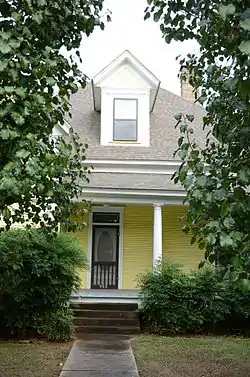 Elbert W. Holt House |
September 20, 1984 (#84000901) |
902 N. Main St. 33°57′35″N 93°51′11″W |
Nashville | |
| 5 | Flavius Holt House |  Flavius Holt House |
December 1, 1978 (#78000593) |
Kohler St. 33°57′05″N 93°50′39″W |
Nashville | |
| 6 | Howard County Courthouse | 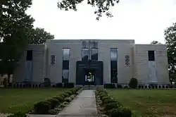 Howard County Courthouse |
June 14, 1990 (#90000902) |
Junction of N. Main St. and Bishop St. 33°56′52″N 93°50′51″W |
Nashville | |
| 7 | Memphis, Paris, and Gulf Depot |  Memphis, Paris, and Gulf Depot |
December 4, 1978 (#78000592) |
Highway 27 33°52′32″N 93°54′40″W |
Mineral Springs | |
| 8 | Mineral Springs Waterworks | 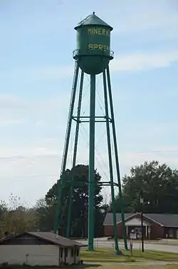 Mineral Springs Waterworks |
May 29, 2007 (#07000473) |
South of the junction of W. Runnels and S. Hall 33°52′30″N 93°55′17″W |
Mineral Springs | |
| 9 | Nashville American Legion Building | 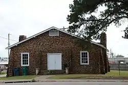 Nashville American Legion Building |
September 13, 1990 (#90001463) |
Highway 27, west of Main St. 33°56′01″N 93°51′01″W |
Nashville | |
| 10 | Nashville Commercial Historic District | 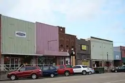 Nashville Commercial Historic District |
September 23, 2010 (#10000784) |
Bounded roughly by Shepherd St., Missouri Pacific Railroad, Hempstead St. and Second St. 33°56′38″N 93°50′50″W |
Nashville | |
| 11 | Nashville Post Office |  Nashville Post Office |
August 14, 1998 (#98000913) |
220 N. Main St. 33°56′43″N 93°50′46″W |
Nashville | |
| 12 | Old Corinth Cemetery |  Old Corinth Cemetery |
May 11, 2012 (#12000022) |
AR 26 34°02′39″N 93°50′24″W |
Center Point vicinity | |
| 13 | Womack-Parker House |  Womack-Parker House |
December 1, 1978 (#78000594) |
Off Highway 4 33°57′14″N 93°50′47″W |
Nashville |
Former listings
| [3] | Name on the Register | Image | Date listed | Date removed | Location | City or town | Summary |
|---|---|---|---|---|---|---|---|
| 1 | Adam Boyd House | May 13, 1976 (#76000415) | September 23, 2011 | East of Center Point on Highway 26 34°01′33″N 93°56′36″W |
Center Point | ||
| 2 | Clardy-Lee House | .tif.jpg.webp) Clardy-Lee House |
November 10, 1977 (#77000255) | September 23, 2011 | Highway 26 34°01′26″N 93°57′38″W |
Center Point | |
| 3 | DeQueen and Eastern Railroad Depot - Dierks | June 11, 1992 (#92000607) | March 31, 2000 | E of Herman Ave. |
Dierks | ||
| 4 | First Christian Church | November 4, 1982 (#82000831) | September 24, 2010 | N Main St. 33°56′55″N 93°50′47″W |
Nashville | ||
| 5 | Missouri Pacific Railroad Depot | June 11, 1992 (#92000618) | September 17, 1999 | S of E. Hempstead St., between S. Front and S. Ansley Sts. |
Nashville | ||
| 6 | Noel Owen Neal House | September 27, 2003 (#03000959) | January 26, 2006 | 184 S Blue Bayou Rd. 33°56′41″N 93°57′20″W |
Nashville | ||
| 7 | Russey-Murray House | May 4, 1976 (#76000417) | September 23, 2011 | South of Center Point on Highway 4 34°00′12″N 93°56′14″W |
Center Point | ||
| 8 | Tollette Shop Building | September 27, 2003 (#03000953) | May 28, 2010 | Town Hall Dr. 33°48′56″N 93°53′56″W |
Tollette |
See also
| Wikimedia Commons has media related to National Register of Historic Places in Howard County, Arkansas. |
References
- The latitude and longitude information provided in this table was derived originally from the National Register Information System, which has been found to be fairly accurate for about 99% of listings. Some locations in this table may have been corrected to current GPS standards.
- "National Register of Historic Places: Weekly List Actions". National Park Service, United States Department of the Interior. Retrieved on January 29, 2021.
- Numbers represent an alphabetical ordering by significant words. Various colorings, defined here, differentiate National Historic Landmarks and historic districts from other NRHP buildings, structures, sites or objects.
- "National Register Information System". National Register of Historic Places. National Park Service. March 13, 2009.
- The eight-digit number below each date is the number assigned to each location in the National Register Information System database, which can be viewed by clicking the number.
| Topics | |
|---|---|
| Lists by state |
|
| Lists by insular areas | |
| Lists by associated state | |
| Other areas | |
| Related | |
| |
Municipalities and communities of Howard County, Arkansas, United States | ||
|---|---|---|
| Cities | Map of Arkansas highlighting Howard County | |
| Town | ||
| Unincorporated communities | ||
| Ghost towns | ||
| ||
This article is issued from Wikipedia. The text is licensed under Creative Commons - Attribution - Sharealike. Additional terms may apply for the media files.