Pilibhit
Pilibhit is a city and a municipal board of Pilibhit district in the Indian state of Uttar Pradesh. Pilibhit is the north-easternmost district of Bareilly division, situated in the Rohilkhand region of the sub-Himalayan Plateau belt next to foothills of Sivalik Range on the boundary of Nepal, known for the origin of river Gomati and one of the most forest-rich areas in North India. Pilibhit was also known as Bansuri Nagari – the land of flutes, for making and exporting roughly 95 per cent of India's flutes.[2]
Pilibhit | |
|---|---|
City | |
 Pilibhit Location in Uttar Pradesh, India | |
| Coordinates: 28.6497°N 79.8724°E | |
| Country | |
| State | Uttar Pradesh |
| Region | Rohilkhand |
| Division | Bareilly |
| District | Pilibhit |
| Ward | 52 wards |
| Settled | Late 15th century |
| Government | |
| • Body | Nagar Palika Parisad Pilibhit |
| • Chairman | Vimla Jaiswal |
| • MP | Varun Sanjay Gandhi |
| • MLA | Sanjay Singh Gangwar |
| Area | |
| • Total | 16.32 km2 (6.30 sq mi) |
| Elevation | 172 m (564 ft) |
| Population (2011)[1] | |
| • Total | 127,988 |
| • Density | 559/km2 (1,450/sq mi) |
| Time zone | UTC+5:30 (IST) |
| PIN | 262001 |
| Telephone code | 05882 |
| ISO 3166 code | IN-UP-PB |
| Vehicle registration | UP-26 |
| Coastline | 0 kilometres (0 mi) |
| Sex ratio | 889 ♂/♀ |
| Literacy | 63.58% |
| Civic agency | Nagar Palika Parisad Pilibhit |
| Distance from Delhi | 274 kilometres (170 mi) NW (land) |
| Distance from Lucknow | 270 kilometres (170 mi) SE (land) |
| Governing body | Government of UP Government of India |
| Climate | HS-TH (Köppen) |
| Precipitation | 780 millimetres (31 in) |
| Avg. annual temperature | 25.5 °C (77.9 °F) |
| Avg. summer temperature | 36.8 °C (98.2 °F) |
| Avg. winter temperature | 14.5 °C (58.1 °F) |
| Website | www |
According to a report issued by the Government of India, Pilibhit is one of the Minority Concentrated Areas in India based on the 2001 census data on population, socio-economic indicators, and basic amenities indicators.[3] Though separated only by a short distance from the outer ranges of the Himalayas, Pilibhit consists entirely of a level plain, containing depressions but no hills and is intersected by several streams.[4] Pilibhit is one of the forest-rich areas of Uttar Pradesh, which has very high tourism potential. The almost 54 km-long Indo-Nepal international border makes Pilibhit a highly sensitive for security purposes.[5] According to an estimate by the Government of India, Pilibhit has 45.23% of its population living under the poverty line.[6] Increasing population and unemployment is a cause of worry in the area, and many non-governmental organizations (NGOs) and government-run organizations have initiated projects to provide employment, but human resources are yet to be exploited in full. The city came third-bottom in terms of hygiene and sanitation in a Government ranking list of 423 towns and cities in India.[7]
Pilibhit was in the news at the national level because of a few man-killer sub-adult tigers, which has caused fear in the whole area in and around the forest. By August 2010, the cat had killed and partially eaten eight people.[8]
Transportation
Pilibhit Junction railway station
Pilibhit Junction railway station is on the Izzatnagar-Tanakpur railway section. The station is under the administrative control of the North Eastern Railways.
Trains
- Shaktinagar Terminal–Tanakpur Express
- 15073/Singrauli - Tanakpur Triveni Express
- 14556/Delhi - Tanakpur Express
Pilibhit Depot (UPSRTC)
Pilibhit is well connected with UPSRTC busses. Bareilly , Tanakpur , Delhi , Lucknow , Dehradun , Haridwar , Agra , Mathura and various major cities of india is connected by State Transport UPSRTC buses. Some UPSRTC AC Shatabdi buses also run from Pilibhit to Delhi , Lucknow and Dehradun. Some UPSRTC 'buses run from Pilibhit to Shahjahanpur , Haldwani , Udham singh Nagar also. Connectivity via buses for these places are compratibly poor.
Pilibhit tiger reserve
Pilibhit Tiger Reserve is located in Pilibhit district, mahof range of Uttar Pradesh state in India. It lies along the India-Nepal border in the foothills of the Himalayas and the plains of the 'terai' in Uttar Pradesh. It is one of India's 50 Project Tiger Tiger reserves.
Pilibhit is one of the few well-forested districts in Uttar Pradesh. According to an estimate of the year 2004, Pilibhit district has over 800 km2 (310 sq mi) forests, constituting roughly 23% of the district's total area. Forests in Pilibhit have at least a good number of tigers and a good prey base for their survival as per records and assumption there were 36 tigers in 2016–17, then counts goes up till 45 in 2017–18, and present August 2019 to November 2020 there are 65 tigers in this reserve and more. Although some illegal human residents are still present in the reserve, the government is aiming to remove them. During winter, tigers could easily be seen in the countryside near forest areas. It holds a wide range of different animal and bird species.
History
Pilibhit forests area as a home for the striped cats, tiger, bear,and many species of bird. A proposal, created in 2005, to make a home for the endangered cats in Pilibhit forests was sent to the government of India in April 2008.[9] was declared in September 2008 based on its special type of ecosystem with vast open spaces and sufficient feed for the elegant predators.[10] The history of Pilibhit is very old. There used to be small kingdoms. One of them was based at Doria, about 15 km (9.3 mi) from Bisalpur Town. The legend that there was a Fort of King Bene Madhav in the dense forest of Deoria. During the freedom struggle, the rural folks showed Bravery. One freedom fighter Shri Bhadain Lal, Vill Rampur Amrit near Bilsanda who killed a British Police Inspector. He was jailed & imprisoned at Lalitpur Central Jail. The Britishers during the freedom struggle were chased out. They were given shelter by a few villagers at Mankapur. The Britishers in return offered them Land & Gardens near banks of Khannout River. In 1971-72 the Nank Matah damp leaked & flooded the Deoha River. Many lives were lost as the flood has taken place in odd hours.
Geography
The northeastern boundary of the reserve is the Sharda River (Nepali: Mahakali River) which defines the Indo-Nepal border, while the southwest boundary is marked by the River Sharda and the River Ghaghara. The reserve has a core zone area of 602.79 km2 (232.74 sq mi) and a buffer zone area of 127.45 km2 (49.21 sq mi). Elevation ranges from 168 to 175 meters above mean sea level.
Tourist Places
- Chuka Beach
- Pilibhit Tiger Reserve
- Bifercation
- Bhiramchari Ghaat

- Gauri Shankar Temple
- Yashvantri Temple
- Jama Masjid Pilibhit
- Dargah Shahji Mohammad Sher Miya
Town
Geography
Pilibhit lies between the parallels of 28°64' and 29°53' north latitude and the meridians of 79°57' and 81°37' east longitude covering an area of 68.76 km2. The north side of Pilibhit is bordered by Udham Singh Nagar of Uttarakhand state and by the territory of Nepal. Shahjahanpur lies on the south side Pilibhit. The east of Pilibhit is flanked for a short distance by Lakhimpur Kheri and the remaining distance is swathed by the Shahjahanpur. The western limit touches the limits of Bareilly.
According to the Central Statistical Organisation, the district Pilibhit had an area of 3504 km2 on 1 September 2007, occupying 46th position in the state and the total area of the Pilibhit city is 68.76 km2. Pilibhit city, with 2365.11 people per square kilometer, is more densely populated than the rest of the district, which has 469.51 people per km2.
The area has diverse features, and topographically may be divided into several distinct tracts. In the north and north-west, the tract is a continuation of the Terai. The southern portion of the Bisalpur tehsil is similar in most respect to the adjacent tract of Bareilly and Shahjahanpur. The eastern and smaller section approximates rather to undeveloped forest areas of Lakhimpur Kheri, though with the spread of cultivation the dissimilarity between Puranpur and the rest of the area is gradually becoming less marked. There are 1216 villages within Pilibhit's limits, of which 982 are electrified.[11]
The area has more than ten small to medium-sized rivers and nine small to medium-sized water bodies. The origin of river Gomti, Gumti or Gomati (Hindi: गोमती), which is a tributary of the Ganges River, is from a small lake, Gomat Taal, situated in Madhotanda in the Puranpur Tehsil region.[12] Pilibhit city also has a few water bodies in its limits, one being on Tanakpur road in front of the Dramond college gate, another being at the Chauraha degree college. Every year during winter, the Chauraha water body attracts thousands of migratory birds. The main source of water in the district is the groundwater and the canals. District Pilibhit is swathed by a big net of canals. The district has six main feeders or canals, which run through almost 138 km in the district.
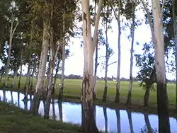
The major part of Pilibhit District is covered by dense forest. Total 784.572 km2 is forest.[13] Till 1978, 63% area of the district was a dense forest, but deforestation has reduced the total forest cover to 22.39% in 2004.[14] The Sharda canal is the main canal of the district, the others being its branches. The total length of canals in the district is 138 km. Apart from the canal system, the district also has a few water bodies, which are being used for agriculture purposes.
National Highway No. 74 runs through the district connecting Haridwar to Bareilly via Kichha, Kashipur and Nagina city. Apart from the National Highway, the district is well connected with Shahjahanpur in south, Lakhimpur Kheri and Indian International Border (IIB) with the Nepal in east, Nanital and town Khatima in north, and the city of Bareilly in the west by roads and railways.
The district Pilibhit also has several places of religious importance in or around the district. A main gurudwara of the Sikh community is located in Nanakmatta town around 46 km from the city.[15][16]
Demographics
As of the 2011 India census,[17] District Pilibhit had a population of 2,037,225. Pilibhit district is the 46th most populous Districts of Uttar Pradesh. Pilibhit City has 197,455 people. Males constitute 52.94% of the population and females 47.06%. Pilibhit has an average literacy rate of 63.58%, lower than the national average of 74.04%. Male literacy is 73.46%, and female literacy is 52.43%. In Pilibhit, 14.58% of the population is under 6 years of age.[18]
Studies reveal that the poverty level in the district is associated with the social identity, source of livelihood, landless and level of education of the head of the household. Education is a crucial instrument for raising income levels of people and moving out of the vicious circle of poverty. A study done by Delhi-based NGO, Nav Bharat Nirman indicates a strong correlation between educational attainment and poverty levels among various social classes in the district. The incidence of poverty is much higher among scheduled castes (SC) and scheduled tribes (ST) households in Pilibhit. Nearly 60 percent of SC households were below the poverty line in Pilibhit in 1999–2000. However, this proportion came down to 45.23 percent in 2007–08.[19]
Climate
Pilibhit experiences winter from November to February. It experiences pleasant windy days, clear skies and cool nights from November to the end of February. The day temperature hovers around 14 °C (57 °F) while night temperature is below 7 °C (45 °F) for most of December and January, often dropping to 3 °C (37 °F) or 4 °C (39 °F). Rain is very expected in February.[20]
Reported climatic variations:[21]
- The highest temperature recorded in Pilibhit was 48.5 °C (119 °F) on 29 May 1989.
- The lowest temperature recorded in Pilibhit was −1.2 °C (30 °F) on 17 January 1949.
| Climate data for Pilibhit, Uttar Pradesh, India | |||||||||||||
|---|---|---|---|---|---|---|---|---|---|---|---|---|---|
| Month | Jan | Feb | Mar | Apr | May | Jun | Jul | Aug | Sep | Oct | Nov | Dec | Year |
| Average high °C (°F) | 14 (57) |
19 (66) |
21 (70) |
36 (97) |
40 (104) |
42 (108) |
40 (104) |
36 (97) |
34 (93) |
29 (84) |
20 (68) |
11 (52) |
29 (83) |
| Average low °C (°F) | 4 (39) |
10 (50) |
13 (55) |
23 (73) |
31 (88) |
34 (93) |
32 (90) |
27 (81) |
24 (75) |
20 (68) |
13 (55) |
6 (43) |
20 (68) |
| Average rainfall mm (inches) | 7.6 (0.3) |
23 (0.9) |
30 (1.2) |
46 (1.8) |
81 (3.2) |
120 (4.8) |
130 (5.2) |
140 (5.5) |
110 (4.3) |
30 (1.2) |
23 (0.9) |
13 (0.5) |
753.6 (29.8) |
| Source: www.wunderground.com[22] | |||||||||||||
Etymology
According to the Imperial Gazetteer of India, Pilibhit was once known as Hafizabad after the Rohila leader of the area, Hafiz Rahmat Khan, but later took its current name from a nearby village.[23] According to a document from the British Library, 'the city Pilibhit' existed in the late 18th century (1770–1780) when Marathas invaded the Rohilkhand region. With this invasion, the Kurmi community came to this region and over time, the city Pilibhit enlarged it boundaries.[24]
Another evidence of the city's existence is found in Nepali literature, which mentions a city named as Pilibhit, which provided shelter to the last king of the Shah dynasty, Deepa Shah, who was attacked by the Gorakha king in 1789 AD.[25]
History
At the introduction of the British rule, the Parganas of Pilibhit, Jahanabad and Bisalpur was formed into separate tehsils. Puranpur was united for this purpose with Khutar. A redistribution of the area was affected in 1824 when the Bisalpur tehsil contained the Parganas of Bisalpur and Maurari, which afterward become a single area, Jahanabad was joined with Richha to form tehsil Pareva and Pilibhit with Baheri, the HQ being at Pilibhit. In 1851 Baheri and the other Tarai pargana were taken under direct management and in 1863 Richha was attached to the new Baheri tehsil, pargana Jahanabad being assigned to Pilibhit which also received Puranpur on its transfer in 1865. The latter, in 1871, a became sub tehsil dependent on Pilibhit. The promotion of Puranpur into a full tehsil occurred in 1879, while Bisalpur throughout remained a separate subdivision. Thus the area is now divided into three tehsils and four Parganas. Puranpur and Bisalpur constitute individual tehsils and Parganas and the tehsil of Pilibhit comprises the Parganas of Pilibhit and Jahanabad.[26]
Historical facts
It is believed by locals that Pilibhit was ruled by an ancient king named Mayurdhwaj or Moredhwaj or King Venu, a great devotee of lord Krishna and a loyal friend of Arjun. King Venu's name and the geography of his kingdom can be traced in the Hindu epic Mahabharat.[27]
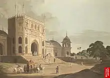
The city Pilibhit was an administrative unit in the Mughal era under Bareilly suba. For security, the Mughal subedar Ali Mohammed Khan constructed four magnificent gates around the administrative building in 1734 AD. These gates were named Barellwi Darwaza at the west, Hussaini Darwaza at the east, Jahanabadi Darwaza at the north and Dakhini Darwaza at the south. Because of a lack of proper maintenance, all the gates have been lost; only their ruins remain.[28]
The last king of the Shah dynasty of Doti, Nepal, Prithivipati Shah, was sheltered in Pilibhit by the ruler of Rampur suba Faizullah Khan in 1789 AD, after being attacked by the Gorakha king of Nepal.[29]
The freedom fighter Maulana Enayetulla, from Pilibhit, voluntarily played host to the exiled Queen of Avadh, Begum Hazrat Mahal, who reached Nepal in late 1859.[30][31]
Sports
Lalit Hari Sugar Factory Stadium
Lalit Hari Sugar Factory Stadium is mainly used for cricket. It was established in 1931. It has a matting type of pitch. This stadium had hosted a few Ranji trophy cricket matches in the early 1980s. Lalit Hari sugar factory stadium is located in the Shri Lalit Hari sugar mill compound.
Gandhi Stadium
This stadium is under control of Government. This stadium is mainly used for Hockey, Football, and Karate Training. This statidum is located on Gandhi Road so it is called Gandhi Stadium.
Various educational institutions have their Ground, including DGIC ground, St. Aloysius ground, Rama college ground, and SVM college ground. The City teams have produced many national level athletes who represented themselves at national tournaments and different events and have won a few state level and national level competitions on various events.[32]
Economy
The main crop in the district is sugarcane and there is a sugar factory in the city.[33] According to an article published in Hindustan Times, by a 1991 estimate, 95% of India's flutes were manufactured in Pilibhit.[34] The craftsmen were used to source its bamboo from Barak Valley in Assam. Earlier, there was an unbroken narrow-gauge line running from Silchar, in Assam, via Bihar, and into Pilibhit. On this line, 60-strong bundles of bamboo, each stalk 10 ft long, used to make their way to Pilibhit, but around 15 years ago, sections of that line were removed. Now, the bamboo has to travel on the narrow gauge from Silchar to Jiribum, then shift onto a broad-gauge line to travel to Bareilly, the nearest big town, and then reloaded onto narrow gauge to come into Pilibhit.[35] The soil in the rural area is known as Dumat. The wheat & rice yield is very high. The handlooms were established in the villages by local entrepreneurs in their houses but today because of mechanization no handlooms are visible. The rural folks work as labor in neighboring towns of Uttrakhand namely Rudrapur, Tankpur Khatima. The reason for the underdevelopment of the economy is poor transportation. Till today railway line is the main mode of communication. The goods transportation is done through road. Grain Merchants are the biggest traders in the area. These are concentrated in Pilibhit, Puranpur & Bisalpur towns.
Communication and media
Pilibhit has one local Radio Station (Akashwani) at 100.1 MHz but it also receives Bareilly's FM signals of following Radio providers:
| Service Provider | Frequency |
|---|---|
| All India Radio | 100.4 MHz |
| Big FM | 92.7 MHz |
| Radio Mantra | 91.9 MHz |
- Print media
The Hindi daily newspapers include Dainik Jagran, Amar Ujala, and The Hindustan. Prominent English dailies like The Times of India, The Hindustan Times and Indian Express have fewer readers. Among lesser-known Hindi papers are Swatantra Bharat, Rashtriya Sahara, and Jansatta. The Hindi newspapers Dainik Jagran and Amar Ujala have their offices in the city.
Politics
Lok Sabha Constituency
Vidhan Sabha constituencies
Civic administration
The Pilibhit Nagar Palika Parishad (PNPP) is the largest municipal board in the Pilibhit district, in charge of the civic and infrastructural assets of the city of Pilibhit. This municipal board was established in 1865.[36]
References
- "Census of India Search details". censusindia.gov.in. Retrieved 10 May 2015.
- "Pilibhit as Bansuri Nagari". The Indian Express. Retrieved 24 January 2010.
- "Minority Concentrated Districts". Government of India. Retrieved 19 December 2007.
- "The Physical Aspects". Government of India. Retrieved 4 October 2009.
- "Indo Nepal International Border". The Dainik Jagram, Hindi News Paper. Archived from the original on 18 July 2011. Retrieved 25 April 2009.
- "Population under poverty line". A N Sinha Institute of Social Studies. Archived from the original on 16 December 2013. Retrieved 21 July 2007.
- Government of India, National Urban Sanitation Policy
- "Man Eating Tiger". Time of India, English News Paper. 28 August 2010. Retrieved 29 August 2010.
- http://www.pib.nic.in/release/release.asp?relid=39098
- "Pilibhit tiger reserve gets Central nod | Lucknow News - Times of India".
- "Electrified Villages in Pilibhit". Uttar Pradesh Power Corporation Limited. Archived from the original on 31 March 2010. Retrieved 24 January 2010.
- Dikshit, Rajeev (25 August 2006). "Gomati goes missing". The Times of India. Retrieved 25 August 2006.
- "Forest in Pilibhit". District Administration. Archived from the original on 19 September 2008. Retrieved 3 December 2006.
- "Pilibhit Wildlife". SEVAK group, India. Archived from the original on 27 August 2011. Retrieved 23 April 2007.
- "Historic Gurdwara". Punjab Heritage. Retrieved 9 December 2008.
- "Nanak Matta Sahib". Uttarakhand Tourism. Retrieved 12 September 2006.
- "Population of Pilibhit" (PDF). National Register of Indian Citizens. Retrieved 7 May 2011.
- "The Literacy rate in 2011" (PDF). Government of India. Retrieved 7 May 2011.
- "Population Under Poverty Line". A N Sinha Institute of Social Studies. Archived from the original on 16 December 2013. Retrieved 21 July 2007.
- "Annual Weather Pilibhit". Weather Underground. Retrieved 22 October 2006.
- "Climatic Variations in Pilibhit". Indian Meteorological Department. Archived from the original on 20 March 2005. Retrieved 21 March 2005.
- "Pilibhit weather". Weather Underground. Retrieved 4 February 2008.
- "Pilibhit known as Hafizabad before 1763". Government of India. Retrieved 12 May 2009.
- "History of Banjaras". Prof Motiraj Rathod. Archived from the original on 7 June 2008. Retrieved 15 July 2008.
- "Advanced History of Nepal". T.R. Vaidya Publications. Archived from the original on 9 February 2005. Retrieved 20 January 2005.
- "History of Pilibhit". District Administration. Retrieved 29 September 2006.
- "Kingdom of King Venu". Government of India. Retrieved 12 May 2009.
- "Ruin of Pilibhit". Brill's Indological Library, Leiden: E.J. Brill. Retrieved 10 November 2007.
- "History of Nepal". T.R.Vaidya Publications. Archived from the original on 20 October 2006. Retrieved 31 January 2008.
- "History of Oudh". Najma Nasreen. Retrieved 12 February 2008.
- "History of Oudh and Pilibhit". Meerza Kaukab Qudr. Retrieved 12 February 2008.
- "Pilibhit city express". cities.expressindia.com. Retrieved 28 December 2007.
- "Sugar India" (PDF). CDM India. Archived from the original (PDF) on 10 April 2009. Retrieved 23 November 2008.
- "Flutes of Pilibhit". The Indian Express-News paper. Retrieved 22 April 2009.
- "History of flute". The Hindustan Times News Paper. Archived from the original on 25 January 2013. Retrieved 22 April 2009.
- "Municipal Board Establishment". Government of India. Retrieved 12 May 2009.
Further reading
- P. C. Kanjilal, P (1982). "A Forest Flora for Pilibhit, Oudh, Gorakhpur, and Bundelkhand" (5 ed.). Narendra Pub. House. Cite journal requires
|journal=(help) - Basil Leonard Clyde Johnson, P (1979). India,: Resources and Development (6 ed.). Heinemann Educational Books. ISBN 0-06-493348-2.
- Govt. of Uttar Pradesh, P (1959). "Uttar Pradesh District Gazetteers" (2 ed.). Govt. of Uttar Pradesh. Cite journal requires
|journal=(help) - Walter C. Neale, P (1962). "Economic Change in Rural India: Land Tenure and Reform in Uttar Pradesh:1800–1955" (1 ed.). Yale University Press. Cite journal requires
|journal=(help) - Ira Klein, P (1974). "Population and Agriculture in Northern India, 1872–1921" (1 ed.). Cambridge University Press. Cite journal requires
|journal=(help)
External links
- Official Web Site
- Pilibhit city guide
- Government Of Uttar Pradesh – Official Web Site
- Pilibhit Tiger Reserve
Places adjacent to Pilibhit | ||||||||||
|---|---|---|---|---|---|---|---|---|---|---|
| ||||||||||
Tiger reserves of India | |
|---|---|
| Assam |
|
| Arunachal Pradesh | |
| Andhra Pradesh | |
| Bihar | |
| Chhattisgarh | |
| Jharkhand | |
| Karnataka | |
| Kerala | |
| Madhya Pradesh | |
| Maharashtra | |
| Mizoram | |
| Odisha | |
| Rajasthan | |
| Tamil Nadu | |
| Telangana |
|
| Uttar Pradesh | |
| Uttarakhand | |
| West Bengal | |
| |
