National Register of Historic Places listings in Carter County, Tennessee
This is a list of the National Register of Historic Places listings in Carter County, Tennessee.
Location of Carter County in Tennessee
This is intended to be a complete list of the properties and districts on the National Register of Historic Places in Carter County, Tennessee, United States. Latitude and longitude coordinates are provided for many National Register properties and districts; these locations may be seen together in a map.[1]
There are 13 properties and districts listed on the National Register in the county, including 1 National Historic Landmark.
See also National Register of Historic Places listings in Washington County, Tennessee for additional properties in Johnson City, a city that spans the county line.
| Anderson – Bedford – Benton – Bledsoe – Blount – Bradley – Campbell – Cannon – Carroll – Carter – Cheatham – Chester – Claiborne – Clay – Cocke – Coffee – Crockett – Cumberland – Davidson – Decatur – DeKalb – Dickson – Dyer – Fayette – Fentress – Franklin – Gibson – Giles – Grainger – Greene – Grundy – Hamblen – Hamilton – Hancock – Hardeman – Hardin – Hawkins – Haywood – Henderson – Henry – Hickman – Houston – Humphreys – Jackson – Jefferson – Johnson – Knox – Lake – Lauderdale – Lawrence – Lewis – Lincoln – Loudon – Macon – Madison – Marion – Marshall – Maury – McMinn – McNairy – Meigs – Monroe – Montgomery – Moore – Morgan – Obion – Overton – Perry – Pickett – Polk – Putnam – Rhea – Roane – Robertson – Rutherford – Scott – Sequatchie – Sevier – Shelby – Smith – Stewart – Sullivan – Sumner – Tipton – Trousdale – Unicoi – Union – Van Buren – Warren – Washington – Wayne – Weakley – White – Williamson – Wilson |
- This National Park Service list is complete through NPS recent listings posted January 29, 2021.[2]
Current listings
| [3] | Name on the Register[4] | Image | Date listed[5] | Location | City or town | Description |
|---|---|---|---|---|---|---|
| 1 | Rueben Brooks Farmstead | 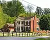 Rueben Brooks Farmstead |
April 5, 2001 (#01000344) |
1548 Blue Springs Rd. 36°23′46″N 82°06′25″W |
Elizabethton | Farm established c. 1820, house constructed during the same period. |
| 2 | John and Landon Carter House | 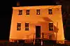 John and Landon Carter House |
April 14, 1972 (#72001230) |
1013 Broad St. 36°21′14″N 82°12′17″W |
Elizabethton | |
| 3 | Elizabethton Historic District | 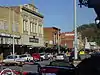 Elizabethton Historic District |
March 14, 1973 (#73001754) |
Bounded roughly by 2nd, 4th, East, and Sycamore Sts. 36°20′52″N 82°12′41″W |
Elizabethton | |
| 4 | Henson Hunt House | 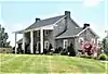 Henson Hunt House |
December 26, 1979 (#79002414) |
Brookdale Rd. 36°17′56″N 82°19′25″W |
Johnson City | |
| 5 | Miller Farmstead | July 25, 2014 (#14000449) |
Roan Mountain State Park 36°10′41″N 82°06′38″W |
Roan Mountain | ||
| 6 | Renfro-Allen Farm | March 28, 1996 (#96000333) |
Judge Ben Allen Rd., northeast of Elizabethton 36°22′37″N 82°10′48″W |
Elizabethton | ||
| 7 | Sabine Hill | 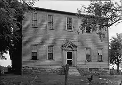 Sabine Hill |
April 11, 1973 (#73001755) |
Off State Route 67 36°19′33″N 82°16′11″W |
Elizabethton | |
| 8 | Shelving Rock Encampment | 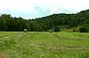 Shelving Rock Encampment |
July 10, 2009 (#09000533) |
State Route 143 and Smith Branch Rd. 36°11′00″N 82°04′32″W |
Roan Mountain | Site where the Overmountain Men camped in September 1780 while en route to the Battle of Kings Mountain. |
| 9 | Simerly-Butler House | 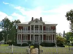 Simerly-Butler House |
November 7, 1996 (#96001315) |
206 Main St. 36°17′00″N 82°10′24″W |
Hampton | Now known as Butler Mansion; built in 1867 by local businessman and politician Elijah Simerly; later occupied by Ralph Butler. |
| 10 | Sycamore Shoals | .jpg.webp) Sycamore Shoals |
October 15, 1966 (#66000721) |
2 miles (3.2 km) west of Elizabethton on the Watauga River 36°20′33″N 82°15′21″W |
Elizabethton | |
| 11 | U.S. Post Office |  U.S. Post Office |
August 9, 1983 (#83003024) |
201-203 N. Sycamore St. 36°20′56″N 82°12′54″W |
Elizabethton | Early-1930s beaux-arts building designed by James Wetmore; now home to the Elizabethton-Carter County Public Library. |
| 12 | Watauga Hydroelectric Project |  Watauga Hydroelectric Project |
August 11, 2017 (#100001463) |
774 Wilbur Dam Rd. 36°19′24″N 82°07′19″W |
Elizabethton | |
| 13 | John T. Wilder House |  John T. Wilder House |
March 13, 1986 (#86000400) |
202 Main St. 36°11′45″N 82°04′16″W |
Roan Mountain | Built in 1884 by General John T. Wilder. |
Former listings
| [3] | Name on the Register | Image | Date listed | Date removed | Location | City or town | Summary |
|---|---|---|---|---|---|---|---|
| 1 | Carriger-Cowan House | June 6, 1979 (#79002415) | March 27, 2013 | East of Siam |
Siam | ||
| 2 | Henry Range House | March 25, 1982 (#82003956) | April 12, 1991 | South of Watauga on Smallings Rd. |
Watauga |
See also
| Wikimedia Commons has media related to National Register of Historic Places in Carter County, Tennessee. |
References
- The latitude and longitude information provided in this table was derived originally from the National Register Information System, which has been found to be fairly accurate for about 99% of listings. Some locations in this table may have been corrected to current GPS standards.
- "National Register of Historic Places: Weekly List Actions". National Park Service, United States Department of the Interior. Retrieved on January 29, 2021.
- Numbers represent an alphabetical ordering by significant words. Various colorings, defined here, differentiate National Historic Landmarks and historic districts from other NRHP buildings, structures, sites or objects.
- "National Register Information System". National Register of Historic Places. National Park Service. April 24, 2008.
- The eight-digit number below each date is the number assigned to each location in the National Register Information System database, which can be viewed by clicking the number.
| Topics | |
|---|---|
| Lists by state |
|
| Lists by insular areas | |
| Lists by associated state | |
| Other areas | |
| Related | |
| |
Municipalities and communities of Carter County, Tennessee, United States | ||
|---|---|---|
| Cities | ||
| CDPs | ||
| Unincorporated communities | ||
| Footnotes | ‡This populated place also has portions in an adjacent county or counties | |
| ||
This article is issued from Wikipedia. The text is licensed under Creative Commons - Attribution - Sharealike. Additional terms may apply for the media files.