National Register of Historic Places listings in Robertson County, Tennessee
This is a list of the National Register of Historic Places listings in Robertson County, Tennessee.
Location of Robertson County in Tennessee
This is intended to be a complete list of the properties and districts on the National Register of Historic Places in Robertson County, Tennessee, United States. Latitude and longitude coordinates are provided for many National Register properties and districts; these locations may be seen together in a map.[1]
There are 28 properties and districts listed on the National Register in the county.
| Anderson – Bedford – Benton – Bledsoe – Blount – Bradley – Campbell – Cannon – Carroll – Carter – Cheatham – Chester – Claiborne – Clay – Cocke – Coffee – Crockett – Cumberland – Davidson – Decatur – DeKalb – Dickson – Dyer – Fayette – Fentress – Franklin – Gibson – Giles – Grainger – Greene – Grundy – Hamblen – Hamilton – Hancock – Hardeman – Hardin – Hawkins – Haywood – Henderson – Henry – Hickman – Houston – Humphreys – Jackson – Jefferson – Johnson – Knox – Lake – Lauderdale – Lawrence – Lewis – Lincoln – Loudon – Macon – Madison – Marion – Marshall – Maury – McMinn – McNairy – Meigs – Monroe – Montgomery – Moore – Morgan – Obion – Overton – Perry – Pickett – Polk – Putnam – Rhea – Roane – Robertson – Rutherford – Scott – Sequatchie – Sevier – Shelby – Smith – Stewart – Sullivan – Sumner – Tipton – Trousdale – Unicoi – Union – Van Buren – Warren – Washington – Wayne – Weakley – White – Williamson – Wilson |
- This National Park Service list is complete through NPS recent listings posted February 5, 2021.[2]
Current listings
| [3] | Name on the Register[4] | Image | Date listed[5] | Location | City or town | Description |
|---|---|---|---|---|---|---|
| 1 | The Beeches | 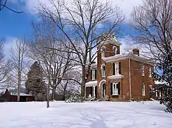 The Beeches |
March 25, 1982 (#82004037) |
State Route 49 36°31′15″N 86°51′18″W |
Springfield | |
| 2 | Bell Witch Cave | 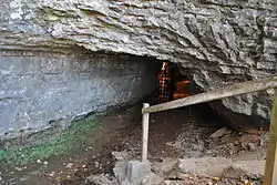 Bell Witch Cave |
March 21, 2008 (#08000237) |
430 Keysburg Rd. 36°35′29″N 87°03′20″W |
Adams | Associated with the legend of the Bell Witch |
| 3 | Cornsilk | Cornsilk |
January 11, 1974 (#74002266) |
North of Cross Plains on Highland Rd. 36°38′06″N 86°37′54″W |
Cross Plains | |
| 4 | Frierson Chapel | November 27, 2019 (#100004694) |
Approx. 0.20 mi. off Old Coopertown Rd. 36°26′11″N 86°57′44″W |
Coopertown | ||
| 5 | Glen Raven | .jpg.webp) Glen Raven |
October 2, 1973 (#73001816) |
Southwest of Cedar Hill on Washington Rd. 36°31′53″N 87°04′11″W |
Cedar Hill | |
| 6 | Mollie and Neel Glenn House | 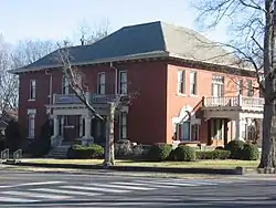 Mollie and Neel Glenn House |
July 25, 2012 (#12000440) |
307 5th Ave. 36°30′36″N 86°53′17″W |
Springfield | |
| 7 | Highland Chapel Union Church | 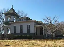 Highland Chapel Union Church |
October 29, 1991 (#91001592) |
Highland Ave. 36°23′42″N 86°46′30″W |
Ridgetop | |
| 8 | Mansfield Cheatham House | 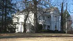 Mansfield Cheatham House |
January 30, 1978 (#78002626) |
7th Ave., W. 36°30′28″N 86°53′19″W |
Springfield | |
| 9 | William M. McMurry House | 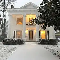 William M. McMurry House |
April 17, 2017 (#100000904) |
313 N. Main St. 36°30′44″N 86°53′04″W |
Springfield | |
| 10 | Nelson's Green Brier Distillery | 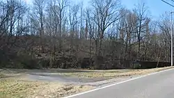 Nelson's Green Brier Distillery |
July 24, 2008 (#08000703) |
Main St. west of Greenbrier Cemetery Rd. 36°26′05″N 86°47′27″W |
Greenbrier | |
| 11 | George O'Bryan House | 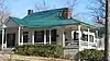 George O'Bryan House |
February 23, 1989 (#89000073) |
O'Bryan and Highland Aves. 36°23′43″N 86°46′23″W |
Ridgetop | |
| 12 | Arthur Pitt House and Distillery | 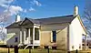 Arthur Pitt House and Distillery |
December 18, 1973 (#73001820) |
4333 Louis Dragon Rd. 36°32′36″N 86°48′50″W |
Springfield | |
| 13 | William Randolph House | 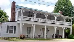 William Randolph House |
October 30, 1973 (#73001818) |
On State Route 25 36°32′54″N 86°41′52″W |
Cross Plains | |
| 14 | Red River Blockhouse Number 1 | November 15, 2003 (#03001157) |
5461 U.S. Route 41 36°35′22″N 87°04′58″W |
Adams | ||
| 15 | Robertson County Courthouse | 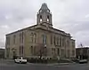 Robertson County Courthouse |
May 22, 1978 (#78002627) |
Public Sq. 36°30′33″N 86°53′07″W |
Springfield | |
| 16 | Rock Jolly | 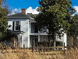 Rock Jolly |
October 30, 1973 (#73001819) |
5128 Rock House Rd. 36°34′44″N 86°37′23″W |
Cross Plains | |
| 17 | Russell House |  Russell House |
November 22, 2011 (#11000458) |
2520 Memorial Boulevard 36°29′22″N 86°51′53″W |
Springfield | |
| 18 | St. Michael's Catholic Church | 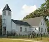 St. Michael's Catholic Church |
July 5, 1973 (#73001817) |
3.5 miles west of State Route 49 36°29′14″N 86°59′56″W |
Cedar Hill | |
| 19 | Springfield Town Square Historic District | 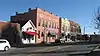 Springfield Town Square Historic District |
August 1, 1979 (#79002456) |
U.S. Route 41 and State Route 49 36°30′34″N 86°53′08″W |
Springfield | |
| 20 | Granville Babb Sprouse House | 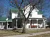 Granville Babb Sprouse House |
October 30, 1998 (#98001307) |
205 W. College St. 36°25′37″N 86°48′25″W |
Greenbrier | |
| 21 | Strickland Place Farm | 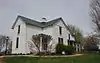 Strickland Place Farm |
March 31, 2010 (#10000142) |
7724-7726 Highway 76 East 36°28′35″N 86°42′27″W |
White House | |
| 22 | Sudley Place | 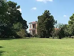 Sudley Place |
January 11, 1974 (#74001925) |
North of Youngfield on State Line Rd. 36°38′40″N 86°48′56″W |
Youngville | |
| 23 | Thomas Drugs | 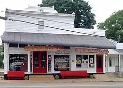 Thomas Drugs |
November 4, 1993 (#93001189) |
7802 State Route 25, E. 36°32′55″N 86°41′48″W |
Cross Plains | |
| 24 | Dr. Martin Walton House | 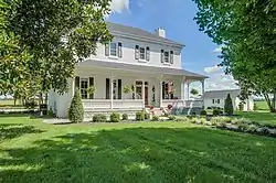 Dr. Martin Walton House |
November 20, 1996 (#96001318) |
6360 State Route 25, E. 36°33′14″N 86°47′09″W |
Springfield | |
| 25 | Walton-Wiggins Farm | 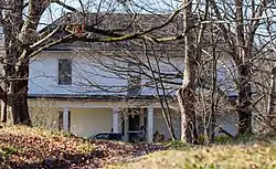 Walton-Wiggins Farm |
August 8, 1997 (#97000883) |
4020 Woodrow Wilson Rd. 36°31′12″N 86°44′05″W |
Springfield | |
| 26 | Wessyngton | Wessyngton |
May 6, 1971 (#71000830) |
South of Cedar Hill 36°30′05″N 87°00′14″W |
Cedar Hill | |
| 27 | Woodard Hall | 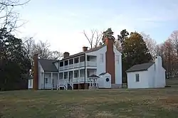 Woodard Hall |
October 10, 1975 (#75001775) |
Northeast of Springfield on Owens Chapel Rd.; also 5876 Owens Chapel Rd. 36°32′04″N 86°49′18″W |
Springfield | 5876 Owens Chapel represents a boundary increase of April 28, 1995 |
| 28 | Thomas Woodard, Jr. Farm | 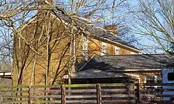 Thomas Woodard, Jr. Farm |
April 8, 2008 (#08000315) |
5024 Ogg Rd. 36°34′15″N 86°56′13″W |
Cedar Hill |
See also
| Wikimedia Commons has media related to National Register of Historic Places in Robertson County, Tennessee. |
References
- The latitude and longitude information provided in this table was derived originally from the National Register Information System, which has been found to be fairly accurate for about 99% of listings. Some locations in this table may have been corrected to current GPS standards.
- "National Register of Historic Places: Weekly List Actions". National Park Service, United States Department of the Interior. Retrieved on February 5, 2021.
- Numbers represent an alphabetical ordering by significant words. Various colorings, defined here, differentiate National Historic Landmarks and historic districts from other NRHP buildings, structures, sites or objects.
- "National Register Information System". National Register of Historic Places. National Park Service. April 24, 2008.
- The eight-digit number below each date is the number assigned to each location in the National Register Information System database, which can be viewed by clicking the number.
| Topics | |
|---|---|
| Lists by state |
|
| Lists by insular areas | |
| Lists by associated state | |
| Other areas | |
| Related | |
| |
Municipalities and communities of Robertson County, Tennessee, United States | ||
|---|---|---|
| Cities | ||
| Towns | ||
| Unincorporated communities | ||
| Footnotes | ‡This populated place also has portions in an adjacent county or counties | |
| ||
This article is issued from Wikipedia. The text is licensed under Creative Commons - Attribution - Sharealike. Additional terms may apply for the media files.