National Register of Historic Places listings in Blount County, Tennessee
This is a list of the National Register of Historic Places listings in Blount County, Tennessee.
Location of Blount County in Tennessee
This is intended to be a complete list of the properties and districts on the National Register of Historic Places in Blount County, Tennessee, United States. Latitude and longitude coordinates are provided for many National Register properties and districts; these locations may be seen together in a map.[1]
There are 76 properties and districts listed on the National Register in the county. Another 3 properties were previously listed but have been removed.
| Anderson – Bedford – Benton – Bledsoe – Blount – Bradley – Campbell – Cannon – Carroll – Carter – Cheatham – Chester – Claiborne – Clay – Cocke – Coffee – Crockett – Cumberland – Davidson – Decatur – DeKalb – Dickson – Dyer – Fayette – Fentress – Franklin – Gibson – Giles – Grainger – Greene – Grundy – Hamblen – Hamilton – Hancock – Hardeman – Hardin – Hawkins – Haywood – Henderson – Henry – Hickman – Houston – Humphreys – Jackson – Jefferson – Johnson – Knox – Lake – Lauderdale – Lawrence – Lewis – Lincoln – Loudon – Macon – Madison – Marion – Marshall – Maury – McMinn – McNairy – Meigs – Monroe – Montgomery – Moore – Morgan – Obion – Overton – Perry – Pickett – Polk – Putnam – Rhea – Roane – Robertson – Rutherford – Scott – Sequatchie – Sevier – Shelby – Smith – Stewart – Sullivan – Sumner – Tipton – Trousdale – Unicoi – Union – Van Buren – Warren – Washington – Wayne – Weakley – White – Williamson – Wilson |
- This National Park Service list is complete through NPS recent listings posted January 29, 2021.[2]
Current listings
| [3] | Name on the Register[4] | Image | Date listed[5] | Location | City or town | Description |
|---|---|---|---|---|---|---|
| 1 | John Alexander House |  John Alexander House |
July 25, 1989 (#89000864) |
714 Hillside Ave. 35°45′15″N 83°57′35″W |
Maryville | Built in 1906 by Maryville College alumnus John Alexander |
| 2 | Alumni Gym | 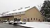 Alumni Gym |
July 25, 1989 (#89000865) |
Maryville College campus 35°45′01″N 83°57′55″W |
Maryville | Gymnasium built in 1923 |
| 3 | Anderson Hall | 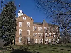 Anderson Hall |
February 20, 1975 (#75001732) |
Maryville College campus 35°45′08″N 83°57′54″W |
Maryville | |
| 4 | Peter Bartlett House | 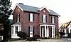 Peter Bartlett House |
July 25, 1989 (#89000866) |
315 High St. 35°45′20″N 83°58′02″W |
Maryville | |
| 5 | Bethlehem Methodist Church | 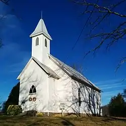 Bethlehem Methodist Church |
July 25, 1989 (#89000867) |
Bethlehem Rd., 0.5 miles south of Ellejoy Rd. 35°47′17″N 83°48′43″W |
Wildwood | |
| 6 | Brick Mill Site | July 25, 1989 (#89000868) |
Brick Mill Rd. 35°39′30″N 84°06′21″W |
Maryville | ||
| 7 | Peter Brickey House |  Peter Brickey House |
July 25, 1989 (#89000869) |
Wears Valley Rd., 0.1 miles west of Bonner Hollow Rd. 35°41′25″N 83°42′33″W |
Townsend | |
| 8 | Cades Cove Historic District | 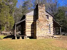 Cades Cove Historic District |
July 13, 1977 (#77000111) |
10 miles southwest of Townsend in Great Smoky Mountains National Park 35°35′13″N 83°48′54″W |
Townsend | |
| 9 | Calderwood Dam |  Calderwood Dam |
August 21, 1989 (#89001069) |
Little Tennessee River at the end of Calderwood Rd. 35°29′32″N 83°58′58″W |
Calderwood | Extends into Monroe County. The dam was listed in 1989; boundaries were increased on July 3, 1990 to include the powerhouse, valve house, tunnels, and penstocks. |
| 10 | Calderwood Hydroelectric Development | 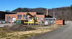 Calderwood Hydroelectric Development |
May 24, 2004 (#04000545) |
314 Growdon Boulevard 35°29′56″N 83°59′15″W |
Calderwood | This is a supplementary listing to the Calderwood Dam entry that added the complex's gatehouse, gantry cranes, surge tank, chlorination building, and service building, as well as a theater and school once used by the old Calderwood community. |
| 11 | Chilhowee Hydroelectric Development | 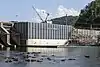 Chilhowee Hydroelectric Development |
May 27, 2004 (#04000546) |
6102 State Route 129 35°32′45″N 84°03′00″W |
Tallassee | |
| 12 | Langston Clark Barn | 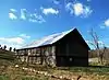 Langston Clark Barn |
July 25, 1989 (#89000870) |
Sixmile Rd., 0.4 miles east of Knob Creek Rd. 35°38′15″N 84°00′04″W |
Maryville | |
| 13 | Clover Hill Mill | 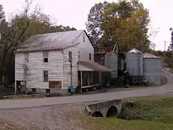 Clover Hill Mill |
July 25, 1989 (#89000871) |
Junction of Mill Rd. and Clover Hill Rd. 35°42′15″N 84°03′01″W |
Maryville | |
| 14 | Cloyd's Creek Presbyterian Church | 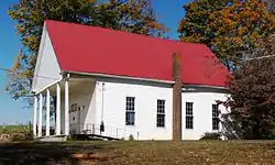 Cloyd's Creek Presbyterian Church |
July 25, 1989 (#89000873) |
Junction of Buzzard's Roost Rd. and Kirk Rd. 35°41′52″N 84°09′37″W |
Friendsville | The church was established in 1871, and the current building was completed the following year |
| 15 | Mary Cochrane Barn |  Mary Cochrane Barn |
July 25, 1989 (#89000872) |
Binfield Rd., 0.2 miles north of Clover Hill Rd. 35°41′51″N 84°03′53″W |
Maryville | |
| 16 | John J. Craig Quarry Historic District | 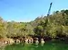 John J. Craig Quarry Historic District |
July 25, 1989 (#89000874) |
Marmor Rd., 0.5 miles south of Miser Station Rd. 35°46′25″N 84°06′33″W |
Friendsville | Early-20th century Tennessee pink marble quarry |
| 17 | Gideon Crawford House | 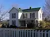 Gideon Crawford House |
July 25, 1989 (#89000875) |
Maryville College campus 35°45′04″N 83°57′41″W |
Maryville | |
| 18 | James R. Davis House | 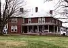 James R. Davis House |
July 25, 1989 (#89000876) |
Junction of River Rd. and Davis Ford Rd. 35°46′19″N 83°51′01″W |
Walland | |
| 19 | Federal Building | 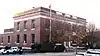 Federal Building |
August 31, 1989 (#89001217) |
201 E. Broadway 35°45′24″N 83°58′15″W |
Maryville | Post office and federal building constructed under the supervision of James A. Wetmore |
| 20 | A.J. Fisher House | 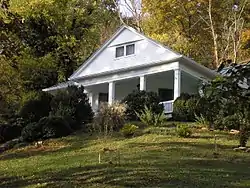 A.J. Fisher House |
July 25, 1989 (#89000877) |
Old Walland Highway 35°43′48″N 83°48′50″W |
Walland | |
| 21 | Samuel Frazier House | 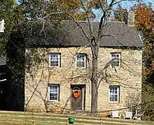 Samuel Frazier House |
July 25, 1989 (#89000878) |
Junction of Marble Hill Rd. and Big Springs Rd. 35°44′24″N 84°06′59″W |
Friendsville | Late-18th century house built of locally-quarried dark marble |
| 22 | Friends Church | 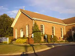 Friends Church |
July 25, 1989 (#89000879) |
314 W. Broadway 35°45′11″N 83°58′25″W |
Maryville | |
| 23 | Samuel George House | 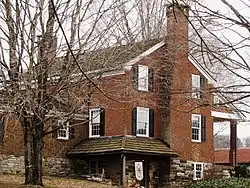 Samuel George House |
January 27, 1982 (#82003952) |
Northeast of Louisville on Topside Rd. 35°50′29″N 84°00′07″W |
Louisville | Brick house built in the early 1800s |
| 24 | James Gillespie House | July 25, 1989 (#89000880) |
Lowes Ferry Rd., 1 mile north of Louisville 35°50′30″N 84°05′14″W |
Louisville | ||
| 25 | John Hackney House | July 25, 1989 (#89000881) |
Front and Main Sts. 35°45′27″N 84°07′54″W |
Friendsville | ||
| 26 | John Hackney Mill Site | July 25, 1989 (#89000882) |
Main St. near Front St. 35°45′22″N 84°07′55″W |
Friendsville | ||
| 27 | Alexander Hamil House |  Alexander Hamil House |
July 25, 1989 (#89000883) |
Morganton Rd., 0.5 miles east of Clover Hill Rd. 35°42′45″N 84°04′03″W |
Maryville | Brick "I" section built in the 1830s; frame front section built c. 1885 |
| 28 | Happy Valley School | 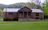 Happy Valley School |
July 25, 1989 (#89000884) |
Happy Valley Rd. 35°36′35″N 83°57′22″W |
Maryville | Located in the Happy Valley community; later converted into a meeting hall |
| 29 | Harper Memorial Library | 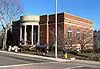 Harper Memorial Library |
July 25, 1989 (#89000885) |
300 E. Church St. 35°45′24″N 83°58′10″W |
Maryville | |
| 30 | William Henderson House | July 25, 1989 (#89000886) |
Louisville Rd., 0.75 miles south of Lowes Ferry Rd. 35°49′26″N 84°05′41″W |
Louisville | ||
| 31 | Henry House | 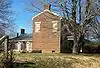 Henry House |
November 1, 1974 (#74001901) |
Southwest of Binfield on Henry Lane Boundary increase (listed July 6, 2011): Henry Farm, 305 Henry Ln., Brick Mill vicinity 35°40′15″N 84°06′25″W |
Binfield | Farmhouse on the farm founded by Samuel Henry, Revolutionary War quartermaster who arrived in Blount County as early as 1792, built a fort called Henry’s Station, and established a farm on his land grant. The substantial farmhouse was built in 1833 by Samuel's son James and his wife, Narcissa Howard, reportedly using brick made by slaves from red clay excavated on the farm property.[6] |
| 32 | John Hitch House | 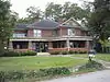 John Hitch House |
April 16, 1993 (#89000924) |
Lee Lambert Rd., 0.5 miles south of Old Walland Highway 35°45′04″N 83°52′55″W |
Maryville | |
| 33 | Pete Hood House | 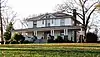 Pete Hood House |
July 25, 1989 (#89000888) |
827 W. Broadway 35°44′55″N 83°58′50″W |
Maryville | Residence of early ALCOA executive Benton Glascock and his descendants |
| 34 | Indiana Avenue Historic District | 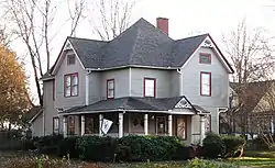 Indiana Avenue Historic District |
August 21, 1989 (#89001071) |
Roughly bounded by Goddard St., Court St., Indiana Ave., and Cates St. 35°45′00″N 83°58′07″W |
Maryville | Now called the College Hill Historic District; includes several dozen houses built circa 1880–1940 |
| 35 | David Jones House | 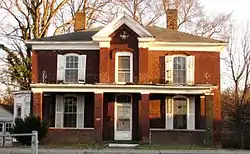 David Jones House |
July 25, 1989 (#89000889) |
404 High St. 35°45′21″N 83°57′56″W |
Maryville | |
| 36 | David Jones House | 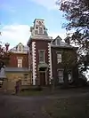 David Jones House |
August 26, 1982 (#82004840) |
720 Tuckaleechee Pike 35°45′19″N 83°57′42″W |
Maryville | |
| 37 | Macklin Kerr House | 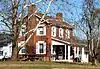 Macklin Kerr House |
July 25, 1989 (#89000891) |
Big Gully Rd., 0.3 miles north of Kyker Rd. 35°36′19″N 84°07′26″W |
Maryville | Built circa 1847; briefly housed Union soldiers during the Civil War |
| 38 | Hezekiah Kizer House | 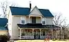 Hezekiah Kizer House |
July 25, 1989 (#89000892) |
0.5 miles south of the junction of Marble Hill Rd. and Dunlap Hollow Rd. 35°42′49″N 84°09′07″W |
Maryville | |
| 39 | Look Rock Observation Tower | 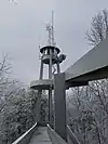 Look Rock Observation Tower |
October 12, 2017 (#100001750) |
Foothills Pkwy. W. 35°37′57″N 83°56′35″W |
Walland vicinity | |
| 40 | Louisville Historic District |  Louisville Historic District |
December 23, 1974 (#74001902) |
Between railroad tracks and the Tennessee River 35°49′23″N 84°03′01″W |
Louisville | Additional documentation, December 2013 |
| 41 | James Martin House | 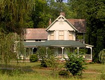 James Martin House |
July 25, 1989 (#89000893) |
Martin Rd., 1 mile east of E. Millers Cove Rd. 35°43′47″N 83°47′46″W |
Walland | |
| 42 | John Martin Mill | 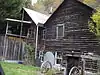 John Martin Mill |
July 25, 1989 (#89000894) |
Mill Rd., 0.3 miles south of W. Millers Cove Rd. 35°42′33″N 83°49′24″W |
Walland | |
| 43 | Warner Martin House | 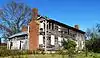 Warner Martin House |
July 25, 1989 (#89000895) |
Central Point Rd. at Old Nails Creek 35°49′19″N 83°52′46″W |
Rockford | Circa-1790s frame house |
| 44 | Maryville College Historic District | 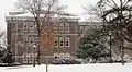 Maryville College Historic District |
September 9, 1982 (#82003953) |
Washington St. 35°45′07″N 83°57′51″W |
Maryville | Includes Willard House (1891), Bartlett Hall (1901), Fayerweather Science Hall (1898), Carnegie Hall (1917), Thaw Hall (1923), and several others |
| 45 | James McCampbell Barn | July 25, 1989 (#89000896) |
Old Cades Cove Rd., 0.1 miles south of Dry Valley Rd. 35°39′55″N 83°47′21″W |
Townsend | ||
| 46 | Minnis McCampbell Barn | July 25, 1989 (#89000897) |
Old Cades Cove Rd., 0.1 miles south of Dry Valley Rd. 35°39′54″N 83°47′14″W |
Townsend | ||
| 47 | John McConnell House | 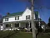 John McConnell House |
July 25, 1989 (#89000898) |
McConnell Rd., 0.5 miles west of Maple Lane Rd. 35°41′27″N 84°08′24″W |
Maryville | |
| 48 | Thomas McCullock House | July 25, 1989 (#89000899) |
Junction of Martin Mill Pike and State Route 33 35°49′21″N 83°56′17″W |
Rockford | ||
| 49 | McNutt-Howard House | 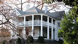 McNutt-Howard House |
July 25, 1989 (#89000900) |
825 W. Broadway Ave. 35°44′59″N 83°58′49″W |
Maryville | |
| 50 | McNutt-McReynolds House | 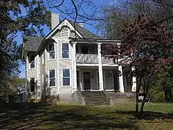 McNutt-McReynolds House |
July 25, 1989 (#89000901) |
803 W. Broadway Ave. 35°45′00″N 83°58′47″W |
Maryville | |
| 51 | Millennium Manor | November 18, 2020 (#100005788) |
500 North Wright Rd. 35°46′48″N 83°57′54″W |
Alcoa | ||
| 52 | Miser Station Store | Miser Station Store |
July 25, 1989 (#89000902) |
Junction of Miser School Rd. and Miser Station Rd. 35°46′41″N 84°05′29″W |
Friendsville | Rural grocery store built c. 1925 |
| 53 | Morningside | 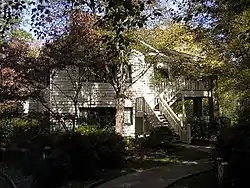 Morningside |
July 25, 1989 (#89000904) |
Maryville College campus 35°44′45″N 83°57′37″W |
Maryville | |
| 54 | Samuel A. Patton Building | 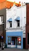 Samuel A. Patton Building |
July 25, 1989 (#89000905) |
114 E. Broadway Ave. 35°45′23″N 83°58′15″W |
Maryville | Late-19th century commercial building that once housed a jewelry store; now a bar known as "The Sandwich Shop" |
| 55 | Peery Mill Site | 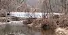 Peery Mill Site |
July 25, 1989 (#89000887) |
Old Walland Highway, 0.1 miles north of Cold Springs Rd. 35°44′58″N 83°50′07″W |
Walland | Mill dam located downstream from the Misty River Campground |
| 56 | People's Bank of Friendsville | 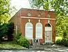 People's Bank of Friendsville |
July 25, 1989 (#89000906) |
College St. 35°45′36″N 84°08′02″W |
Friendsville | Built in 1915; the bank operated until forced to close during the Great Depression |
| 57 | Pistol Creek Dam and Mill Race | 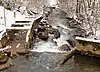 Pistol Creek Dam and Mill Race |
July 25, 1989 (#89000907) |
Pistol Creek between Church Ave. and Ellis St. 35°45′07″N 83°58′01″W |
Maryville | Ruins of the Pistol Creek Mill, located just off the greenway at Greenbelt Park |
| 58 | Stephen Porter House | July 25, 1989 (#89000908) |
Martin Mill Pike, 0.2 miles west of Glover Rd. 35°49′20″N 83°54′15″W |
Rockford | ||
| 59 | John M. Rorex House | 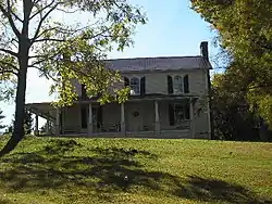 John M. Rorex House |
July 25, 1989 (#89000909) |
Junction of Brick Mill Rd. and Old Niles Ferry Rd. 35°39′30″N 84°06′18″W |
Maryville | |
| 60 | Russell-Lackey-Prater House | November 20, 1989 (#89001961) |
Prater Rd. off Old Lowes Ferry Rd. at Poland Creek 35°50′04″N 84°06′32″W |
Louisville | ||
| 61 | Sam Houston Schoolhouse | 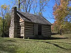 Sam Houston Schoolhouse |
June 13, 1972 (#72001228) |
Northeast of Maryville on State Route 8 35°48′07″N 83°54′16″W |
Maryville | One-room log cabin schoolhouse, built in 1794, where Sam Houston taught as a young man |
| 62 | Shaddon Mill Site | August 21, 1989 (#89001094) |
Ninemile Creek at junction of Big Elm and Trigonia Rds. 35°36′21″N 84°10′21″W |
Maryville | ||
| 63 | John F. Shea House | 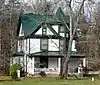 John F. Shea House |
July 25, 1989 (#89000910) |
Old Walland Highway 35°40′37″N 83°45′20″W |
Townsend | Queen Anne-style house built in 1904 by Little River Lumber Company executive John Shea |
| 64 | Southern Railroad Bridge | 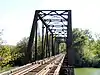 Southern Railroad Bridge |
July 25, 1989 (#89000911) |
Southern Railroad right-of-way over the Little River 35°50′52″N 83°56′45″W |
Rockford | Truss bridge built in 1930 by the Edgemoor Bridge Works |
| 65 | Southern Railroad Freight Depot | 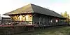 Southern Railroad Freight Depot |
July 25, 1989 (#89000912) |
Southern Railroad right-of-way between Sevierville Rd. and Washington Ave. 35°45′30″N 83°57′53″W |
Maryville | |
| 66 | Dr. William P. Stevenson House | 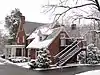 Dr. William P. Stevenson House |
July 25, 1989 (#89000913) |
Maryville College campus 35°44′45″N 83°57′21″W |
Maryville | Now called the "House in the Woods" |
| 67 | Thompson-Brown House | 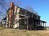 Thompson-Brown House |
November 2, 1978 (#78002574) |
1005 Tuckleechee Pike 35°45′16″N 83°57′22″W |
Maryville | |
| 68 | Carl Trundle Barn | 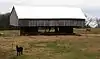 Carl Trundle Barn |
July 25, 1989 (#89000890) |
Junction of U.S. Route 411 and Wildwood Rd. 35°48′01″N 83°51′30″W |
Wildwood | Double-cantilever barn |
| 69 | Tobler Vineyard House | July 25, 1989 (#89000914) |
Hollybrook Rd., 1 mile north of Martin Mill Pike 35°49′59″N 83°54′20″W |
Rockford | ||
| 70 | Vose School | July 24, 2017 (#100001368) |
Birch & Locust Sts. 35°47′45″N 83°58′20″W |
Alcoa | ||
| 71 | Walland Bridge | 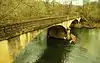 Walland Bridge |
July 25, 1989 (#89000915) |
Old Walland Rd. over the Little River 35°43′46″N 83°48′58″W |
Walland | Located just upstream from the modern vehicle bridge, and accessible from the gas station at junction of 321 and E. Millers Cove Rd. |
| 72 | Walland Power Plant | 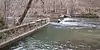 Walland Power Plant |
July 25, 1989 (#89000916) |
Old Walland Highway, 0.75 miles north of Walland 35°44′11″N 83°49′23″W |
Walland | Partial mill dam located just upstream from the Misty River Campground |
| 73 | Marcus Warren House |  Marcus Warren House |
July 25, 1989 (#89000917) |
Miser Station Rd., 0.2 miles south of Middle Settlement Rd. 35°47′44″N 84°03′26″W |
Louisville | Built late-19th century; the Warren Farm is now a Tennessee Century Farm |
| 74 | White's Mill | 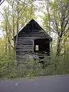 White's Mill |
July 25, 1989 (#89000918) |
Old White's Mill Rd. 35°44′03″N 83°53′02″W |
Maryville | |
| 75 | Willard-Clark House | 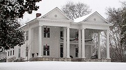 Willard-Clark House |
July 25, 1989 (#89000919) |
1125 Broadway 35°44′42″N 83°59′04″W |
Maryville | Built in the early 1900s, designed by Charles H. Young |
| 76 | Isaac Yearout House | 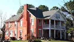 Isaac Yearout House |
July 25, 1989 (#89000920) |
Big Springs Rd., 0.3 miles north of Morganton Rd. 35°44′59″N 84°00′25″W |
Alcoa |
Former listings
Three other sites were previously listed, but have been removed:
| [3] | Name on the Register | Image | Date listed | Date removed | Location | City or town | Summary |
|---|---|---|---|---|---|---|---|
| 1 | Alcoa South Plant Office |  Alcoa South Plant Office |
August 18, 1989 (#89001070) | March 10, 2009 | Hall Road |
Alcoa | |
| 2 | Alcoa West Plant Office | July 25, 1989 (#89000863) | November 15, 2006 | Lodge Street |
Alcoa | ||
| 3 | Little River Lumber Company Office | November 8, 1974 (#74001903) | November 10, 1986 | TN 73 |
Townsend |
See also
| Wikimedia Commons has media related to National Register of Historic Places in Blount County, Tennessee. |
References
- The latitude and longitude information provided in this table was derived originally from the National Register Information System, which has been found to be fairly accurate for about 99% of listings. Some locations in this table may have been corrected to current GPS standards.
- "National Register of Historic Places: Weekly List Actions". National Park Service, United States Department of the Interior. Retrieved on January 29, 2021.
- Numbers represent an alphabetical ordering by significant words. Various colorings, defined here, differentiate National Historic Landmarks and historic districts from other NRHP buildings, structures, sites or objects.
- "National Register Information System". National Register of Historic Places. National Park Service. April 24, 2008.
- The eight-digit number below each date is the number assigned to each location in the National Register Information System database, which can be viewed by clicking the number.
- Blount County Farm Joins State's Century Farms Program, Office of News and Public Affairs, Middle Tennessee State University, press release, September 22, 2009
| Topics | |
|---|---|
| Lists by state |
|
| Lists by insular areas | |
| Lists by associated state | |
| Other areas | |
| Related | |
| |
Municipalities and communities of Blount County, Tennessee, United States | ||
|---|---|---|
| Cities | ||
| Towns | ||
| CDPs | ||
| Unincorporated communities | ||
| Footnotes | ‡This populated place also has portions in an adjacent county or counties | |
| ||
This article is issued from Wikipedia. The text is licensed under Creative Commons - Attribution - Sharealike. Additional terms may apply for the media files.