National Register of Historic Places listings in Madison County, Tennessee
This is a list of the National Register of Historic Places listings in Madison County, Tennessee.
Location of Madison County in Tennessee
This is intended to be a complete list of the properties and districts on the National Register of Historic Places in Madison County, Tennessee, United States. Latitude and longitude coordinates are provided for many National Register properties and districts; these locations may be seen together in a map.[1]
There are 30 properties and districts listed on the National Register in the county, including 1 National Historic Landmark.
| Anderson – Bedford – Benton – Bledsoe – Blount – Bradley – Campbell – Cannon – Carroll – Carter – Cheatham – Chester – Claiborne – Clay – Cocke – Coffee – Crockett – Cumberland – Davidson – Decatur – DeKalb – Dickson – Dyer – Fayette – Fentress – Franklin – Gibson – Giles – Grainger – Greene – Grundy – Hamblen – Hamilton – Hancock – Hardeman – Hardin – Hawkins – Haywood – Henderson – Henry – Hickman – Houston – Humphreys – Jackson – Jefferson – Johnson – Knox – Lake – Lauderdale – Lawrence – Lewis – Lincoln – Loudon – Macon – Madison – Marion – Marshall – Maury – McMinn – McNairy – Meigs – Monroe – Montgomery – Moore – Morgan – Obion – Overton – Perry – Pickett – Polk – Putnam – Rhea – Roane – Robertson – Rutherford – Scott – Sequatchie – Sevier – Shelby – Smith – Stewart – Sullivan – Sumner – Tipton – Trousdale – Unicoi – Union – Van Buren – Warren – Washington – Wayne – Weakley – White – Williamson – Wilson |
- This National Park Service list is complete through NPS recent listings posted January 29, 2021.[2]
Current listings
| [3] | Name on the Register[4] | Image | Date listed[5] | Location | City or town | Description |
|---|---|---|---|---|---|---|
| 1 | Anderson Presbyterian Church | March 15, 2007 (#07000157) |
899 Steam Mill Ferry Rd. 35°33′42″N 88°52′22″W |
Madison Hall | ||
| 2 | Bemis Historic District | December 16, 1991 (#91001777) |
Roughly bounded by D St., the Illinois Central railroad tracks, 6th St., and rural property lines to the west and south 35°34′23″N 88°49′31″W |
Jackson | Includes the Bemis mill.[6] | |
| 3 | The Cedars | 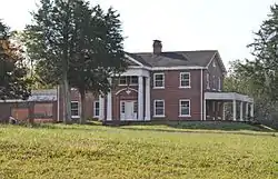 The Cedars |
May 5, 1999 (#99000536) |
260 Cotton Grove Rd. 35°37′57″N 88°45′03″W |
Jackson | |
| 4 | Chevy Chase House and First Presbyterian Church Complex | November 20, 2015 (#15000834) |
1573 N. Highland Ave. 35°38′29″N 88°49′42″W |
Jackson | ||
| 5 | Deberry-Hurt House | July 8, 1980 (#80003846) |
Southwest of Jackson 35°36′43″N 88°44′48″W |
Jackson | ||
| 6 | Denmark Mound Group | December 7, 1992 (#92001656) |
Address Restricted |
Denmark | ||
| 7 | Denmark Presbyterian Church | 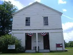 Denmark Presbyterian Church |
June 16, 1983 (#83003048) |
Jackson-Denmark Rd. 35°31′56″N 89°00′01″W |
Denmark | |
| 8 | East Main Street Historic District |  East Main Street Historic District |
July 3, 1980 (#80003847) |
Irregular pattern along E. Main St. 35°36′50″N 88°48′35″W |
Jackson | |
| 9 | Capt. H. P. Farrar House |  Capt. H. P. Farrar House |
April 15, 1982 (#82003989) |
161 West Orleans St. 35°37′08″N 88°49′19″W |
Jackson | |
| 10 | Greyhound Bus Station | 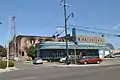 Greyhound Bus Station |
February 11, 1993 (#92001871) |
407 E. Main St. 35°36′52″N 88°48′58″W |
Jackson | |
| 11 | William Holland, Jr., House | 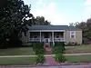 William Holland, Jr., House |
July 11, 2005 (#05000696) |
215 Roland Ave. 35°38′05″N 88°49′14″W |
Jackson | |
| 12 | Hollywood Cemetery | 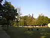 Hollywood Cemetery |
May 22, 2003 (#03000430) |
406 Hollywood Dr. 35°37′26″N 88°50′01″W |
Jackson | |
| 13 | Illinois Central Railroad Division Office |  Illinois Central Railroad Division Office |
February 11, 1993 (#92001869) |
245 W. Sycamore St. 35°36′43″N 88°49′21″W |
Jackson | |
| 14 | Jackson Free Library | 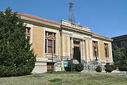 Jackson Free Library |
June 26, 1975 (#75001769) |
College and Church Sts. 35°36′58″N 88°49′01″W |
Jackson | |
| 15 | Lane College Historic District |  Lane College Historic District |
July 2, 1987 (#87001117) |
Lane Ave.; also an area including the president's house and Lane Ave. to the original district boundary 35°37′41″N 88°48′26″W |
Jackson | Second set of boundaries represents a boundary increase of November 8, 1991 |
| 16 | Madison County Courthouse | 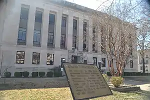 Madison County Courthouse |
March 30, 1995 (#95000342) |
Public Sq. 35°36′49″N 88°49′10″W |
Jackson | |
| 17 | Mt. Olivet Cemetery | March 20, 2002 (#02000237) |
E. Forest Ave. 35°38′10″N 88°48′29″W |
Jackson | ||
| 18 | Murphy Hotel |  Murphy Hotel |
February 11, 1993 (#92001872) |
545 S. Royal St. 35°36′22″N 88°48′51″W |
Jackson | |
| 19 | Nashville, Chattanooga & St. Louis Passenger Depot-Jackson | 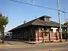 Nashville, Chattanooga & St. Louis Passenger Depot-Jackson |
February 11, 1993 (#92001870) |
590 S. Royal St. 35°36′20″N 88°48′47″W |
Jackson | |
| 20 | New Southern Hotel |  New Southern Hotel |
November 21, 2002 (#02001378) |
112-120 E. Baltimore St. 35°36′48″N 88°49′07″W |
Jackson | |
| 21 | Northwood Avenue Historic District | November 7, 1990 (#90001659) |
1-38 Northwood Ave. 35°37′52″N 88°48′55″W |
Jackson | ||
| 22 | Oakslea Place |  Oakslea Place |
December 18, 2003 (#03001305) |
1210 N. Highland Ave. 35°37′58″N 88°49′05″W |
Jackson | |
| 23 | Pinson Mounds |  Pinson Mounds |
October 15, 1966 (#66000727) |
460 Ozier Rd.[7] 35°30′00″N 88°41′48″W |
Pinson | |
| 24 | Riverside Cemetery | May 9, 2003 (#03000394) |
300 Riverside Dr. 35°36′38″N 88°49′31″W |
Jackson | ||
| 25 | Ross-Sewell House | 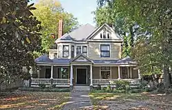 Ross-Sewell House |
January 27, 1983 (#83003049) |
909 Highland Ave. 35°37′42″N 88°49′08″W |
Jackson | |
| 26 | St. Luke Episcopal Church |  St. Luke Episcopal Church |
May 24, 1984 (#84003600) |
309 E. Baltimore St. 35°36′49″N 88°49′01″W |
Jackson | |
| 27 | Southern Engine and Boiler Works | Southern Engine and Boiler Works |
February 11, 1993 (#92001868) |
342 N. Royal St. 35°37′05″N 88°48′46″W |
Jackson | |
| 28 | Temple B'Nai Israel | 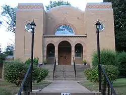 Temple B'Nai Israel |
July 16, 2008 (#08000687) |
401 W. Grand St. 35°37′39″N 88°49′28″W |
Jackson | |
| 29 | U.S. Post Office and Court House | February 28, 2017 (#100000692) |
109 S. Highland Ave. 35°36′50″N 88°49′11″W |
Jackson | Now called the Ed Jones Federal Building and United States Courthouse. | |
| 30 | William Kirby Walsh House | 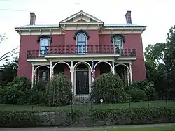 William Kirby Walsh House |
December 10, 1993 (#93001374) |
204 E. Deaderick St. 35°37′11″N 88°48′55″W |
Jackson |
Former listings
| [3] | Name on the Register | Image | Date listed | Date removed | Location | City or town | Summary |
|---|---|---|---|---|---|---|---|
| 1 | Casey Jones Home and Railroad Museum | September 7, 1972 (#72001244) | 1980 | 211 W. Chester St. |
Jackson |
See also
| Wikimedia Commons has media related to National Register of Historic Places in Madison County, Tennessee. |
References
- The latitude and longitude information provided in this table was derived originally from the National Register Information System, which has been found to be fairly accurate for about 99% of listings. Some locations in this table may have been corrected to current GPS standards.
- "National Register of Historic Places: Weekly List Actions". National Park Service, United States Department of the Interior. Retrieved on January 29, 2021.
- Numbers represent an alphabetical ordering by significant words. Various colorings, defined here, differentiate National Historic Landmarks and historic districts from other NRHP buildings, structures, sites or objects.
- "National Register Information System". National Register of Historic Places. National Park Service. April 24, 2008.
- The eight-digit number below each date is the number assigned to each location in the National Register Information System database, which can be viewed by clicking the number.
- Tennessee Historical Commission, The Courier Archived 2011-07-12 at the Wayback Machine, Vol . XLIX, No. 2, June 2011, page 15
- Location derived from this Tennessee Department of Environment and Conservation website; the NRIS lists the site as "Address Restricted"
| Topics | |
|---|---|
| Lists by state |
|
| Lists by insular areas | |
| Lists by associated state | |
| Other areas | |
| Related | |
| |
Municipalities and communities of Madison County, Tennessee, United States | ||
|---|---|---|
| Cities | Madison County map | |
| Unincorporated communities | ||
| Footnotes | ‡This populated place also has portions in an adjacent county or counties | |
| ||
This article is issued from Wikipedia. The text is licensed under Creative Commons - Attribution - Sharealike. Additional terms may apply for the media files.