National Register of Historic Places listings in Washington County, Tennessee
This is a list of the National Register of Historic Places listings in Washington County, Tennessee.
This is intended to be a complete list of the properties and districts on the National Register of Historic Places in Washington County, Tennessee, United States. Latitude and longitude coordinates are provided for many National Register properties and districts; these locations may be seen together in a map.[1]
There are 37 properties and districts listed on the National Register in the county. One site has been further designated a National Historic Landmark. Three other sites were once listed, but have since been removed.
See also National Register of Historic Places listings in Carter County, Tennessee for additional properties in Johnson City, a city that spans the county line.
| Anderson – Bedford – Benton – Bledsoe – Blount – Bradley – Campbell – Cannon – Carroll – Carter – Cheatham – Chester – Claiborne – Clay – Cocke – Coffee – Crockett – Cumberland – Davidson – Decatur – DeKalb – Dickson – Dyer – Fayette – Fentress – Franklin – Gibson – Giles – Grainger – Greene – Grundy – Hamblen – Hamilton – Hancock – Hardeman – Hardin – Hawkins – Haywood – Henderson – Henry – Hickman – Houston – Humphreys – Jackson – Jefferson – Johnson – Knox – Lake – Lauderdale – Lawrence – Lewis – Lincoln – Loudon – Macon – Madison – Marion – Marshall – Maury – McMinn – McNairy – Meigs – Monroe – Montgomery – Moore – Morgan – Obion – Overton – Perry – Pickett – Polk – Putnam – Rhea – Roane – Robertson – Rutherford – Scott – Sequatchie – Sevier – Shelby – Smith – Stewart – Sullivan – Sumner – Tipton – Trousdale – Unicoi – Union – Van Buren – Warren – Washington – Wayne – Weakley – White – Williamson – Wilson |
- This National Park Service list is complete through NPS recent listings posted January 29, 2021.[2]
Current listings
| [3] | Name on the Register[4] | Image | Date listed[5] | Location | City or town | Description |
|---|---|---|---|---|---|---|
| 1 | Aquone | 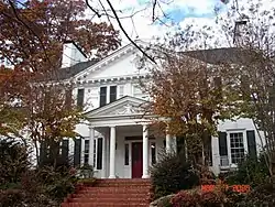 Aquone |
November 4, 1993 (#93001199) |
110 Barberry Rd. 36°19′37″N 82°22′03″W |
Johnson City | |
| 2 | Bashor Mill | July 8, 1980 (#80003878) |
Northeast of Johnson City 36°20′51″N 82°24′17″W |
Johnson City | ||
| 3 | Boone Hydroelectric Project |  Boone Hydroelectric Project |
October 26, 2017 (#100001476) |
301 Boone Dam Rd. 36°26′25″N 82°26′19″W |
Kingsport | Extends into Sullivan County |
| 4 | Brown Farm | December 29, 2014 (#14001107) |
359 Taylor Bridge Rd. 36°12′22″N 82°29′13″W |
Jonesborough | ||
| 5 | Adam Alexander Broyles House | March 21, 2011 (#11000099) |
3118 Old State Route 34 36°13′19″N 82°35′54″W |
Limestone | ||
| 6 | Broylesville Historic District | 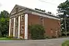 Broylesville Historic District |
March 28, 1985 (#85000677) |
Roughly bounded by Old State Route 34, Taylor Mill and Gravel Hill Rds. along Little Limestone Creek 36°12′44″N 82°36′16″W |
Washington College | Late-18th and early-19th century community initially developed by Adam Broyles, Jr., and his children. Inventory form. |
| 7 | Carolina, Clinchfield & Ohio Railroad Station and Depot | 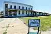 Carolina, Clinchfield & Ohio Railroad Station and Depot |
March 27, 2008 (#08000238) |
300 Buffalo St. 36°18′51″N 82°21′10″W |
Johnson City | |
| 8 | Isaac Cooper House | September 7, 1984 (#84003723) |
Glendale Rd. 36°19′21″N 82°37′06″W |
Limestone | ||
| 9 | DeVault Tavern | 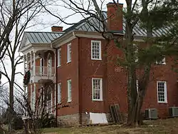 DeVault Tavern |
June 4, 1973 (#73001855) |
West of Jonesborough on Leesburg Rd. 36°17′33″N 82°32′32″W |
Jonesborough | |
| 10 | Valentine DeVault House | July 29, 1977 (#77001298) |
5 miles north of Johnson City off DeVault Lane 36°23′20″N 82°21′12″W |
Johnson City | ||
| 11 | Dungan's Mill and Stone House | July 2, 1973 (#73001854) |
Northeast of Johnson City on Watauga Rd. 36°22′08″N 82°18′15″W |
Johnson City | ||
| 12 | Embree House | February 14, 1978 (#78002647) |
Southwest of Telford on Walker's Mill Rd. 36°14′44″N 82°33′16″W |
Telford | ||
| 13 | Col. George Gillespie House | August 22, 1977 (#77001299) |
Old State Route 34 near Davy Crockett Park Rd. 36°13′23″N 82°37′58″W |
Limestone | ||
| 14 | Isaac Hammer House | March 19, 1976 (#76001805) |
North of Johnson City off U.S. Route 11 36°22′10″N 82°22′56″W |
Johnson City | ||
| 15 | Henry Hoss House | 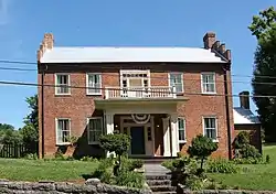 Henry Hoss House |
December 16, 1982 (#82001734) |
Blountville Rd. 36°18′20″N 82°27′49″W |
Jonesborough | |
| 16 | Johnson City Commercial Historic District | 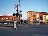 Johnson City Commercial Historic District |
July 17, 2003 (#03000666) |
E. Market St., E. Main St., Tipton St., Buffalo St., Spring St., S. Roan St., and Colonial Way 36°19′01″N 82°21′04″W |
Johnson City | |
| 17 | Johnson City Country Club | November 15, 2011 (#11000809) |
1901 E. Unaka Ave. 36°20′36″N 82°20′27″W |
Johnson City | ||
| 18 | Johnson City Postal Savings Bank and Post Office | November 17, 2020 (#100005792) |
401 Ashe St. 36°18′47″N 82°21′12″W |
Johnson City | ||
| 19 | Johnson City Warehouse and Commerce Historic District |  Johnson City Warehouse and Commerce Historic District |
July 17, 2003 (#03000667) |
Commerce St., W. Market St., McClure St., and Boone St.; also 107 N. Boone, 100-102, 104, 200, 204, 210, and 214 Montgomery Sts. 36°19′02″N 82°21′15″W |
Johnson City | Second set of addresses represents a boundary decrease of December 2, 2014 |
| 20 | Jonesborough Historic District | 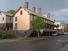 Jonesborough Historic District |
December 23, 1969 (#69000183) |
Roughly bounded by Depot and College Sts., 3rd Ave., and the junction of Main St. and Franklin Ave.; also
roughly along E. Main St. from Franklin Ave. and 624 E. Main St.; also roughly along S. Cherokee St. from Depot St. to 504 S. Cherokee St., and Locust St. |
Jonesborough | Second set of addresses represent a boundary increase of November 27, 2019 |
| 21 | Martin Kitzmiller House | July 25, 1985 (#85001609) |
U.S. Route 23, Boone's Creek 36°23′47″N 82°24′53″W |
Gray | ||
| 22 | Knob Creek Historic District | July 10, 1986 (#86001543) |
Gray Station, Knob Creek, and Fair Ridge Rds. 36°20′30″N 82°24′35″W |
Johnson City | ||
| 23 | Montrose Court Apartments | 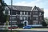 Montrose Court Apartments |
April 21, 1980 (#80003879) |
Montrose Ct. 36°18′24″N 82°21′26″W |
Johnson City | |
| 24 | Mountain Branch, National Home for Disabled Volunteer Soldiers | 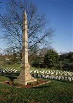 Mountain Branch, National Home for Disabled Volunteer Soldiers |
June 17, 2011 (#11000560) |
Corner of Lamont and Sidney Sts. 36°18′38″N 82°22′24″W |
Johnson City | |
| 25 | Plum Grove Archaeological Site | September 5, 1985 (#85002353) |
Address Restricted |
Jonesborough | ||
| 26 | Peter Range Stone House |  Peter Range Stone House |
December 15, 1983 (#83004312) |
307 Twin Falls Dr. 36°21′31″N 82°22′42″W |
Johnson City | |
| 27 | Robin's Roost |  Robin's Roost |
January 20, 1976 (#76001806) |
S. Roane St. 36°18′38″N 82°20′41″W |
Johnson City | |
| 28 | St. Paul AME Zion Church | 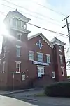 St. Paul AME Zion Church |
April 12, 2001 (#01000382) |
201 Welbourne St. 36°19′15″N 82°21′08″W |
Johnson City | |
| 29 | Salem Presbyterian Church | 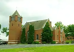 Salem Presbyterian Church |
September 22, 1992 (#92001255) |
147 Washington College Rd. 36°13′08″N 82°34′20″W |
Limestone | Listed both individually and as a contributing property in the Washington College Historic District; designed by architect A. Page Brown. |
| 30 | Shelbridge | December 14, 1995 (#95001477) |
Junction of N. Roan and E. 11th Sts. 36°19′38″N 82°21′52″W |
Johnson City | ||
| 31 | Sulphur Springs Methodist Campground | 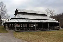 Sulphur Springs Methodist Campground |
May 12, 1975 (#75001796) |
North of Jonesborough off State Route 81 in Sulphur Springs Community 36°20′53″N 82°32′29″W |
Jonesborough | |
| 32 | Thomas Telford House | 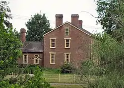 Thomas Telford House |
February 10, 1982 (#82004064) |
Old Jonesborough Water Plant Rd. 36°12′30″N 82°36′17″W |
Limestone | Constructed c. 1815 by Thomas Telford (1766–1816); also a contributing property in the Broylesville Historic District. |
| 33 | Thankful Baptist Church | 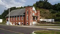 Thankful Baptist Church |
August 8, 2001 (#01000852) |
104 Water St. 36°19′10″N 82°21′04″W |
Johnson City | |
| 34 | Tipton-Haynes House | .jpg.webp) Tipton-Haynes House |
February 26, 1970 (#70000620) |
Southeast of Johnson City on U.S. Route 19W 36°17′37″N 82°20′06″W |
Johnson City | |
| 35 | Tree Streets Historic District |  Tree Streets Historic District |
March 12, 1996 (#96000232) |
Roughly bounded by S. Roan, W. Chestnut, Franklin, and Virginia Sts. and University Parkway 36°18′29″N 82°21′18″W |
Johnson City | |
| 36 | Washington College Historic District |  Washington College Historic District |
July 17, 2002 (#02000812) |
116 Doak Ln. 36°13′04″N 82°34′19″W |
Washington College | Early college established in 1780; most extant buildings constructed in the mid-19th and early-20th centuries. Inventory form. |
| 37 | Wassom Farm | May 2, 2018 (#100002265) |
276 Matthews Mill Rd. 36°14′49″N 82°33′52″W |
Telford |
Former listings
| [3] | Name on the Register | Image | Date listed | Date removed | Location | City or town | Summary |
|---|---|---|---|---|---|---|---|
| 1 | Bowers–Kirkpatrick Farmstead | March 12, 1998 (#97001108) | March 20, 2017 | 3033 Boone's Creek Rd. 36°23′08″N 82°25′00″W |
Gray | ||
| 2 | Memorial Stadium | July 19, 2010 (#10000472) | April 20, 2011 | Intersection of E Main Street and Lonnie Lowe Lane 36°19′17″N 82°20′26″W |
Johnson City | ||
| 3 | Christopher Taylor House | 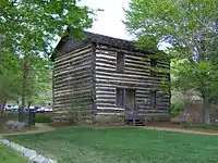 Christopher Taylor House |
December 9, 1971 (#71000839) | April 30, 2009 | Main St. 36°16′35″N 82°29′47″W |
Jonesborough |
See also
| Wikimedia Commons has media related to National Register of Historic Places in Washington County, Tennessee. |
References
- The latitude and longitude information provided in this table was derived originally from the National Register Information System, which has been found to be fairly accurate for about 99% of listings. Some locations in this table may have been corrected to current GPS standards.
- "National Register of Historic Places: Weekly List Actions". National Park Service, United States Department of the Interior. Retrieved on January 29, 2021.
- Numbers represent an alphabetical ordering by significant words. Various colorings, defined here, differentiate National Historic Landmarks and historic districts from other NRHP buildings, structures, sites or objects.
- "National Register Information System". National Register of Historic Places. National Park Service. April 24, 2008.
- The eight-digit number below each date is the number assigned to each location in the National Register Information System database, which can be viewed by clicking the number.
| Topics | |
|---|---|
| Lists by state |
|
| Lists by insular areas | |
| Lists by associated state | |
| Other areas | |
| Related | |
| |
Municipalities and communities of Washington County, Tennessee, United States | ||
|---|---|---|
| Cities | Washington County map | |
| Town | ||
| CDPs | ||
| Unincorporated communities | ||
| Footnotes | ‡This populated place also has portions in an adjacent county or counties | |
| ||