National Register of Historic Places listings in Rutherford County, Tennessee
This is a list of the National Register of Historic Places listings in Rutherford County, Tennessee.
Location of Rutherford County in Tennessee
This is intended to be a complete list of the properties and districts on the National Register of Historic Places in Rutherford County, Tennessee, United States. Latitude and longitude coordinates are provided for many National Register properties and districts; these locations may be seen together in a map.[1]
There are 47 properties and districts listed on the National Register in the county, and five former listings.
| Anderson – Bedford – Benton – Bledsoe – Blount – Bradley – Campbell – Cannon – Carroll – Carter – Cheatham – Chester – Claiborne – Clay – Cocke – Coffee – Crockett – Cumberland – Davidson – Decatur – DeKalb – Dickson – Dyer – Fayette – Fentress – Franklin – Gibson – Giles – Grainger – Greene – Grundy – Hamblen – Hamilton – Hancock – Hardeman – Hardin – Hawkins – Haywood – Henderson – Henry – Hickman – Houston – Humphreys – Jackson – Jefferson – Johnson – Knox – Lake – Lauderdale – Lawrence – Lewis – Lincoln – Loudon – Macon – Madison – Marion – Marshall – Maury – McMinn – McNairy – Meigs – Monroe – Montgomery – Moore – Morgan – Obion – Overton – Perry – Pickett – Polk – Putnam – Rhea – Roane – Robertson – Rutherford – Scott – Sequatchie – Sevier – Shelby – Smith – Stewart – Sullivan – Sumner – Tipton – Trousdale – Unicoi – Union – Van Buren – Warren – Washington – Wayne – Weakley – White – Williamson – Wilson |
- This National Park Service list is complete through NPS recent listings posted January 29, 2021.[2]
Current listings
| [3] | Name on the Register[4] | Image | Date listed[5] | Location | City or town | Description |
|---|---|---|---|---|---|---|
| 1 | Allen Chapel A.M.E. Church | 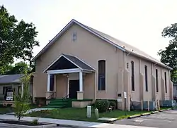 Allen Chapel A.M.E. Church |
March 31, 1995 (#95000291) |
224 S. Maney Ave. 35°50′38″N 86°23′14″W |
Murfreesboro | |
| 2 | Arnold-Harrell House | 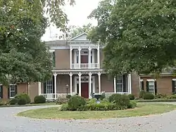 Arnold-Harrell House |
March 27, 1992 (#92000145) |
1710 E. Main St. 35°50′26″N 86°21′51″W |
Murfreesboro | |
| 3 | Beesley Primitive Baptist Church | 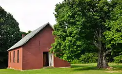 Beesley Primitive Baptist Church |
April 8, 1999 (#99000397) |
461 Beesley Rd. 35°51′11″N 86°29′51″W |
Murfreesboro | |
| 4 | Thomas C. Black House | July 5, 1996 (#96000231) |
4431 Lebanon Rd. 35°55′38″N 86°22′58″W |
Murfreesboro | ||
| 5 | Boxwood | 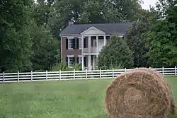 Boxwood |
October 25, 1984 (#84000139) |
Old Salem Pike 35°48′37″N 86°27′09″W |
Murfreesboro | |
| 6 | Bradley Academy | 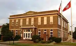 Bradley Academy |
June 14, 1990 (#90000914) |
415 S. Academy St. 35°50′31″N 86°23′19″W |
Murfreesboro | School established 1811; current building completed in 1917 |
| 7 | Caff-E-Hill Farm | April 14, 1995 (#95000412) |
3783 Cripple Creek Rd. 35°46′42″N 86°11′53″W |
Readyville | ||
| 8 | Childress-Ray House |  Childress-Ray House |
December 27, 1979 (#79002458) |
225 N. Academy St. 35°50′51″N 86°23′19″W |
Murfreesboro | Originally built 1847; remodeled 1874 |
| 9 | Collier-Crichlow House | 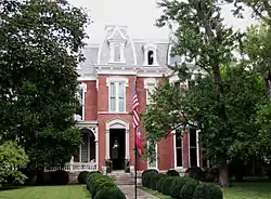 Collier-Crichlow House |
July 16, 1973 (#73001822) |
511 E. Main St. 35°50′42″N 86°22′18″W |
Murfreesboro | Second Empire-style house built in 1879 |
| 10 | Collier-Lane-Crichlow House | 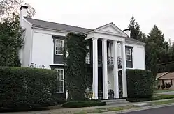 Collier-Lane-Crichlow House |
August 23, 1978 (#78002629) |
500 N. Spring St. 35°51′00″N 86°23′21″W |
Murfreesboro | Commonly called the "House of Mayors"; built in 1850 |
| 11 | Sam Davis House | 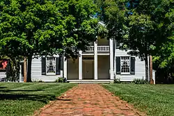 Sam Davis House |
December 23, 1969 (#69000181) |
Northeast of Smyrna off State Route 102 35°59′21″N 86°29′56″W |
Smyrna | |
| 12 | Dement House | June 26, 1986 (#86001379) |
Cainsville Pike 35°55′56″N 86°16′01″W |
Lascassas | ||
| 13 | East Main Street Historic District | 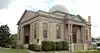 East Main Street Historic District |
July 11, 1985 (#85001516) |
Roughly E. Main, E. Lytle, College, University, and E. Vine Sts. 35°50′42″N 86°22′50″W |
Murfreesboro | |
| 14 | Elmwood | October 15, 1973 (#73001823) |
Northwest of Murfreesboro off U.S. Routes 41/70S; also 5722 Old Nashville Highway 35°53′46″N 86°27′28″W |
Murfreesboro | 5722 Old Nashville Highway represents a boundary increase of July 3, 2007 | |
| 15 | First Presbyterian Church |  First Presbyterian Church |
June 24, 1993 (#93000561) |
210 N. Spring St. 35°50′49″N 86°23′23″W |
Murfreesboro | |
| 16 | Fortress Rosecrans Site |  Fortress Rosecrans Site |
June 7, 1974 (#74001926) |
Old Fort Parkway west of downtown Murfreesboro at the Stones River 35°51′12″N 86°24′41″W |
Murfreesboro | |
| 17 | Logan Henderson Farm | 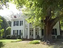 Logan Henderson Farm |
September 25, 2003 (#03000971) |
3600 Manchester Pike 35°47′27″N 86°21′25″W |
Murfreesboro | |
| 18 | Idler's Retreat | 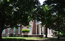 Idler's Retreat |
May 19, 2004 (#04000475) |
112 Oak St. 35°59′15″N 86°30′55″W |
Smyrna | |
| 19 | Jarman Farm | 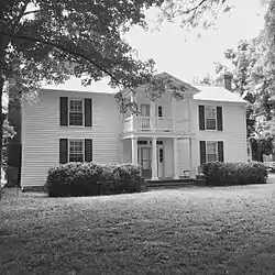 Jarman Farm |
July 6, 1987 (#87001368) |
Cainsville Pike 35°57′46″N 86°15′30″W |
Lascassas | |
| 20 | Enoch H. Jones House | August 25, 1995 (#95001043) |
6339 Halls Hill Pike 35°51′39″N 86°13′04″W |
Murfreesboro | ||
| 21 | William B. Jordan Farm | July 13, 1992 (#92000825) |
2665 Taylor Ln. 35°46′03″N 86°36′10″W |
Eagleville | ||
| 22 | Landsberger-Gerhardt House | December 13, 1993 (#93001397) |
435 N. Spring St. 35°51′00″N 86°23′21″W |
Murfreesboro | ||
| 23 | Uncle Dave Macon House | 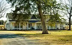 Uncle Dave Macon House |
November 15, 1973 (#73001827) |
West of Readyville on U.S. Route 70S 35°49′27″N 86°14′27″W |
Readyville | Home of banjoist and showman Uncle Dave Macon |
| 24 | Marymont | 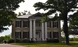 Marymont |
October 30, 1973 (#73001824) |
Southwest of Murfreesboro, off State Route 99 on Rucker Lane 35°49′12″N 86°28′45″W |
Murfreesboro | |
| 25 | William Harrison McCord House | December 20, 1984 (#84001121) |
U.S. Route 41A 35°44′46″N 86°39′06″W |
Eagleville | ||
| 26 | McGill – Becton – Cates Family Farm | November 9, 2005 (#05001220) |
2432 Cripple Creek Rd. 35°47′03″N 86°12′41″W |
Readyville | ||
| 27 | Middle Tennessee State Teachers College Training School |  Middle Tennessee State Teachers College Training School |
January 4, 1993 (#92001731) |
923 E. Lytle St. 35°50′49″N 86°22′31″W |
Murfreesboro | |
| 28 | Morgan House | 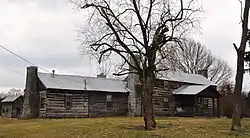 Morgan House |
December 27, 1979 (#79002457) |
Southwest of Christiana 35°39′22″N 86°27′27″W |
Christiana | |
| 29 | Murfreesboro Veterans Administration Hospital Historic District | March 12, 2012 (#12000119) |
3400 Lebanon Pike 35°55′00″N 86°22′41″W |
Murfreesboro | United States Second Generation Veterans Hospitals Multiple Property Submission | |
| 30 | Murray Farm | July 31, 1991 (#91000980) |
9409 Bradyville Rd. 35°45′21″N 86°15′49″W |
Readyville | ||
| 31 | North Maney Avenue Historic District | April 4, 1985 (#85000709) |
Roughly bounded by N. Maney and N. Highland Aves., E. College St., and N. Academy Ave. 35°50′55″N 86°23′10″W |
Murfreesboro | ||
| 32 | Oaklands | .jpg.webp) Oaklands |
February 26, 1970 (#70000616) |
N. Maney Ave. 35°51′21″N 86°23′06″W |
Murfreesboro | |
| 33 | Old First Presbyterian Church and Old City Cemetery | 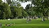 Old First Presbyterian Church and Old City Cemetery |
March 12, 2012 (#12000120) |
390 E. Vine St. 35°50′37″N 86°23′16″W |
Murfreesboro | Cemetery dating to the 1820s and site of the original First Presbyterian Church in Murfreesboro which was destroyed by Union Army troops during the American Civil War[6] |
| 34 | Gen. Joseph B. Palmer House | 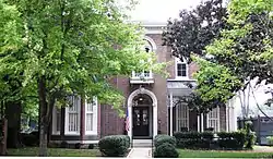 Gen. Joseph B. Palmer House |
September 20, 1973 (#73001825) |
434 E. Main St. 35°50′43″N 86°23′07″W |
Murfreesboro | Built in 1869 by Confederate general Joseph B. Palmer (1825–1890) |
| 35 | Providence Primitive Baptist Church | November 8, 2000 (#00001357) |
256 Central Valley Rd. 35°56′19″N 86°22′51″W |
Walterhill | ||
| 36 | Charles Ready House | 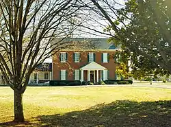 Charles Ready House |
July 2, 1973 (#73001828) |
On U.S. Route 70S 35°49′45″N 86°10′47″W |
Readyville | Known as "The Corners," built in 1829 by Charles Ready |
| 37 | Riverside Farm | December 12, 2006 (#06001132) |
1218 W. Jefferson Pike 35°57′55″N 86°23′21″W |
Walterhill | ||
| 38 | Rockvale Store | September 14, 1995 (#95001114) |
8964 Rockvale Rd. 35°45′27″N 86°31′53″W |
Rockvale | ||
| 39 | Benjamine Rucker House | February 28, 1991 (#91000223) |
3978 Betty Ford Rd. 35°55′14″N 86°19′51″W |
Compton | ||
| 40 | Rutherford County Courthouse | 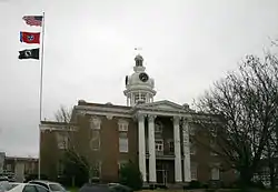 Rutherford County Courthouse |
July 16, 1973 (#73001826) |
Public Square 35°50′46″N 86°23′31″W |
Murfreesboro | |
| 41 | Rutherford Health Department | 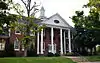 Rutherford Health Department |
July 24, 1992 (#92000960) |
303 N. Church St. 35°50′54″N 86°23′27″W |
Murfreesboro | |
| 42 | Absalom Scales House | October 30, 1973 (#73001821) |
North of Eagleville off State Route 16, on Rocky Glade Rd. 35°46′27″N 86°38′22″W |
Eagleville | ||
| 43 | Searcy – Matthews – Tarpley Farm | July 14, 2011 (#11000459) |
455 W. Jefferson Pike 35°57′08″N 86°23′07″W |
Walterhill | Historic Family Farms in Middle Tennessee MPS | |
| 44 | Robert Andrew Smith Farm | January 4, 1993 (#92001712) |
2568 Armstrong Valley Rd. 35°46′06″N 86°28′45″W |
Murfreesboro | ||
| 45 | John C. Spence House | 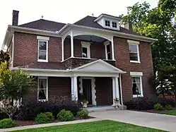 John C. Spence House |
August 23, 2004 (#04000302) |
503 N. Maple St. 35°51′10″N 86°23′32″W |
Murfreesboro | |
| 46 | Stones River National Battlefield | 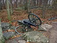 Stones River National Battlefield |
October 15, 1966 (#66000075) |
3 miles (4.8 km) northwest of Murfreesboro on U.S. Route 41 35°52′24″N 86°25′17″W |
Murfreesboro | |
| 47 | Walter Hill Hydroelectric Station | 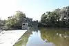 Walter Hill Hydroelectric Station |
November 7, 1990 (#90001660) |
U.S. Route 231 at the Stones River 35°56′37″N 86°22′37″W |
Murfreesboro |
Former listings
Four other properties have previously been listed, but were removed:
| [3] | Name on the Register | Image | Date listed | Date removed | Location | City or town | Summary |
|---|---|---|---|---|---|---|---|
| 1 | Brown's Mill | December 29, 1978 (#78002628) | July 30, 2002 | SE of Lascassas on Brown's Mill Road |
Lascassas | ||
| 2 | Crichlow Grammar School and E. C. Cox Memorial Gym | December 17, 1992 (#92001685) | July 30, 2002 | 400 N. Maple St. and 105 Olive St. |
Murfreesboro | ||
| 3 | Hiram Jenkins House | June 16, 1989 (#89000504) | November 8, 2006 | 1556 Gresham Lane |
Murfreesboro | ||
| 4 | Ridley's Landing | July 16, 1973 (#73001829) | July 24, 2008 | N of Smyrna on Jones Mill Rd., at Stones River |
Smyrna vicinity | ||
| 5 | Thomas Williamson House | June 21, 1996 (#96000687) | November 19, 2014 | 2263 Little Rock Rd. 35°44′58″N 86°37′17″W |
Eagleville |
See also
| Wikimedia Commons has media related to National Register of Historic Places in Rutherford County, Tennessee. |
References
- The latitude and longitude information provided in this table was derived originally from the National Register Information System, which has been found to be fairly accurate for about 99% of listings. Some locations in this table may have been corrected to current GPS standards.
- "National Register of Historic Places: Weekly List Actions". National Park Service, United States Department of the Interior. Retrieved on January 29, 2021.
- Numbers represent an alphabetical ordering by significant words. Various colorings, defined here, differentiate National Historic Landmarks and historic districts from other NRHP buildings, structures, sites or objects.
- "National Register Information System". National Register of Historic Places. National Park Service. April 24, 2008.
- The eight-digit number below each date is the number assigned to each location in the National Register Information System database, which can be viewed by clicking the number.
- West, Mike. "Union army destroyed historic church". Murfreesboro Post. Retrieved March 26, 2012.
| Topics | |
|---|---|
| Lists by state |
|
| Lists by insular areas | |
| Lists by associated state | |
| Other areas | |
| Related | |
| |
Municipalities and communities of Rutherford County, Tennessee, United States | ||
|---|---|---|
| Cities | ||
| Town | ||
| CDP | ||
| Unincorporated communities | ||
| Footnotes | ‡This populated place also has portions in an adjacent county or counties | |
| ||
This article is issued from Wikipedia. The text is licensed under Creative Commons - Attribution - Sharealike. Additional terms may apply for the media files.