National Register of Historic Places listings in Putnam County, Tennessee
This is a list of the National Register of Historic Places listings in Putnam County, Tennessee.
Location of Putnam County in Tennessee
This is intended to be a complete list of the properties and districts on the National Register of Historic Places in Putnam County, Tennessee, United States. Latitude and longitude coordinates are provided for many National Register properties and districts; these locations may be seen together in a map.[1]
There are 15 properties and districts listed on the National Register in the county.
| Anderson – Bedford – Benton – Bledsoe – Blount – Bradley – Campbell – Cannon – Carroll – Carter – Cheatham – Chester – Claiborne – Clay – Cocke – Coffee – Crockett – Cumberland – Davidson – Decatur – DeKalb – Dickson – Dyer – Fayette – Fentress – Franklin – Gibson – Giles – Grainger – Greene – Grundy – Hamblen – Hamilton – Hancock – Hardeman – Hardin – Hawkins – Haywood – Henderson – Henry – Hickman – Houston – Humphreys – Jackson – Jefferson – Johnson – Knox – Lake – Lauderdale – Lawrence – Lewis – Lincoln – Loudon – Macon – Madison – Marion – Marshall – Maury – McMinn – McNairy – Meigs – Monroe – Montgomery – Moore – Morgan – Obion – Overton – Perry – Pickett – Polk – Putnam – Rhea – Roane – Robertson – Rutherford – Scott – Sequatchie – Sevier – Shelby – Smith – Stewart – Sullivan – Sumner – Tipton – Trousdale – Unicoi – Union – Van Buren – Warren – Washington – Wayne – Weakley – White – Williamson – Wilson |
- This National Park Service list is complete through NPS recent listings posted January 29, 2021.[2]
Current listings
| [3] | Name on the Register[4] | Image | Date listed[5] | Location | City or town | Description |
|---|---|---|---|---|---|---|
| 1 | Algood Methodist Church | 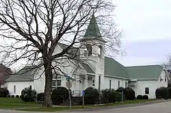 Algood Methodist Church |
November 15, 1979 (#79002454) |
158 Wall St. 36°11′37″N 85°26′57″W |
Algood | |
| 2 | The Arcade | 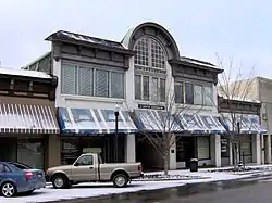 The Arcade |
April 17, 1979 (#79002455) |
7-13 S. Jefferson Ave. 36°09′45″N 85°30′01″W |
Cookeville | Currently an office building |
| 3 | Broad Street Church of Christ | 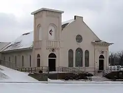 Broad Street Church of Christ |
February 1, 2002 (#01001567) |
157 E. Broad St. 36°09′48″N 85°30′57″W |
Cookeville | Now a Methodist church known as "Wesley Chapel" |
| 4 | Buffalo Valley School | 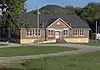 Buffalo Valley School |
July 5, 2006 (#06000548) |
2717 Buffalo Valley School Rd. 36°08′36″N 85°46′57″W |
Buffalo Valley | |
| 5 | Burgess Falls Hydroelectric Station |  Burgess Falls Hydroelectric Station |
July 5, 1990 (#90001006) |
State Route 135 over the Falling Water River 36°02′42″N 85°35′52″W |
Cookeville | Accessible from Burgess Falls State Park; TN-135 crosses the river just upstream from the dam |
| 6 | Cookeville Railroad Depot | 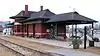 Cookeville Railroad Depot |
November 7, 1985 (#85002773) |
Broad and Cedar Sts. 36°09′51″N 85°30′30″W |
Cookeville | Now a museum |
| 7 | Cowen Farmstead | 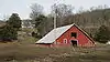 Cowen Farmstead |
March 25, 2005 (#05000205) |
2671 Little Indian Creek Rd. 36°12′52″N 85°44′08″W |
Buffalo Valley | Now a red angus ranch known as Heritage Farms |
| 8 | First Presbyterian Church |  First Presbyterian Church |
December 27, 2010 (#10001060) |
20 N. Dixie Ave. 36°09′48″N 85°30′08″W |
Cookeville | Congregation founded in 1867, current church built in 1910 |
| 9 | Harding Studio | 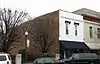 Harding Studio |
April 21, 1992 (#92000355) |
43 W. Broad St. 36°09′51″N 85°30′26″W |
Cookeville | Used as a photography studio by the Harding family, 1914-1974 |
| 10 | Henderson Hall | 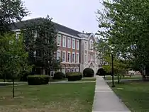 Henderson Hall |
November 7, 1985 (#85002754) |
Tennessee Technological University, Dixie Ave. 36°10′30″N 85°30′18″W |
Cookeville | Houses Tennessee Tech's History and English department offices; designed by R. H. Hunt |
| 11 | John's Place | 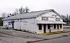 John's Place |
March 15, 2011 (#11000085) |
11 Gibson Ave. 36°10′03″N 85°30′18″W |
Cookeville | Established in 1949 as a grocery store and restaurant for Cookeville's small African-American community; has been operated by the McClellan family since its establishment |
| 12 | The Science Building |  The Science Building |
April 10, 2017 (#100000858) |
1 William L. Jones Dr. 36°10′27″N 85°30′17″W |
Cookeville | Located on the campus of Tennessee Technological University; now known as the T.J. Farr Building. |
| 13 | United States Post Office and Court House | 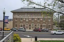 United States Post Office and Court House |
December 16, 2014 (#14001053) |
9 E. Broad St. 36°09′49″N 85°30′22″W |
Cookeville | Now called the L. Clure Morton United States Post Office and Courthouse. |
| 14 | West End Church of Christ Silver Point | 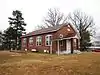 West End Church of Christ Silver Point |
December 13, 2007 (#07001270) |
14360 Center Hill Dam Rd. 36°05′26″N 85°44′26″W |
Silver Point | Evolved from Silver Point Christian Institute, established in 1909 |
| 15 | White Plains | 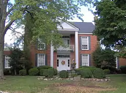 White Plains |
August 11, 2009 (#09000538) |
2700 Old Walton Rd. 36°10′39″N 85°27′01″W |
Cookeville |
See also
| Wikimedia Commons has media related to National Register of Historic Places in Putnam County, Tennessee. |
References
- The latitude and longitude information provided in this table was derived originally from the National Register Information System, which has been found to be fairly accurate for about 99% of listings. Some locations in this table may have been corrected to current GPS standards.
- "National Register of Historic Places: Weekly List Actions". National Park Service, United States Department of the Interior. Retrieved on January 29, 2021.
- Numbers represent an alphabetical ordering by significant words. Various colorings, defined here, differentiate National Historic Landmarks and historic districts from other NRHP buildings, structures, sites or objects.
- "National Register Information System". National Register of Historic Places. National Park Service. April 24, 2008.
- The eight-digit number below each date is the number assigned to each location in the National Register Information System database, which can be viewed by clicking the number.
| Topics | |
|---|---|
| Lists by state |
|
| Lists by insular areas | |
| Lists by associated state | |
| Other areas | |
| Related | |
| |
Municipalities and communities of Putnam County, Tennessee, United States | ||
|---|---|---|
| Cities | ||
| Towns | ||
| Unincorporated communities | ||
| ||
This article is issued from Wikipedia. The text is licensed under Creative Commons - Attribution - Sharealike. Additional terms may apply for the media files.