National Register of Historic Places listings in Giles County, Tennessee
This is a list of the National Register of Historic Places listings in Giles County, Tennessee.
Location of Giles County in Tennessee
This is intended to be a complete list of the properties and districts on the National Register of Historic Places in Giles County, Tennessee, United States. Latitude and longitude coordinates are provided for many National Register properties and districts; these locations may be seen together in a map.[1]
There are 33 properties and districts listed on the National Register in the county. Three previously-listed sites have been delisted.
| Anderson – Bedford – Benton – Bledsoe – Blount – Bradley – Campbell – Cannon – Carroll – Carter – Cheatham – Chester – Claiborne – Clay – Cocke – Coffee – Crockett – Cumberland – Davidson – Decatur – DeKalb – Dickson – Dyer – Fayette – Fentress – Franklin – Gibson – Giles – Grainger – Greene – Grundy – Hamblen – Hamilton – Hancock – Hardeman – Hardin – Hawkins – Haywood – Henderson – Henry – Hickman – Houston – Humphreys – Jackson – Jefferson – Johnson – Knox – Lake – Lauderdale – Lawrence – Lewis – Lincoln – Loudon – Macon – Madison – Marion – Marshall – Maury – McMinn – McNairy – Meigs – Monroe – Montgomery – Moore – Morgan – Obion – Overton – Perry – Pickett – Polk – Putnam – Rhea – Roane – Robertson – Rutherford – Scott – Sequatchie – Sevier – Shelby – Smith – Stewart – Sullivan – Sumner – Tipton – Trousdale – Unicoi – Union – Van Buren – Warren – Washington – Wayne – Weakley – White – Williamson – Wilson |
- This National Park Service list is complete through NPS recent listings posted January 29, 2021.[2]
Current listings
| [3] | Name on the Register[4] | Image | Date listed[5] | Location | City or town | Description |
|---|---|---|---|---|---|---|
| 1 | Abernathy Farm | April 19, 2001 (#01000393) |
9441 Elkton Pike 35°05′37″N 86°57′29″W |
Conway | ||
| 2 | Bass-Morrell House | November 10, 1988 (#88002615) |
State Route 293/Bryson Rd. 35°05′19″N 86°51′54″W |
Ardmore | ||
| 4 | Bodenham (Colored) School | 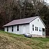 Bodenham (Colored) School |
April 5, 2006 (#06000219) |
830 Gimlet Creek Rd. 35°15′05″N 87°10′24″W |
Bodeham | |
| 5 | Bodenham Mill | 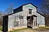 Bodenham Mill |
March 27, 2013 (#13000122) |
690 Bodenham Rd. 35°13′59″N 87°09′19″W |
Pulaski | |
| 6 | Bridgeforth High School | 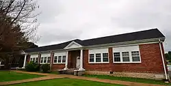 Bridgeforth High School |
August 9, 2006 (#06000697) |
1095 Bledsoe Rd. 35°12′45″N 87°01′35″W |
Pulaski | |
| 7 | Brown-Daly-Horne House | 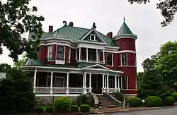 Brown-Daly-Horne House |
December 6, 1979 (#79002431) |
307 W. Madison St. 35°11′58″N 87°02′01″W |
Pulaski | |
| 8 | Campbell Chapel African Methodist Episcopal Church | .JPG.webp) Campbell Chapel African Methodist Episcopal Church |
June 22, 2000 (#00000725) |
311 Mill St.[6] 35°13′30″N 87°02′15″W |
Pulaski | |
| 9 | Church of the Messiah | 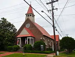 Church of the Messiah |
July 28, 1983 (#83003031) |
W. Madison and N. 3rd Sts. 35°12′00″N 87°01′59″W |
Pulaski | |
| 10 | Clifton Place | April 11, 1973 (#73001767) |
Campbellsville Rd. 35°16′05″N 87°04′24″W |
Wales | ||
| 11 | Elk River Fortification | September 29, 1998 (#98001212) |
Address Restricted |
Prospect | ||
| 12 | First Presbyterian Church of Pulaski | 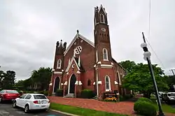 First Presbyterian Church of Pulaski |
July 28, 1983 (#83003032) |
202 S. 2nd St. 35°11′53″N 87°01′59″W |
Pulaski | |
| 13 | Matt Gardner House | July 28, 1995 (#95000942) |
U.S. Route 31 at its junction with Dixontown Rd. 35°02′46″N 86°53′11″W |
Elkton | ||
| 14 | Hallehurst | September 6, 2006 (#06000799) |
106 Little Dry Creek Rd. 35°15′13″N 87°05′22″W |
Pulaski | ||
| 15 | Austin Hewitt Home | 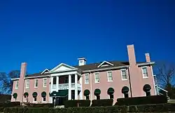 Austin Hewitt Home |
December 13, 1984 (#84000611) |
322 E. Washington St. 35°12′04″N 87°01′38″W |
Pulaski | |
| 16 | Lairdland Farm House | 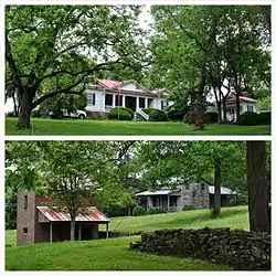 Lairdland Farm House |
September 7, 1995 (#95001088) |
3238 Blackburn Hollow Rd. 35°16′33″N 86°54′00″W |
Brick Church | |
| 17 | Lynnville Historic District | April 1, 1988 (#88000225) |
Roughly bounded by Mill St., Main, and School Rd., and Long St., the former L&N railroad line, and Water and Buggs Sts. 35°22′36″N 87°00′23″W |
Lynnville | ||
| 18 | Maplewood Cemetery | 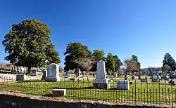 Maplewood Cemetery |
November 15, 2005 (#05000854) |
South Sam Davis Ave. 35°11′38″N 87°01′43″W |
Pulaski | |
| 19 | Milky Way Farm | 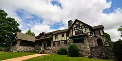 Milky Way Farm |
September 27, 1984 (#84003537) |
U.S. Route 31 35°18′37″N 87°02′15″W |
Pulaski | |
| 20 | Olivet United Methodist Church, Parsonage and School | 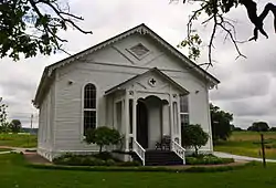 Olivet United Methodist Church, Parsonage and School |
July 19, 1984 (#84003538) |
Columbia Pike 35°17′40″N 87°01′34″W |
Riversburg | |
| 21 | Original Church of God | .JPG.webp) Original Church of God |
August 9, 2006 (#06000698) |
115 Gordon St. 35°12′34″N 87°01′41″W |
Pulaski | |
| 22 | Pisgah United Methodist Church and Cemetery | 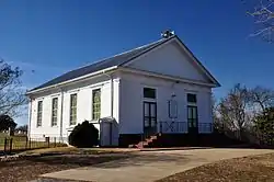 Pisgah United Methodist Church and Cemetery |
November 23, 1984 (#84000330) |
Pisgah Rd. 35°10′46″N 86°54′43″W |
Pisgah | |
| 23 | Pulaski Courthouse Square Historic District | 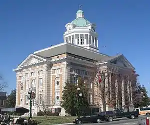 Pulaski Courthouse Square Historic District |
August 11, 1983 (#83003033) |
1st, Jefferson, Madison, and 2nd Sts.; also 114 E. Jefferson St. 35°11′59″N 87°01′52″W |
Pulaski | 114 Jefferson represents a boundary increase of July 3, 1997 |
| 24 | Reveille | .JPG.webp) Reveille |
October 28, 1994 (#94001273) |
408 W. Madison 35°12′01″N 87°02′04″W |
Pulaski | |
| 25 | Sam Davis Avenue Historic District | March 2, 1989 (#89000148) |
Sam Davis Ave. and E. Madison St. 35°11′51″N 87°01′37″W |
Pulaski | ||
| 26 | Dr. Benjamin Franklin Smith House | August 23, 2006 (#06000728) |
13494 Columbia Highway 35°22′42″N 87°01′54″W |
Waco | ||
| 27 | South Pulaski Historic District | July 10, 1986 (#86001556) |
Roughly bounded by W. College, 1st, Cemetery, and S. 3rd Sts. 35°11′41″N 87°02′02″W |
Pulaski | ||
| 28 | George W. Tillery House | 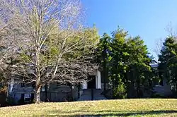 George W. Tillery House |
July 5, 1985 (#85001486) |
U.S. Route 31 35°14′10″N 87°02′35″W |
Pulaski | |
| 29 | Elisha White House |  Elisha White House |
March 4, 1983 (#83003034) |
West of Waco on Yokley Rd. 35°22′32″N 87°02′09″W |
Waco | |
| 30 | Newton White House | October 22, 1987 (#87001884) |
Old Pigeon Roost Rd. 35°13′56″N 87°01′09″W |
Pulaski | ||
| 31 | Copeland Whitfield House | 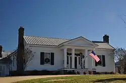 Copeland Whitfield House |
July 7, 1988 (#88001021) |
Bee Line Highway 35°10′21″N 87°00′59″W |
Pulaski | |
| 32 | Wilkerson Place | October 23, 1986 (#86002899) |
Miller Hollow Rd. 35°17′56″N 87°04′51″W |
Wales | ||
| 33 | Wilkinson-Martin House | 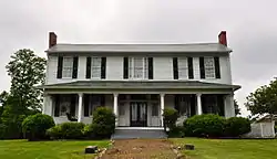 Wilkinson-Martin House |
March 17, 2010 (#10000085) |
954 N. 1st St. 35°12′31″N 87°01′37″W |
Pulaski | |
| 34 | Wilson-Young House | April 13, 1973 (#73001766) |
Southwest of Dellrose off Interstate 65 35°05′45″N 86°50′19″W |
Dellrose |
Former listings
Two other properties were once listed, but have since been removed:
| [3] | Name on the Register | Image | Date listed | Date removed | Location | City or town | Summary |
|---|---|---|---|---|---|---|---|
| 1 | Batte-Brown-Blackburn House | 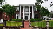 Batte-Brown-Blackburn House |
June 7, 1996 (#96000659) | March 10, 2009 | 318 W. Madison St. 35°11′59″N 87°01′55″W |
Pulaski | Currently named Grissom Colonial Hall and owned by Martin Methodist College. |
| 2 | Bethany Presbyterian Church Complex | November 13, 1989 (#89001968) | March 27, 2020 | Elkton Rd. 35°05′51″N 86°51′39″W |
Bryson | ||
| 3 | Noblit-Lytle House | August 1, 2008 (#08000734) | July 25, 2018 | 1311 Sugar Creek Rd. 35°01′38″N 87°13′00″W |
Minor Hill | Demolished in 2018. |
See also
| Wikimedia Commons has media related to National Register of Historic Places in Giles County, Tennessee. |
References
- The latitude and longitude information provided in this table was derived originally from the National Register Information System, which has been found to be fairly accurate for about 99% of listings. Some locations in this table may have been corrected to current GPS standards.
- "National Register of Historic Places: Weekly List Actions". National Park Service, United States Department of the Interior. Retrieved on January 29, 2021.
- Numbers represent an alphabetical ordering by significant words. Various colorings, defined here, differentiate National Historic Landmarks and historic districts from other NRHP buildings, structures, sites or objects.
- "National Register Information System". National Register of Historic Places. National Park Service. April 24, 2008.
- The eight-digit number below each date is the number assigned to each location in the National Register Information System database, which can be viewed by clicking the number.
- Street address is derived from this AME directory page; the NRIS lists it simply as "in Pulaski"
| Topics | |
|---|---|
| Lists by state |
|
| Lists by insular areas | |
| Lists by associated state | |
| Other areas | |
| Related | |
| |
Municipalities and communities of Giles County, Tennessee, United States | ||
|---|---|---|
| Cities | Giles County map | |
| Town | ||
| Unincorporated communities | ||
| Footnotes | ‡This populated place also has portions in an adjacent county or counties | |
| ||
This article is issued from Wikipedia. The text is licensed under Creative Commons - Attribution - Sharealike. Additional terms may apply for the media files.