National Register of Historic Places listings in Franklin County, Tennessee
This is a list of the National Register of Historic Places listings in Franklin County, Tennessee.
Location of Franklin County in Tennessee
This is intended to be a complete list of the properties and districts on the National Register of Historic Places in Franklin County, Tennessee, United States. Latitude and longitude coordinates are provided for many National Register properties and districts; these locations may be seen together in a map.[1]
There are 21 properties and districts listed on the National Register in the county. Three other previously listed sites have been removed.
| Anderson – Bedford – Benton – Bledsoe – Blount – Bradley – Campbell – Cannon – Carroll – Carter – Cheatham – Chester – Claiborne – Clay – Cocke – Coffee – Crockett – Cumberland – Davidson – Decatur – DeKalb – Dickson – Dyer – Fayette – Fentress – Franklin – Gibson – Giles – Grainger – Greene – Grundy – Hamblen – Hamilton – Hancock – Hardeman – Hardin – Hawkins – Haywood – Henderson – Henry – Hickman – Houston – Humphreys – Jackson – Jefferson – Johnson – Knox – Lake – Lauderdale – Lawrence – Lewis – Lincoln – Loudon – Macon – Madison – Marion – Marshall – Maury – McMinn – McNairy – Meigs – Monroe – Montgomery – Moore – Morgan – Obion – Overton – Perry – Pickett – Polk – Putnam – Rhea – Roane – Robertson – Rutherford – Scott – Sequatchie – Sevier – Shelby – Smith – Stewart – Sullivan – Sumner – Tipton – Trousdale – Unicoi – Union – Van Buren – Warren – Washington – Wayne – Weakley – White – Williamson – Wilson |
- This National Park Service list is complete through NPS recent listings posted February 5, 2021.[2]
Current listings
| [3] | Name on the Register[4] | Image | Date listed[5] | Location | City or town | Description |
|---|---|---|---|---|---|---|
| 1 | Asia School | 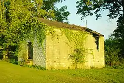 Asia School |
July 13, 2011 (#11000456) |
525 Asia Rd. 35°14′38″N 86°05′33″W |
Asia | |
| 2 | Bank of Winchester Building | 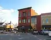 Bank of Winchester Building |
May 23, 1978 (#78002589) |
1st Ave. 35°11′09″N 86°06′44″W |
Winchester | Built in 1899; also called the Farmers National Bank Building. |
| 3 | Cowan Depot | 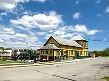 Cowan Depot |
November 24, 1978 (#78002588) |
Front St. 35°09′49″N 86°00′36″W |
Cowan | Now the Cowan Railroad Museum |
| 4 | Cumberland Mountain Tunnel |  Cumberland Mountain Tunnel |
August 22, 1977 (#77001270) |
Southeast of Cowan 35°09′10″N 85°58′32″W |
Cowan | |
| 5 | Estill-Fite House | 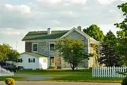 Estill-Fite House |
March 23, 1979 (#79002429) |
114 Sharp Springs Rd. 35°11′27″N 86°06′28″W |
Winchester | |
| 6 | Falls Mill | 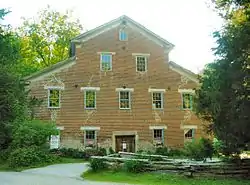 Falls Mill |
February 23, 1972 (#72001240) |
1 mile (1.6 km) off U.S. Route 64 35°05′56″N 86°15′41″W |
Huntland | |
| 7 | Falls Mills Historic District | 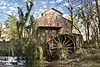 Falls Mills Historic District |
July 9, 1987 (#87001158) |
Old Salem-Lexie and Falls Mill Rds. 35°05′58″N 86°15′39″W |
Huntland | |
| 8 | Franklin County Courthouse | 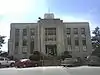 Franklin County Courthouse |
March 30, 1995 (#95000345) |
Public Sq. 35°11′11″N 86°06′43″W |
Winchester | Built in 1936; designed by Nashville-based architectural firm Marr & Holman. |
| 9 | Franklin County Jail | 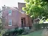 Franklin County Jail |
March 26, 1979 (#79002430) |
Decherd Boulevard 35°11′16″N 86°06′34″W |
Winchester | |
| 10 | Isaac Gray House | November 21, 1976 (#76001776) |
Southwest of Winchester off U.S. Route 64 35°06′02″N 86°15′25″W |
Winchester | ||
| 11 | Haynes House | 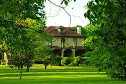 Haynes House |
April 28, 2005 (#05000359) |
519 Spring St. 35°12′44″N 86°04′16″W |
Decherd | Nomination form: |
| 12 | Hunt-Moore House |  Hunt-Moore House |
November 9, 2005 (#05001223) |
518 Main St. 35°03′18″N 86°16′13″W |
Huntland | |
| 13 | R.N. Mann House | 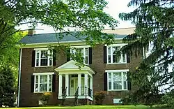 R.N. Mann House |
September 22, 1977 (#77001271) |
North of Old Salem off U.S. Route 64 35°06′03″N 86°15′25″W |
Old Salem | Nomination form: |
| 14 | Saint Margaret Mary Catholic Mission | July 10, 2017 (#100001305) |
9458 Old Alto Hwy. 35°16′12″N 85°57′29″W |
Decherd vicinity | ||
| 15 | Sewanee Fire Lookout Tower | 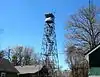 Sewanee Fire Lookout Tower |
March 31, 2015 (#15000116) |
310 Fire Tower Rd. 35°13′11″N 85°53′18″W |
Sewanee | State-owned and opened to the public as of 2016 (canopy off limits). |
| 16 | Shook-Vanzant Farm | July 31, 1998 (#98000954) |
210 Moore Farm Rd. 35°08′38″N 86°08′47″W |
Winchester | ||
| 17 | Peter Simmons House | August 16, 1977 (#77001272) |
11 miles (18 km) southwest of Winchester on U.S. Route 64 35°04′46″N 86°15′29″W |
Winchester | ||
| 18 | Tims Ford Hydroelectric Project | 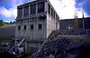 Tims Ford Hydroelectric Project |
August 11, 2017 (#100001465) |
461 Powerhouse Rd. 35°11′49″N 86°16′43″W |
Winchester | |
| 19 | Trinity Episcopal Church | 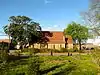 Trinity Episcopal Church |
November 25, 1980 (#80003796) |
213 1st Ave., NW. 35°11′06″N 86°06′50″W |
Winchester | Congregation established in 1859; church constructed in the early 1870s. |
| 20 | Valentine Square | 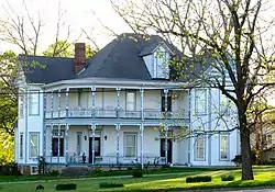 Valentine Square |
November 8, 1984 (#84000375) |
111 N. Cedar St. 35°11′04″N 86°06′56″W |
Winchester | Built in 1899 by Tullahoma builder Franklin Pierce McDowell for local banker Smith Morgan Alexander (1849–1932). |
| 21 | Zaugg Bank Barn | December 18, 1973 (#73001764) |
Southeast of Belvidere off U.S. Route 64 Additional documentation approved (listed July 17, 2012): 831 Crawford Ln., Belvidere vicinity 35°06′49″N 86°09′39″W |
Belvidere |
Former listings
| [3] | Name on the Register | Image | Date listed | Date removed | Location | City or town | Summary |
|---|---|---|---|---|---|---|---|
| 1 | Circular Barn at Cloverdale Farm | December 12, 1976 (#76001774) | Unknown | S of Belvidere off U.S. 64 |
Belvidere vicinity | ||
| 2 | Hundred Oaks Castle | 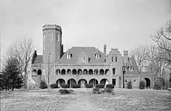 Hundred Oaks Castle |
May 28, 1975 (#75001753) | November 16, 1994 | Oak Street and US Highway 64 |
Winchester | former home of Arthur Marks, son of Governor Albert S. Marks. Significantly damaged in a fire in 1990. Delisted between June 5, 1990 and December 20, 1990, but reinstated. |
| 3 | Knies Blacksmith Shop | April 11, 1973 (#73001765) | January 29, 2013 | 118 N. Jefferson St. |
Winchester | ||
| 4 | Col. James Lewis House | November 21, 1976 (#76001775) | May 16, 1989 | East of Decherd on Greenhaw Rd. |
Decherd vicinity |
See also
| Wikimedia Commons has media related to National Register of Historic Places in Franklin County, Tennessee. |
References
- The latitude and longitude information provided in this table was derived originally from the National Register Information System, which has been found to be fairly accurate for about 99% of listings. Some locations in this table may have been corrected to current GPS standards.
- "National Register of Historic Places: Weekly List Actions". National Park Service, United States Department of the Interior. Retrieved on February 5, 2021.
- Numbers represent an alphabetical ordering by significant words. Various colorings, defined here, differentiate National Historic Landmarks and historic districts from other NRHP buildings, structures, sites or objects.
- "National Register Information System". National Register of Historic Places. National Park Service. April 24, 2008.
- The eight-digit number below each date is the number assigned to each location in the National Register Information System database, which can be viewed by clicking the number.
| Topics | |
|---|---|
| Lists by state |
|
| Lists by insular areas | |
| Lists by associated state | |
| Other areas | |
| Related | |
| |
Municipalities and communities of Franklin County, Tennessee, United States | ||
|---|---|---|
| Cities | Map of Tennessee highlighting Franklin County | |
| Towns | ||
| CDP | ||
| Unincorporated communities | ||
| Ghost town | ||
| Footnotes | ‡This populated place also has portions in an adjacent county or counties | |
| ||
This article is issued from Wikipedia. The text is licensed under Creative Commons - Attribution - Sharealike. Additional terms may apply for the media files.