National Register of Historic Places listings in Maury County, Tennessee
This is a list of the National Register of Historic Places listings in Maury County, Tennessee.
Location of Maury County in Tennessee
This is intended to be a complete list of the properties and districts on the National Register of Historic Places in Maury County, Tennessee, United States. Latitude and longitude coordinates are provided for many National Register properties and districts; these locations may be seen together in a map.[1]
There are 69 properties and districts listed on the National Register in the county, including 2 National Historic Landmarks.
| Anderson – Bedford – Benton – Bledsoe – Blount – Bradley – Campbell – Cannon – Carroll – Carter – Cheatham – Chester – Claiborne – Clay – Cocke – Coffee – Crockett – Cumberland – Davidson – Decatur – DeKalb – Dickson – Dyer – Fayette – Fentress – Franklin – Gibson – Giles – Grainger – Greene – Grundy – Hamblen – Hamilton – Hancock – Hardeman – Hardin – Hawkins – Haywood – Henderson – Henry – Hickman – Houston – Humphreys – Jackson – Jefferson – Johnson – Knox – Lake – Lauderdale – Lawrence – Lewis – Lincoln – Loudon – Macon – Madison – Marion – Marshall – Maury – McMinn – McNairy – Meigs – Monroe – Montgomery – Moore – Morgan – Obion – Overton – Perry – Pickett – Polk – Putnam – Rhea – Roane – Robertson – Rutherford – Scott – Sequatchie – Sevier – Shelby – Smith – Stewart – Sullivan – Sumner – Tipton – Trousdale – Unicoi – Union – Van Buren – Warren – Washington – Wayne – Weakley – White – Williamson – Wilson |
- This National Park Service list is complete through NPS recent listings posted January 29, 2021.[2]
Current listings
| [3] | Name on the Register[4] | Image | Date listed[5] | Location | City or town | Description |
|---|---|---|---|---|---|---|
| 1 | Jonathan Amis House | April 26, 1984 (#84003620) |
Covey Hollow Rd. 35°29′27″N 87°02′43″W |
McCains | ||
| 2 | Ashwood Rural Historic District | February 10, 1989 (#88003247) |
Spans U.S. Route 43 between Columbia and Mount Pleasant 35°34′24″N 87°08′18″W |
Columbia | ||
| 3 | The Athenaeum | 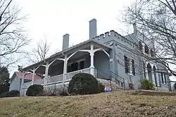 The Athenaeum |
April 24, 1973 (#73001809) |
808 Athenaeum St. 35°36′51″N 87°02′29″W |
Columbia | |
| 4 | Beechlawn Advance and Retreat | May 14, 1971 (#71000824) |
South of Columbia on U.S. Route 31 35°34′08″N 87°02′32″W |
Columbia | ||
| 5 | Blythewood | 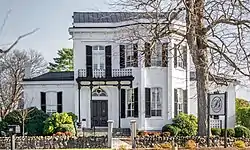 Blythewood |
April 11, 1973 (#73001810) |
Trotwood and Hatcher Lane 35°36′18″N 87°03′49″W |
Columbia | |
| 6 | Merritt H. Booker House | 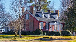 Merritt H. Booker House |
July 18, 1985 (#85001561) |
Scott Hollow Rd. 35°28′15″N 87°00′33″W |
Culleoka | |
| 7 | Breckenridge Hatter's Shop | 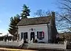 Breckenridge Hatter's Shop |
December 13, 1984 (#84000613) |
N. Main St. 35°32′07″N 87°12′23″W |
Mount Pleasant | |
| 8 | Martin Cheairs House | 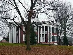 Martin Cheairs House |
December 12, 1976 (#76001787) |
U.S. Route 31 35°44′53″N 86°55′54″W |
Spring Hill | |
| 9 | Church House | 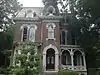 Church House |
October 19, 1978 (#78002609) |
312 W. 7th St. 35°36′56″N 87°02′19″W |
Columbia | Also known as "Barrow House" |
| 10 | Cleburne Jersey Farm | November 22, 2000 (#00001430) |
2319 Sugar Ridge Rd. 35°46′32″N 86°56′19″W |
Spring Hill | ||
| 11 | Clifton Place | Clifton Place |
July 8, 1970 (#70000613) |
Southwest of Columbia on the Mt. Pleasant Highway 35°34′40″N 87°06′52″W |
Columbia | |
| 12 | Columbia Arsenal | 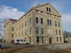 Columbia Arsenal |
September 19, 1977 (#77001281) |
W. 7th St. 35°36′53″N 87°03′30″W |
Columbia | |
| 13 | Columbia Central High School |  Columbia Central High School |
April 21, 1980 (#80003848) |
W. 8th St. 35°36′49″N 87°02′29″W |
Columbia | |
| 14 | Columbia Commercial Historic District |  Columbia Commercial Historic District |
August 16, 1984 (#84003625) |
Roughly bounded by 7th, 8th, Woodland, and High St. 35°36′50″N 87°02′04″W |
Columbia | |
| 15 | Columbia Hydroelectric Station | 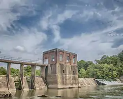 Columbia Hydroelectric Station |
February 9, 1990 (#89002364) |
Riverside Park, Riverside Dr., and the Duck River 35°36′56″N 87°00′53″W |
Columbia | |
| 16 | Columbia West End Historic District | March 13, 1986 (#86000394) |
Roughly along W. 7th St. between Frierson St. and the former Seaboard System railroad line 35°36′58″N 87°02′49″W |
Columbia | ||
| 17 | Culleoka Methodist Episcopal Church, South | 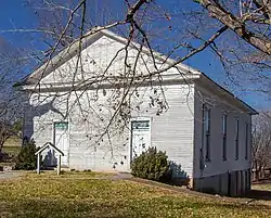 Culleoka Methodist Episcopal Church, South |
May 22, 1986 (#86001134) |
Quality St. 35°28′53″N 86°59′06″W |
Culleoka | |
| 18 | Derryberry House | November 7, 1990 (#90001656) |
New Lasea Rd. east of its junction with Interstate 65 35°40′21″N 86°52′40″W |
Spring Hill | ||
| 19 | Elm Springs | 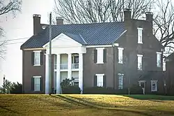 Elm Springs |
March 13, 1986 (#86000402) |
Mooresville Pike 35°35′05″N 87°01′50″W |
Columbia | |
| 20 | Ewell Farm | 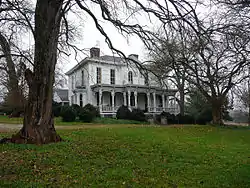 Ewell Farm |
May 24, 1976 (#76001788) |
Depot Lane 35°45′38″N 86°56′37″W |
Spring Hill | |
| 21 | Fairmont | 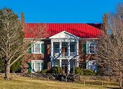 Fairmont |
September 1, 1983 (#83003052) |
Mooresville Pike 35°35′10″N 87°01′31″W |
Columbia | |
| 22 | First United Methodist Church of Columbia | 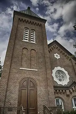 First United Methodist Church of Columbia |
August 30, 1984 (#84003628) |
222 W. 7th St. 35°36′55″N 87°02′11″W |
Columbia | |
| 23 | Lucius Frierson House | September 1, 1978 (#78002610) |
W. 7th St. 35°36′57″N 87°02′25″W |
Columbia | ||
| 24 | John Gordon House | 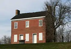 John Gordon House |
April 18, 1974 (#74000333) |
Northwest of Williamsport off State Route 50 35°43′11″N 87°15′38″W |
Williamsport | |
| 25 | Grace Episcopal Church | 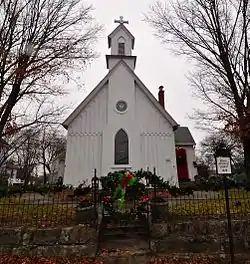 Grace Episcopal Church |
May 17, 1976 (#76001789) |
U.S. Route 31 35°45′09″N 86°55′45″W |
Spring Hill | |
| 26 | Hamilton Place | July 16, 1973 (#73001812) |
Mt. Pleasant Pike, west of Columbia off U.S. Route 43 35°34′18″N 87°09′11″W |
Columbia | ||
| 27 | Hardison Mill Farm | November 13, 2017 (#100001826) |
4554 US 431 35°36′53″N 86°49′24″W |
Columbia vicinity | ||
| 28 | James Kennedy House | November 6, 1987 (#87001780) |
Rogers Ford Rd. 35°39′25″N 86°59′45″W |
Columbia | ||
| 29 | Patrick Maguire House |  Patrick Maguire House |
December 15, 1983 (#83004270) |
105 N. Campbell Boulevard 35°37′34″N 87°02′28″W |
Columbia | |
| 30 | Dr. Samuel Mayes House | October 25, 1993 (#93000345) |
Junction of Zion Ln. and Canaan Rd. 35°36′00″N 87°10′53″W |
Columbia | ||
| 31 | Mayes-Hutton House |  Mayes-Hutton House |
July 8, 1970 (#70000614) |
306 W. 6th St. 35°37′01″N 87°02′17″W |
Columbia | |
| 32 | Mercer Hall | .jpg.webp) Mercer Hall |
December 16, 1982 (#82001730) |
902 Mercer Ct. 35°36′35″N 87°02′46″W |
Columbia | |
| 33 | Washington Miller House | November 14, 2012 (#12000944) |
1450 Frye Rd. 35°42′04″N 86°59′25″W |
Columbia | ||
| 34 | Mount Pleasant Commercial Historic District | November 13, 2003 (#03001160) |
Roughly bounded by N. and S. Main Sts., Public Sq., and Hay Long Ave. 35°32′05″N 87°12′26″W |
Mount Pleasant | ||
| 35 | North Main Street Historic District | August 8, 1989 (#89000263) |
Roughly N. Main St. from Shofner St. to 3rd St. 35°32′24″N 87°12′14″W |
Mount Pleasant | ||
| 36 | Old Natchez Trace |  Old Natchez Trace |
May 30, 1975 (#75002125) |
From the Alabama/Tennessee border to State Route 100 in Davidson County Coordinates missing |
Santa Fe | Extends into Davidson, Hickman, Lawrence, Lewis, Wayne, and Williamson counties |
| 37 | Pillow Place | December 8, 1983 (#83004271) |
Campbellsville Pike 35°34′17″N 87°04′52″W |
Columbia | ||
| 38 | Pillow-Bethel House | December 12, 1976 (#76001785) |
Southwest of Columbia off U.S. Route 43 35°34′05″N 87°06′56″W |
Columbia | ||
| 39 | Pine Hill |  Pine Hill |
December 15, 1983 (#83004272) |
Old Zion Lane 35°35′11″N 87°07′39″W |
Ashwood | |
| 40 | Pleasant Historic District | August 8, 1989 (#89000264) |
Roughly bounded by Haylong Ave., Pleasant, Bond, Wheeler, Adams, and Cherry Sts., Washington Ave., and College St. 35°32′06″N 87°12′48″W |
Mount Pleasant | ||
| 41 | Pleasant Mount Cumberland Presbyterian Church | 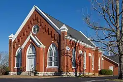 Pleasant Mount Cumberland Presbyterian Church |
August 16, 1977 (#77001282) |
Southeast of Columbia off State Route 50 35°32′32″N 86°58′08″W |
Columbia | |
| 42 | Polk Sisters' House | 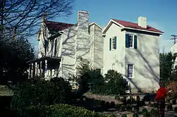 Polk Sisters' House |
May 21, 1975 (#75001770) |
305 W. 7th St. 35°36′54″N 87°02′16″W |
Columbia | |
| 43 | James K. Polk Home | 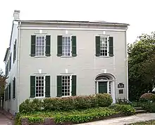 James K. Polk Home |
October 15, 1966 (#66000728) |
W. 7th and S. High Sts. 35°36′54″N 87°02′14″W |
Columbia | |
| 44 | Pottsville General Store | Pottsville General Store |
November 14, 2017 (#100001827) |
4205 US 431 35°38′16″N 86°49′31″W |
Columbia vicinity | |
| 45 | Prewitt-Amis-Finney House | 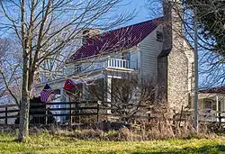 Prewitt-Amis-Finney House |
December 1, 1997 (#97001503) |
2629 Pullen Mill Rd. 35°27′44″N 87°00′02″W |
Culleoka | |
| 46 | Rally Hill | 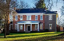 Rally Hill |
August 16, 1984 (#84003638) |
319 W. 8th St. 35°36′48″N 87°02′20″W |
Columbia | |
| 47 | Rattle and Snap | .jpg.webp) Rattle and Snap |
November 11, 1971 (#71000825) |
Andrew Jackson Highway (State Route 43) 35°33′38″N 87°09′12″W |
Columbia | |
| 48 | Rippavilla |  Rippavilla |
July 19, 1996 (#96000773) |
U.S. Route 31, approximately 1.5 miles south of its junction with Kedron Rd. 35°43′54″N 86°57′14″W |
Spring Hill | |
| 49 | Ritter-Morton House | 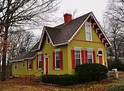 Ritter-Morton House |
December 12, 1976 (#76001790) |
McLemore Ave. 35°45′02″N 86°55′45″W |
Spring Hill | |
| 50 | Rockdale Furnace Historic District (40MU487) | July 21, 1988 (#88001100) |
Address Restricted |
Rockdale | ||
| 51 | St. John's Episcopal Church | 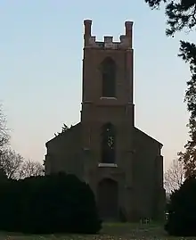 St. John's Episcopal Church |
July 8, 1970 (#70000615) |
West of Columbia on U.S. Route 43 35°34′27″N 87°08′20″W |
Columbia | |
| 52 | St. Mark United Primitive Baptist Church | 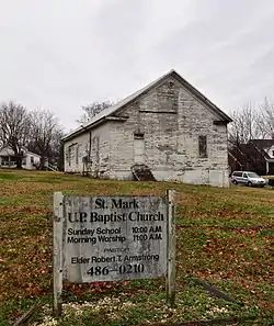 St. Mark United Primitive Baptist Church |
July 14, 2000 (#00000811) |
Maury Hill St. 35°45′01″N 86°55′58″W |
Spring Hill | |
| 53 | St. Peter's Episcopal Church | 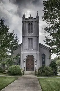 St. Peter's Episcopal Church |
June 27, 1979 (#79002448) |
311 W. 7th St. 35°36′52″N 87°02′18″W |
Columbia | |
| 54 | Andrew Scott House | 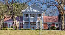 Andrew Scott House |
August 4, 1995 (#95000976) |
3991 Pulaski Highway 35°27′57″N 87°02′31″W |
Culleoka | |
| 55 | Shelby Bend Archeological District | February 1, 1990 (#89001760) |
Address Restricted |
Greenfield Bend | Extends into Hickman County | |
| 56 | Skipwith Hall | 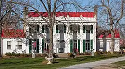 Skipwith Hall |
November 23, 1977 (#77001283) |
West of Columbia on State Route 50 35°38′29″N 87°08′35″W |
Columbia | |
| 57 | Spring Hill Presbyterian Church | 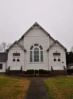 Spring Hill Presbyterian Church |
July 19, 1984 (#84003640) |
S. Main St. 35°44′56″N 86°55′52″W |
Spring Hill | |
| 58 | State Bank of Tennessee | November 2, 1978 (#78002611) |
201 W. 7th St. 35°36′53″N 87°02′09″W |
Columbia | ||
| 59 | Absalom Thompson House | September 11, 1979 (#79002449) |
South of Spring Hill on Denning Rd 35°43′19″N 86°55′47″W |
Spring Hill | ||
| 60 | Union Station | 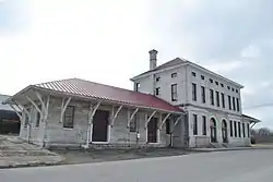 Union Station |
October 23, 1986 (#86002908) |
Depot St. 35°36′29″N 87°02′14″W |
Columbia | |
| 61 | United States Post Office and Court House | September 11, 2018 (#100002938) |
815 S Garden St. 35°36′50″N 87°02′09″W |
Columbia | ||
| 62 | Vine Hill |  Vine Hill |
July 15, 1983 (#83003053) |
Sawdust Rd. 35°38′47″N 87°12′47″W |
Cross Bridges | |
| 63 | Walnut Grove |  Walnut Grove |
March 8, 1984 (#84003641) |
510 N. Main St. 35°32′25″N 87°12′11″W |
Mount Pleasant | |
| 64 | William Watkins House | October 23, 1986 (#86002901) |
Canaan Rd. 35°33′53″N 87°11′39″W |
Mount Pleasant | ||
| 65 | Webster Farm |  Webster Farm |
July 19, 1996 (#96000770) |
3166 Hampshire Pike 35°37′19″N 87°13′15″W |
Cross Bridges | |
| 66 | George Webster House | April 5, 1984 (#84003646) |
Sawdust Rd. 35°38′02″N 87°12′44″W |
Williamsport | ||
| 67 | West Sixth Street and Mayes Place Historic District | February 25, 1978 (#78002612) |
W. 6th St. and Mayes Pl. 35°37′00″N 87°02′18″W |
Columbia | ||
| 68 | White Hall |  White Hall |
April 5, 1984 (#84003661) |
Duplex Rd. 35°45′08″N 86°55′32″W |
Spring Hill | |
| 69 | Zion Presbyterian Church | %252C_State_Route_1%252C_Columbia_vicinity_(Maury_County%252C_Tennessee).jpg.webp) Zion Presbyterian Church |
June 13, 1972 (#72001245) |
6.3 miles west of Columbia off State Route 99 35°35′56″N 87°08′42″W |
Columbia |
Former listings
| [3] | Name on the Register | Image | Date listed | Date removed | Location | City or town | Summary |
|---|---|---|---|---|---|---|---|
| 1 | Cherry Glen | July 2, 1973 (#73002243) | June 10, 1985 | SW of Columbia off US 43 |
Columbia |
See also
| Wikimedia Commons has media related to National Register of Historic Places in Maury County, Tennessee. |
References
- The latitude and longitude information provided in this table was derived originally from the National Register Information System, which has been found to be fairly accurate for about 99% of listings. Some locations in this table may have been corrected to current GPS standards.
- "National Register of Historic Places: Weekly List Actions". National Park Service, United States Department of the Interior. Retrieved on January 29, 2021.
- Numbers represent an alphabetical ordering by significant words. Various colorings, defined here, differentiate National Historic Landmarks and historic districts from other NRHP buildings, structures, sites or objects.
- "National Register Information System". National Register of Historic Places. National Park Service. April 24, 2008.
- The eight-digit number below each date is the number assigned to each location in the National Register Information System database, which can be viewed by clicking the number.
| Topics | |
|---|---|
| Lists by state |
|
| Lists by insular areas | |
| Lists by associated state | |
| Other areas | |
| Related | |
| |
Municipalities and communities of Maury County, Tennessee, United States | ||
|---|---|---|
| Cities | Maury County map | |
| Unincorporated communities | ||
| Footnotes | ‡This populated place also has portions in an adjacent county or counties | |
| ||
This article is issued from Wikipedia. The text is licensed under Creative Commons - Attribution - Sharealike. Additional terms may apply for the media files.