National Register of Historic Places listings in Humphreys County, Tennessee
This is a list of the National Register of Historic Places listings in Humphreys County, Tennessee.
Location of Humphreys County in Tennessee
This is intended to be a complete list of the properties and districts on the National Register of Historic Places in Humphreys County, Tennessee, United States. Latitude and longitude coordinates are provided for many National Register properties and districts; these locations may be seen together in a map.[1]
There are 10 properties and districts listed on the National Register in the county.
| Anderson – Bedford – Benton – Bledsoe – Blount – Bradley – Campbell – Cannon – Carroll – Carter – Cheatham – Chester – Claiborne – Clay – Cocke – Coffee – Crockett – Cumberland – Davidson – Decatur – DeKalb – Dickson – Dyer – Fayette – Fentress – Franklin – Gibson – Giles – Grainger – Greene – Grundy – Hamblen – Hamilton – Hancock – Hardeman – Hardin – Hawkins – Haywood – Henderson – Henry – Hickman – Houston – Humphreys – Jackson – Jefferson – Johnson – Knox – Lake – Lauderdale – Lawrence – Lewis – Lincoln – Loudon – Macon – Madison – Marion – Marshall – Maury – McMinn – McNairy – Meigs – Monroe – Montgomery – Moore – Morgan – Obion – Overton – Perry – Pickett – Polk – Putnam – Rhea – Roane – Robertson – Rutherford – Scott – Sequatchie – Sevier – Shelby – Smith – Stewart – Sullivan – Sumner – Tipton – Trousdale – Unicoi – Union – Van Buren – Warren – Washington – Wayne – Weakley – White – Williamson – Wilson |
- This National Park Service list is complete through NPS recent listings posted February 5, 2021.[2]
Current listings
| [3] | Name on the Register[4] | Image | Date listed[5] | Location | City or town | Description |
|---|---|---|---|---|---|---|
| 1 | Enochs Mill | September 9, 1999 (#99001138) |
3072 Little Blue Creek Rd. 36°04′42″N 87°41′12″W |
McEwen | ||
| 2 | Fairchance Furnace (40HS168) | July 28, 1988 (#88001143) |
Address Restricted |
Halls Creek | ||
| 3 | Fort Hill and Archibald D. Butterfield House |  Fort Hill and Archibald D. Butterfield House |
February 9, 2001 (#01000101) |
201 Fort Hill Dr. 36°04′54″N 87°47′32″W |
Waverly | |
| 4 | Greyhound Half-Way House |  Greyhound Half-Way House |
December 17, 1999 (#99001588) |
124 E. Main St. 36°04′58″N 87°47′34″W |
Waverly | |
| 5 | Hurricane Mills Rural Historic District | December 13, 1999 (#99001449) |
44 Hurricane Mills Rd. 35°57′53″N 87°47′08″W |
Hurricane Mills | ||
| 6 | Johnsonville Historic District | March 12, 2001 (#01000257) |
Old Johnsonville Rd. 36°03′31″N 87°58′33″W |
Denver | ||
| 7 | Link Farm Site | April 11, 1973 (#73001791) |
Address Restricted |
Hurricane Mills | ||
| 8 | Hugh M. McAdoo House | 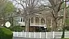 Hugh M. McAdoo House |
October 29, 1991 (#91001595) |
113 N. Church St. 36°05′03″N 87°47′36″W |
Waverly | |
| 9 | James N. Nolan House |  James N. Nolan House |
March 13, 1986 (#86000395) |
State Route 13N 36°05′17″N 87°47′37″W |
Waverly | |
| 10 | Sycamore Landing | January 4, 1980 (#80003837) |
Sycamore Landing Rd. 35°56′09″N 87°54′54″W |
Sycamore Landing |
See also
| Wikimedia Commons has media related to National Register of Historic Places in Humphreys County, Tennessee. |
References
- The latitude and longitude information provided in this table was derived originally from the National Register Information System, which has been found to be fairly accurate for about 99% of listings. Some locations in this table may have been corrected to current GPS standards.
- "National Register of Historic Places: Weekly List Actions". National Park Service, United States Department of the Interior. Retrieved on February 5, 2021.
- Numbers represent an alphabetical ordering by significant words. Various colorings, defined here, differentiate National Historic Landmarks and historic districts from other NRHP buildings, structures, sites or objects.
- "National Register Information System". National Register of Historic Places. National Park Service. April 24, 2008.
- The eight-digit number below each date is the number assigned to each location in the National Register Information System database, which can be viewed by clicking the number.
| Topics | |
|---|---|
| Lists by state |
|
| Lists by insular areas | |
| Lists by associated state | |
| Other areas | |
| Related | |
| |
Municipalities and communities of Humphreys County, Tennessee, United States | ||
|---|---|---|
| Cities | ||
| Unincorporated communities | ||
| ||
This article is issued from Wikipedia. The text is licensed under Creative Commons - Attribution - Sharealike. Additional terms may apply for the media files.