National Register of Historic Places listings in Greene County, Tennessee
This is a list of the National Register of Historic Places listings in Greene County, Tennessee.
Location of Greene County in Tennessee
This is intended to be a complete list of the properties and districts on the National Register of Historic Places in Greene County, Tennessee, United States. Latitude and longitude coordinates are provided for many National Register properties and districts; these locations may be seen together in a map.[1]
There are 17 properties and districts listed on the National Register in the county. Two other sites once listed on the Register have been removed.
| Anderson – Bedford – Benton – Bledsoe – Blount – Bradley – Campbell – Cannon – Carroll – Carter – Cheatham – Chester – Claiborne – Clay – Cocke – Coffee – Crockett – Cumberland – Davidson – Decatur – DeKalb – Dickson – Dyer – Fayette – Fentress – Franklin – Gibson – Giles – Grainger – Greene – Grundy – Hamblen – Hamilton – Hancock – Hardeman – Hardin – Hawkins – Haywood – Henderson – Henry – Hickman – Houston – Humphreys – Jackson – Jefferson – Johnson – Knox – Lake – Lauderdale – Lawrence – Lewis – Lincoln – Loudon – Macon – Madison – Marion – Marshall – Maury – McMinn – McNairy – Meigs – Monroe – Montgomery – Moore – Morgan – Obion – Overton – Perry – Pickett – Polk – Putnam – Rhea – Roane – Robertson – Rutherford – Scott – Sequatchie – Sevier – Shelby – Smith – Stewart – Sullivan – Sumner – Tipton – Trousdale – Unicoi – Union – Van Buren – Warren – Washington – Wayne – Weakley – White – Williamson – Wilson |
- This National Park Service list is complete through NPS recent listings posted January 29, 2021.[2]
Current listings
| [3] | Name on the Register[4] | Image | Date listed[5] | Location | City or town | Description |
|---|---|---|---|---|---|---|
| 1 | Allen-Birdwell Farm |  Allen-Birdwell Farm |
March 15, 2011 (#11000088) |
3005 W. Allen's Bridge Rd. 36°03′34″N 82°54′43″W |
Greeneville | Transformation of the Nolichucky Valley MPS |
| 2 | Andrew Johnson National Historic Site | 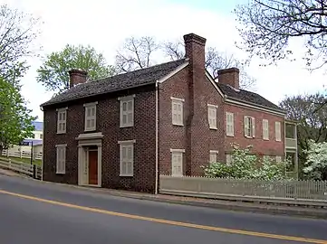 Andrew Johnson National Historic Site |
October 15, 1966 (#66000073) |
Main, Depot and College Sts. 36°09′30″N 82°50′06″W |
Greeneville | |
| 3 | Blue Springs Lutheran Church and Cemetery | 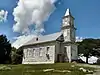 Blue Springs Lutheran Church and Cemetery |
November 13, 2017 (#100001824) |
920 Main St. 36°11′24″N 82°57′28″W |
Mosheim | |
| 4 | Brown-Neas House | 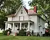 Brown-Neas House |
November 8, 1984 (#84000374) |
Old Johnson City Rd. 36°11′02″N 82°44′04″W |
Afton | Built c. 1868 by local farmer John Brown; Inventory form. |
| 5 | Bulls Gap Fortification | September 29, 1998 (#98001211) |
Address Restricted |
Bulls Gap | ||
| 6 | Conway Bridge |  Conway Bridge |
November 20, 2009 (#09000948) |
Briar Thicket Rd./Knob Creek Rd. over the Nolichucky River 36°07′21″N 83°07′31″W |
Briar Thicket | Extends into Cocke County[4] |
| 7 | Crescent School | 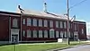 Crescent School |
March 16, 2020 (#100005134) |
615 West Main St. 36°09′29″N 82°50′24″W |
Greeneville | |
| 8 | Samuel Doak House | 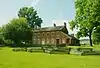 Samuel Doak House |
February 18, 1975 (#75001755) |
Erwin Highway, Greeneville, TN 37745 36°10′28″N 82°45′54″W |
Tusculum | Built by Samuel W. Doak, son of pioneer minister Samuel Doak; now a museum. |
| 9 | Earnest Farms Historic District |  Earnest Farms Historic District |
January 11, 2002 (#01001449) |
South of the Nolichucky River, bounded by Crum Farm and Jim Earnest Farmstead 36°11′54″N 82°40′51″W |
Chuckey | |
| 10 | Greeneville Historic District | 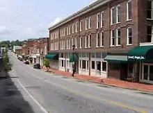 Greeneville Historic District |
May 3, 1974 (#74001913) |
Roughly bounded by Irish, Nelson, E. Church, College and McKee Sts. 36°09′41″N 82°49′47″W |
Greeneville | |
| 11 | James Lowry House | March 25, 1982 (#82003972) |
Asheville Highway 36°07′16″N 82°51′39″W |
Greeneville | ||
| 12 | Maden Hall Farm | 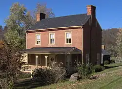 Maden Hall Farm |
August 27, 2009 (#09000667) |
3225 Kingsport Highway 36°13′02″N 82°47′40″W |
Greeneville | |
| 13 | Mauris-Earnest Fort House | 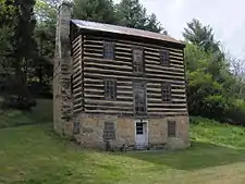 Mauris-Earnest Fort House |
January 30, 1978 (#78002591) |
South of Chuckey on the Nolichucky River 36°12′19″N 82°41′04″W |
Chuckey | |
| 14 | New Bethel Cumberland Presbyterian Church | 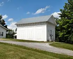 New Bethel Cumberland Presbyterian Church |
October 5, 1978 (#78002592) |
Northwest of Greeneville on State Route 70 36°11′43″N 82°53′01″W |
Greeneville | Inventory form |
| 15 | David Rankin House | 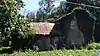 David Rankin House |
August 26, 1983 (#83003035) |
Snapp's Ferry Rd. 36°12′30″N 82°46′12″W |
Greeneville | |
| 16 | Ripley Stone House | 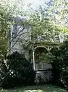 Ripley Stone House |
September 18, 1978 (#78002590) |
East of Afton off U.S. Route 11E 36°11′53″N 82°42′31″W |
Afton | |
| 17 | Tusculum College Historic District | .jpg.webp) Tusculum College Historic District |
November 25, 1980 (#80003800) |
Erwin Highway, Giland St. and Shiloh Rd. 36°10′25″N 82°45′41″W |
Tusculum |
Former listings
| [3] | Name on the Register | Image | Date listed | Date removed | Location | City or town | Summary |
|---|---|---|---|---|---|---|---|
| 1 | Chuckey Depot | 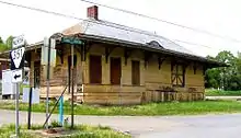 Chuckey Depot |
December 19, 1979 (#79002432) | December 15, 2011 | State Route 351 36°12′41″N 82°41′15″W |
Chuckey | |
| 2 | Wayside | March 22, 1984 (#84003543) | November 9, 2007 | East of Greeneville off of US 11E |
Greeneville |
See also
| Wikimedia Commons has media related to National Register of Historic Places in Greene County, Tennessee. |
References
- The latitude and longitude information provided in this table was derived originally from the National Register Information System, which has been found to be fairly accurate for about 99% of listings. Some locations in this table may have been corrected to current GPS standards.
- "National Register of Historic Places: Weekly List Actions". National Park Service, United States Department of the Interior. Retrieved on January 29, 2021.
- Numbers represent an alphabetical ordering by significant words. Various colorings, defined here, differentiate National Historic Landmarks and historic districts from other NRHP buildings, structures, sites or objects.
- "National Register Information System". National Register of Historic Places. National Park Service. April 24, 2008.
- The eight-digit number below each date is the number assigned to each location in the National Register Information System database, which can be viewed by clicking the number.
Municipalities and communities of Greene County, Tennessee, United States | ||
|---|---|---|
| City | Greene County map | |
| Towns | ||
| CDP | ||
| Unincorporated communities | ||
| Footnotes | ‡This populated place also has portions in an adjacent county or counties | |
| ||
| Topics | |
|---|---|
| Lists by state |
|
| Lists by insular areas | |
| Lists by associated state | |
| Other areas | |
| Related | |
| |
This article is issued from Wikipedia. The text is licensed under Creative Commons - Attribution - Sharealike. Additional terms may apply for the media files.