National Register of Historic Places listings in Lincoln County, Tennessee
This is a list of the National Register of Historic Places listings in Lincoln County, Tennessee.
Location of Lincoln County in Tennessee
This is intended to be a complete list of the properties and districts on the National Register of Historic Places in Lincoln County, Tennessee, United States. Latitude and longitude coordinates are provided for many National Register properties and districts; these locations may be seen together in a map.[1]
There are 16 properties and districts listed on the National Register in the county.
| Anderson – Bedford – Benton – Bledsoe – Blount – Bradley – Campbell – Cannon – Carroll – Carter – Cheatham – Chester – Claiborne – Clay – Cocke – Coffee – Crockett – Cumberland – Davidson – Decatur – DeKalb – Dickson – Dyer – Fayette – Fentress – Franklin – Gibson – Giles – Grainger – Greene – Grundy – Hamblen – Hamilton – Hancock – Hardeman – Hardin – Hawkins – Haywood – Henderson – Henry – Hickman – Houston – Humphreys – Jackson – Jefferson – Johnson – Knox – Lake – Lauderdale – Lawrence – Lewis – Lincoln – Loudon – Macon – Madison – Marion – Marshall – Maury – McMinn – McNairy – Meigs – Monroe – Montgomery – Moore – Morgan – Obion – Overton – Perry – Pickett – Polk – Putnam – Rhea – Roane – Robertson – Rutherford – Scott – Sequatchie – Sevier – Shelby – Smith – Stewart – Sullivan – Sumner – Tipton – Trousdale – Unicoi – Union – Van Buren – Warren – Washington – Wayne – Weakley – White – Williamson – Wilson |
- This National Park Service list is complete through NPS recent listings posted January 29, 2021.[2]
Current listings
| [3] | Name on the Register[4] | Image | Date listed[5] | Location | City or town | Description |
|---|---|---|---|---|---|---|
| 1 | Borden Powdered Milk Plant |  Borden Powdered Milk Plant |
July 14, 1988 (#88001060) |
S. Main St. 35°08′08″N 88°33′21″W |
Fayetteville | |
| 2 | Childress House | February 25, 1982 (#82003985) |
9 miles west of Fayetteville on U.S. Route 64 35°12′01″N 86°43′03″W |
Fayetteville | ||
| 3 | Isaac Conger House | July 16, 1973 (#73001807) |
Northeast of Fayetteville off Hamestring Rd. 35°13′13″N 86°30′25″W |
Fayetteville | ||
| 4 | Hugh Bright Douglas House | 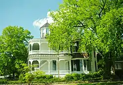 Hugh Bright Douglas House |
March 25, 1982 (#82003986) |
301 Elk Ave., N. 35°09′15″N 86°34′47″W |
Fayetteville | |
| 5 | Harms Mill Hydroelectric Station | July 5, 1990 (#90001007) |
State Route 15 at the Elk River 35°09′02″N 86°38′55″W |
Fayetteville | ||
| 6 | Harris-Holden House | March 19, 1975 (#75001766) |
East of Howell on Daves Hollow Rd. 35°13′45″N 86°36′23″W |
Howell | ||
| 7 | Kelso Bowstring Arch Truss Bridge | January 4, 1983 (#83003046) |
North of Kelso on Stephens Creek Rd. 35°08′17″N 86°28′07″W |
Kelso | ||
| 8 | Lincoln County Poor House Farm | July 11, 1985 (#85001511) |
Poorhouse Rd. 35°03′59″N 86°40′46″W |
Coldwater | ||
| 9 | McDonald-Bolner House |  McDonald-Bolner House |
May 31, 1984 (#84003579) |
400 S. Elk 35°08′57″N 86°34′10″W |
Fayetteville | |
| 10 | Mimosa School | July 28, 1983 (#83003047) |
Mimosa Rd. 35°13′31″N 86°31′12″W |
Mimosa | ||
| 11 | Mount Zion Missionary Baptist Church |  Mount Zion Missionary Baptist Church |
July 6, 2000 (#00000731) |
305 W. Maple St. 35°09′00″N 86°34′26″W |
Fayetteville | |
| 12 | Mulbery-Washington-Lincoln Historic District | 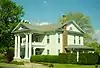 Mulbery-Washington-Lincoln Historic District |
May 31, 1984 (#84003580) |
Roughly Bright, Elk, Green, Main, Lincoln, Mulberry, and Washington Sts. 35°09′18″N 86°34′01″W |
Fayetteville | |
| 13 | Petersburg Historic District | November 7, 1985 (#85002753) |
Roughly bounded by Church, Railroad, and Gaunt Sts. and State Route 50 35°19′03″N 86°38′19″W |
Petersburg | Extends into Marshall County | |
| 14 | St. Paul African Methodist Episcopal Church | 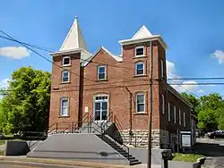 St. Paul African Methodist Episcopal Church |
October 3, 2003 (#03001003) |
521 W. College St. 35°09′11″N 86°34′39″W |
Fayetteville | |
| 15 | South Elk Street Historic District |  South Elk Street Historic District |
July 12, 1989 (#89000127) |
Roughly bounded by E. Campbell St., Franklin St., former L&N railroad tracks, and S. Elk St. 35°08′56″N 86°34′08″W |
Fayetteville | |
| 16 | Whitaker-Motlow House | 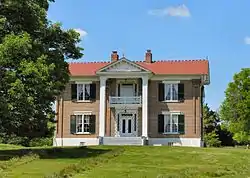 Whitaker-Motlow House |
November 15, 2011 (#11000807) |
740 Lynchburg Hwy. 35°13′30″N 86°25′55″W |
Mulberry |
See also
| Wikimedia Commons has media related to National Register of Historic Places in Lincoln County, Tennessee. |
References
- The latitude and longitude information provided in this table was derived originally from the National Register Information System, which has been found to be fairly accurate for about 99% of listings. Some locations in this table may have been corrected to current GPS standards.
- "National Register of Historic Places: Weekly List Actions". National Park Service, United States Department of the Interior. Retrieved on January 29, 2021.
- Numbers represent an alphabetical ordering by significant words. Various colorings, defined here, differentiate National Historic Landmarks and historic districts from other NRHP buildings, structures, sites or objects.
- "National Register Information System". National Register of Historic Places. National Park Service. April 24, 2008.
- The eight-digit number below each date is the number assigned to each location in the National Register Information System database, which can be viewed by clicking the number.
| Topics | |
|---|---|
| Lists by state |
|
| Lists by insular areas | |
| Lists by associated state | |
| Other areas | |
| Related | |
| |
Municipalities and communities of Lincoln County, Tennessee, United States | ||
|---|---|---|
| Cities | Lincoln County map | |
| Town | ||
| CDPs | ||
| Unincorporated communities | ||
| Footnotes | ‡This populated place also has portions in an adjacent county or counties | |
| ||
This article is issued from Wikipedia. The text is licensed under Creative Commons - Attribution - Sharealike. Additional terms may apply for the media files.