National Register of Historic Places listings in Marion County, Tennessee
This is a list of the National Register of Historic Places listings in Marion County, Tennessee.
Location of Marion County in Tennessee
This is intended to be a complete list of the properties and districts on the National Register of Historic Places in Marion County, Tennessee, United States. Latitude and longitude coordinates are provided for many National Register properties and districts; these locations may be seen together in a map.[1]
There are 16 properties and districts listed on the National Register in the county. Another two properties were once listed but has been removed.
| Anderson – Bedford – Benton – Bledsoe – Blount – Bradley – Campbell – Cannon – Carroll – Carter – Cheatham – Chester – Claiborne – Clay – Cocke – Coffee – Crockett – Cumberland – Davidson – Decatur – DeKalb – Dickson – Dyer – Fayette – Fentress – Franklin – Gibson – Giles – Grainger – Greene – Grundy – Hamblen – Hamilton – Hancock – Hardeman – Hardin – Hawkins – Haywood – Henderson – Henry – Hickman – Houston – Humphreys – Jackson – Jefferson – Johnson – Knox – Lake – Lauderdale – Lawrence – Lewis – Lincoln – Loudon – Macon – Madison – Marion – Marshall – Maury – McMinn – McNairy – Meigs – Monroe – Montgomery – Moore – Morgan – Obion – Overton – Perry – Pickett – Polk – Putnam – Rhea – Roane – Robertson – Rutherford – Scott – Sequatchie – Sevier – Shelby – Smith – Stewart – Sullivan – Sumner – Tipton – Trousdale – Unicoi – Union – Van Buren – Warren – Washington – Wayne – Weakley – White – Williamson – Wilson |
- This National Park Service list is complete through NPS recent listings posted January 29, 2021.[2]
Current listings
| [3] | Name on the Register[4] | Image | Date listed[5] | Location | City or town | Description |
|---|---|---|---|---|---|---|
| 1 | Christ Episcopal Church and Parish House | 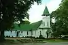 Christ Episcopal Church and Parish House |
August 22, 1977 (#77001278) |
Corner of 3rd and Holly Sts. 35°00′48″N 85°42′26″W |
South Pittsburg | |
| 2 | Ebenezer Cumberland Presbyterian Church | June 15, 2020 (#100004698) |
3040 Griffith Hwy. 35°04′26″N 85°33′37″W |
Jasper vicinity | ||
| 3 | First National Bank of South Pittsburg | 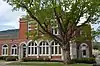 First National Bank of South Pittsburg |
June 24, 1991 (#91000826) |
204 W. 3rd St. 35°00′47″N 85°42′22″W |
South Pittsburg | Currently South Pittsburg City Hall |
| 4 | Hale's Bar Dam Powerhouse | 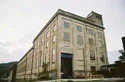 Hale's Bar Dam Powerhouse |
November 25, 2008 (#08001111) |
1265 Hale's Bar Rd. 35°02′48″N 85°32′14″W |
Haletown | |
| 5 | Richard Hardy Memorial School |  Richard Hardy Memorial School |
September 30, 1982 (#82003990) |
1620 Hamilton Ave. 34°59′43″N 85°43′14″W |
South Pittsburg | Built in 1926; still a public school |
| 6 | Kelly's Ferry Road and Cemetery | November 15, 2006 (#06001037) |
U.S. Route 41 near Kelly's Ferry Church of God 35°02′13″N 85°25′33″W |
Guild | ||
| 7 | Ketner's Mill and Bridge | .jpg.webp) Ketner's Mill and Bridge |
November 23, 1977 (#77001279) |
East of Victoria on Ketner Mill Rd. and at the Sequatchie River 35°08′19″N 85°31′08″W |
Victoria | |
| 8 | Marion Post No. 62 | 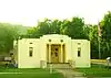 Marion Post No. 62 |
November 22, 2016 (#16000789) |
300 Elm Ave. 35°00′45″N 85°42′23″W |
South Pittsburg | Commonly called "American Legion Hall" |
| 9 | McKendree Methodist Episcopal Church |  McKendree Methodist Episcopal Church |
November 21, 1978 (#78002607) |
Betsy Pack Dr. 35°04′40″N 85°37′33″W |
Jasper | Built in 1875; now home to Faith Baptist Church |
| 10 | McNabb Mines | March 26, 2008 (#08000236) |
River Canyon Rd. between miles 438 and 439 on the Tennessee River 35°02′39″N 85°28′00″W |
Haletown | ||
| 11 | Nickajack Hydroelectric Project |  Nickajack Hydroelectric Project |
August 14, 2017 (#100001472) |
3490 TVA Rd. 35°00′15″N 85°37′10″W |
Haletown | |
| 12 | Primitive Baptist Church of Sweeten's Cove | June 30, 1983 (#83003050) |
Sweden Cove Rd. 35°04′15″N 85°46′48″W |
South Pittsburg | ||
| 13 | Putnam-Cumberland Historic District of Richard City | July 25, 1991 (#91000898) |
1805-1810 Cumberland and 1805-1812 Putnam Aves. 34°59′41″N 85°43′33″W |
South Pittsburg | ||
| 14 | RyeMabee |  RyeMabee |
December 22, 1997 (#97001565) |
224 E. Main St. 35°14′23″N 85°49′47″W |
Monteagle | |
| 15 | South Pittsburg Historic District | 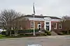 South Pittsburg Historic District |
October 25, 1990 (#90001573) |
Roughly bounded by Elm and Walnut Aves. and 2nd and 7th Sts.; also 700-804 Elm Ave. 35°00′42″N 85°42′37″W |
South Pittsburg | Second set of addresses represents a boundary increase of July 11, 2001 |
| 16 | Townsite Historic District of Richard City | July 25, 1991 (#91000897) |
402-512 Dixie, 102-106 Lee Hunt, and 2207 Cumberland Aves. 34°59′28″N 85°43′41″W |
South Pittsburg | ||
| 17 | Whitwell Cumberland Presbyterian Church | November 26, 2018 (#100003156) |
876 Main St. 35°12′02″N 85°31′12″W |
Whitwell |
Former listings
| [3] | Name on the Register | Image | Date listed | Date removed | Location | City or town | Summary |
|---|---|---|---|---|---|---|---|
| 1 | Cumberland Avenue Bridge | October 28, 1991 (#91001584) | July 13, 2001 | Cumberland Ave. over Poplar Springs Branch Creek |
South Pittsburg | ||
| 2 | Marion Memorial Bridge |  Marion Memorial Bridge |
September 6, 2007 (#07000930) | June 28, 2016 | U.S. Route 41 at Nickajack Lake 35°01′39″N 85°32′32″W |
Haletown |
See also
| Wikimedia Commons has media related to National Register of Historic Places in Marion County, Tennessee. |
References
- The latitude and longitude information provided in this table was derived originally from the National Register Information System, which has been found to be fairly accurate for about 99% of listings. Some locations in this table may have been corrected to current GPS standards.
- "National Register of Historic Places: Weekly List Actions". National Park Service, United States Department of the Interior. Retrieved on January 29, 2021.
- Numbers represent an alphabetical ordering by significant words. Various colorings, defined here, differentiate National Historic Landmarks and historic districts from other NRHP buildings, structures, sites or objects.
- "National Register Information System". National Register of Historic Places. National Park Service. April 24, 2008.
- The eight-digit number below each date is the number assigned to each location in the National Register Information System database, which can be viewed by clicking the number.
| Topics | |
|---|---|
| Lists by state |
|
| Lists by insular areas | |
| Lists by associated state | |
| Other areas | |
| Related | |
| |
Municipalities and communities of Marion County, Tennessee, United States | ||
|---|---|---|
| Cities | Map of Tennessee highlighting Marion County | |
| Towns | ||
| Unincorporated communities | ||
| Footnotes | ‡This populated place also has portions in an adjacent county or counties | |
| ||
This article is issued from Wikipedia. The text is licensed under Creative Commons - Attribution - Sharealike. Additional terms may apply for the media files.