National Register of Historic Places listings in Tipton County, Tennessee
This is a list of the National Register of Historic Places listings in Tipton County, Tennessee.
Location of Tipton County in Tennessee
This is intended to be a complete list of the properties and districts on the National Register of Historic Places in Tipton County, Tennessee, United States. Latitude and longitude coordinates are provided for many National Register properties and districts; these locations may be seen together in a map.[1]
There are 15 properties and districts listed on the National Register in the county.
| Anderson – Bedford – Benton – Bledsoe – Blount – Bradley – Campbell – Cannon – Carroll – Carter – Cheatham – Chester – Claiborne – Clay – Cocke – Coffee – Crockett – Cumberland – Davidson – Decatur – DeKalb – Dickson – Dyer – Fayette – Fentress – Franklin – Gibson – Giles – Grainger – Greene – Grundy – Hamblen – Hamilton – Hancock – Hardeman – Hardin – Hawkins – Haywood – Henderson – Henry – Hickman – Houston – Humphreys – Jackson – Jefferson – Johnson – Knox – Lake – Lauderdale – Lawrence – Lewis – Lincoln – Loudon – Macon – Madison – Marion – Marshall – Maury – McMinn – McNairy – Meigs – Monroe – Montgomery – Moore – Morgan – Obion – Overton – Perry – Pickett – Polk – Putnam – Rhea – Roane – Robertson – Rutherford – Scott – Sequatchie – Sevier – Shelby – Smith – Stewart – Sullivan – Sumner – Tipton – Trousdale – Unicoi – Union – Van Buren – Warren – Washington – Wayne – Weakley – White – Williamson – Wilson |
- This National Park Service list is complete through NPS recent listings posted February 5, 2021.[2]
Current listings
| [3] | Name on the Register[4] | Image | Date listed[5] | Location | City or town | Description |
|---|---|---|---|---|---|---|
| 1 | Bozo's Hot Pit Bar-B-Q | 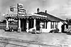 Bozo's Hot Pit Bar-B-Q |
March 27, 2018 (#100002264) |
342 US 70 35°24′37″N 89°32′23″W |
Mason | |
| 2 | Canaan Baptist Church | November 30, 1999 (#99001457) |
211 N. Main St. 35°33′34″N 89°38′20″W |
Covington | ||
| 3 | Charleston United Methodist Church and Cemetery | 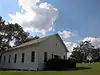 Charleston United Methodist Church and Cemetery |
July 17, 2002 (#02000811) |
Covington-Stanton Rd. 35°29′43″N 89°30′34″W |
Charleston | |
| 4 | Coca-Cola Bottling Plant |  Coca-Cola Bottling Plant |
February 7, 1997 (#97000038) |
126 U.S. Route 51, S. 35°33′51″N 89°38′58″W |
Covington | |
| 5 | Hotel Lindo | 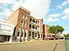 Hotel Lindo |
December 27, 1982 (#82001733) |
116 W. Liberty St. 35°33′52″N 89°38′48″W |
Covington | |
| 6 | Mt. Carmel Presbyterian Church | 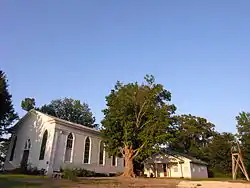 Mt. Carmel Presbyterian Church |
July 12, 1984 (#84003716) |
Mt. Carmel Rd. 35°29′49″N 89°38′53″W |
Covington | |
| 7 | Oak Hill Farm |  Oak Hill Farm |
March 27, 2013 (#13000125) |
1280 Keeling Rd. 35°27′21″N 89°31′06″W |
Stanton | |
| 8 | Old Trinity Episcopal Church | 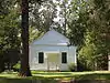 Old Trinity Episcopal Church |
May 21, 1997 (#97000039) |
Charleston Rd., 4 miles (6.4 km) northeast of Mason 35°27′21″N 89°31′06″W |
Mason | |
| 9 | Dr. Thomas H. Price House | June 13, 2016 (#15000118) |
620 N. Main St. 35°34′15″N 89°38′46″W |
Covington | ||
| 10 | Rhodes House | April 30, 1980 (#80003875) |
Southeast of Brighton on Clopton-Gainesville Rd. 35°26′51″N 89°38′28″W |
Brighton | ||
| 11 | Ruffin Theater |  Ruffin Theater |
March 26, 1992 (#92000248) |
113 W. Pleasant Ave. 35°33′43″N 89°38′50″W |
Covington | |
| 12 | St. Matthew's Episcopal Church |  St. Matthew's Episcopal Church |
August 16, 1977 (#77001297) |
Munford St. 35°33′45″N 89°38′25″W |
Covington | |
| 13 | South College Street Historic District | February 7, 1997 (#97000037) |
600, 700, and 800 blocks of S. College St. 35°33′45″N 89°38′55″W |
Covington | ||
| 14 | South Main Street Historic District | May 29, 1992 (#92000427) |
Roughly bounded by S. Main St., Sherrod Ave., S. Maple St., and Sanford and Lauderdale Aves. 35°33′35″N 89°38′44″W |
Covington | ||
| 15 | Trinity Church | 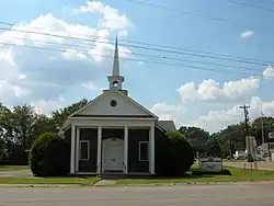 Trinity Church |
March 15, 1984 (#84003719) |
Main St. 35°24′45″N 89°32′04″W |
Mason |
See also
| Wikimedia Commons has media related to National Register of Historic Places in Tipton County, Tennessee. |
References
- The latitude and longitude information provided in this table was derived originally from the National Register Information System, which has been found to be fairly accurate for about 99% of listings. Some locations in this table may have been corrected to current GPS standards.
- "National Register of Historic Places: Weekly List Actions". National Park Service, United States Department of the Interior. Retrieved on February 5, 2021.
- Numbers represent an alphabetical ordering by significant words. Various colorings, defined here, differentiate National Historic Landmarks and historic districts from other NRHP buildings, structures, sites or objects.
- "National Register Information System". National Register of Historic Places. National Park Service. April 24, 2008.
- The eight-digit number below each date is the number assigned to each location in the National Register Information System database, which can be viewed by clicking the number.
Municipalities and communities of Tipton County, Tennessee, United States | ||
|---|---|---|
| Cities | Tipton County map | |
| Towns | ||
| Unincorporated communities | ||
| ||
| Topics | |
|---|---|
| Lists by state |
|
| Lists by insular areas | |
| Lists by associated state | |
| Other areas | |
| Related | |
| |
This article is issued from Wikipedia. The text is licensed under Creative Commons - Attribution - Sharealike. Additional terms may apply for the media files.