National Register of Historic Places listings in Obion County, Tennessee
This is a list of the National Register of Historic Places listings in Obion County, Tennessee.
Location of Obion County in Tennessee
This is intended to be a complete list of the properties and districts on the National Register of Historic Places in Obion County, Tennessee, United States. Latitude and longitude coordinates are provided for many National Register properties and districts; these locations may be seen together in a map.[1]
There are 16 properties and districts listed on the National Register in the county. Another 4 properties were once listed but have been removed.
| Anderson – Bedford – Benton – Bledsoe – Blount – Bradley – Campbell – Cannon – Carroll – Carter – Cheatham – Chester – Claiborne – Clay – Cocke – Coffee – Crockett – Cumberland – Davidson – Decatur – DeKalb – Dickson – Dyer – Fayette – Fentress – Franklin – Gibson – Giles – Grainger – Greene – Grundy – Hamblen – Hamilton – Hancock – Hardeman – Hardin – Hawkins – Haywood – Henderson – Henry – Hickman – Houston – Humphreys – Jackson – Jefferson – Johnson – Knox – Lake – Lauderdale – Lawrence – Lewis – Lincoln – Loudon – Macon – Madison – Marion – Marshall – Maury – McMinn – McNairy – Meigs – Monroe – Montgomery – Moore – Morgan – Obion – Overton – Perry – Pickett – Polk – Putnam – Rhea – Roane – Robertson – Rutherford – Scott – Sequatchie – Sevier – Shelby – Smith – Stewart – Sullivan – Sumner – Tipton – Trousdale – Unicoi – Union – Van Buren – Warren – Washington – Wayne – Weakley – White – Williamson – Wilson |
- This National Park Service list is complete through NPS recent listings posted January 29, 2021.[2]
Current listings
| [3] | Name on the Register[4] | Image | Date listed[5] | Location | City or town | Description |
|---|---|---|---|---|---|---|
| 1 | Thomas Leroy Bransford House | August 4, 1995 (#95000977) |
815 N. Ury St. 36°25′56″N 89°03′07″W |
Union City | ||
| 2 | Caldwell Lustron House | 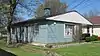 Caldwell Lustron House |
June 25, 1999 (#99000718) |
1020 E. Church St. 36°25′25″N 89°02′43″W |
Union City | |
| 3 | Capitol Theatre | 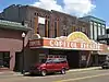 Capitol Theatre |
March 18, 1999 (#99000363) |
118 S. 1st St. 36°25′30″N 89°03′25″W |
Union City | |
| 4 | Confederate Monument | 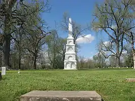 Confederate Monument |
July 28, 1977 (#77001286) |
Summer and Edwards Sts. 36°25′16″N 89°02′51″W |
Union City | |
| 5 | Deering Building | 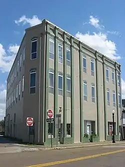 Deering Building |
November 25, 1983 (#83004283) |
106 1st St. 36°25′31″N 89°03′25″W |
Union City | |
| 6 | East Main Street and Exchange Street Historic District |  East Main Street and Exchange Street Historic District |
November 22, 1999 (#99001394) |
Roughly along Main, Exchange, and Church Sts. 36°25′30″N 89°02′58″W |
Union City | |
| 7 | Houser House |  Houser House |
July 17, 2002 (#02000809) |
2221 Old Troy Rd. 36°25′04″N 89°05′12″W |
Union City | |
| 8 | W.W. Morris House | 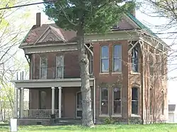 W.W. Morris House |
January 27, 1983 (#83003058) |
305 W. State Line Rd. 36°29′59″N 88°53′09″W |
South Fulton | |
| 9 | Mt. Zion Colored Methodist Episcopal Church | 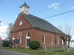 Mt. Zion Colored Methodist Episcopal Church |
February 16, 2001 (#01000140) |
Southeastern corner of the junction of College and Greenwood Sts. 36°25′42″N 89°02′40″W |
Union City | |
| 10 | Obion County Courthouse | 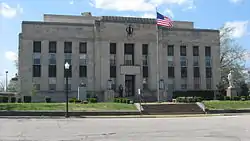 Obion County Courthouse |
March 30, 1995 (#95000340) |
Junction of 3rd and Washington Sts. 36°25′24″N 89°03′34″W |
Union City | |
| 11 | Railroad Park |  Railroad Park |
May 5, 1999 (#99000535) |
100 Park St. 36°25′26″N 89°03′23″W |
Union City | |
| 12 | Union City Armory | 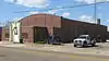 Union City Armory |
March 18, 1999 (#99000361) |
415 W. Main St. 36°25′34″N 89°03′38″W |
Union City | |
| 13 | Union City, Mobile and Ohio Railroad Depot | 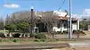 Union City, Mobile and Ohio Railroad Depot |
July 28, 1995 (#95000933) |
214 E. Church St. 36°25′28″N 89°03′20″W |
Union City | |
| 14 | US Post Office | 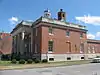 US Post Office |
May 31, 1984 (#84003671) |
114 W. Washington 36°25′22″N 89°03′29″W |
Union City | |
| 15 | Washington Avenue and Florida Avenue Historic District |  Washington Avenue and Florida Avenue Historic District |
September 1, 2001 (#01000955) |
Located along Washington And Florida Aves., between 3rd and 5th Sts. 36°25′24″N 89°03′37″W |
Union City | |
| 16 | Jesse Whitesell Farm | 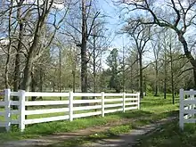 Jesse Whitesell Farm |
February 4, 2009 (#77000619) |
Southern side of Kentucky Route 116 west of the Purchase Parkway 36°30′05″N 88°54′04″W |
South Fulton | A boundary increase of the Jesse Whitesell House in Fulton County, Kentucky |
Former listing
| [3] | Name on the Register | Image | Date listed | Date removed | Location | City or town | Summary |
|---|---|---|---|---|---|---|---|
| 1 | Central Elementary School | 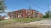 Central Elementary School |
February 16, 2001 (#01000141) | November 24, 2015 | 512 E. College St. 36°25′46″N 89°03′07″W |
Union City | |
| 2 | Colored Hotel | 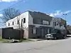 Colored Hotel |
August 11, 2008 (#08000284) | March 22, 2016 | 208 Nash St. 36°25′36″N 89°02′33″W |
Union City | |
| 3 | Dickey's Octagonal Barbershop | 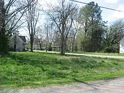 Dickey's Octagonal Barbershop |
April 29, 1975 (#75001772) | November 27, 2019 | Southwestern corner of the junction of High and N. Church Sts. 36°21′32″N 89°02′56″W |
Rives | |
| 4 | Parks Covered Bridge | November 27, 1978 (#78002624) | March 13, 1998 | North of Trimble off U.S. Route 51 |
Trimble |
See also
| Wikimedia Commons has media related to National Register of Historic Places in Obion County, Tennessee. |
References
- The latitude and longitude information provided in this table was derived originally from the National Register Information System, which has been found to be fairly accurate for about 99% of listings. Some locations in this table may have been corrected to current GPS standards.
- "National Register of Historic Places: Weekly List Actions". National Park Service, United States Department of the Interior. Retrieved on January 29, 2021.
- Numbers represent an alphabetical ordering by significant words. Various colorings, defined here, differentiate National Historic Landmarks and historic districts from other NRHP buildings, structures, sites or objects.
- "National Register Information System". National Register of Historic Places. National Park Service. April 24, 2008.
- The eight-digit number below each date is the number assigned to each location in the National Register Information System database, which can be viewed by clicking the number.
| Topics | |
|---|---|
| Lists by state |
|
| Lists by insular areas | |
| Lists by associated state | |
| Other areas | |
| Related | |
| |
Municipalities and communities of Obion County, Tennessee, United States | ||
|---|---|---|
| Cities | Obion County map | |
| Towns | ||
| Unincorporated communities | ||
| Footnotes | ‡This populated place also has portions in an adjacent county or counties | |
| ||
This article is issued from Wikipedia. The text is licensed under Creative Commons - Attribution - Sharealike. Additional terms may apply for the media files.