National Register of Historic Places listings in Hickman County, Tennessee
This is a list of the National Register of Historic Places listings in Hickman County, Tennessee.
Location of Hickman County in Tennessee
This is intended to be a complete list of the properties and districts on the National Register of Historic Places in Hickman County, Tennessee, United States. Latitude and longitude coordinates are provided for many National Register properties and districts; these locations may be seen together in a map.[1]
There are 11 properties and districts listed on the National Register in the county.
| Anderson – Bedford – Benton – Bledsoe – Blount – Bradley – Campbell – Cannon – Carroll – Carter – Cheatham – Chester – Claiborne – Clay – Cocke – Coffee – Crockett – Cumberland – Davidson – Decatur – DeKalb – Dickson – Dyer – Fayette – Fentress – Franklin – Gibson – Giles – Grainger – Greene – Grundy – Hamblen – Hamilton – Hancock – Hardeman – Hardin – Hawkins – Haywood – Henderson – Henry – Hickman – Houston – Humphreys – Jackson – Jefferson – Johnson – Knox – Lake – Lauderdale – Lawrence – Lewis – Lincoln – Loudon – Macon – Madison – Marion – Marshall – Maury – McMinn – McNairy – Meigs – Monroe – Montgomery – Moore – Morgan – Obion – Overton – Perry – Pickett – Polk – Putnam – Rhea – Roane – Robertson – Rutherford – Scott – Sequatchie – Sevier – Shelby – Smith – Stewart – Sullivan – Sumner – Tipton – Trousdale – Unicoi – Union – Van Buren – Warren – Washington – Wayne – Weakley – White – Williamson – Wilson |
- This National Park Service list is complete through NPS recent listings posted January 29, 2021.[2]
Current listings
| [3] | Name on the Register[4] | Image | Date listed[5] | Location | City or town | Description |
|---|---|---|---|---|---|---|
| 1 | Bon Aqua Springs Historic District | February 23, 1990 (#90000303) |
Old State Route 46, southeast of Bon Aqua 35°56′46″N 87°19′02″W |
Bon Aqua | ||
| 2 | John Gordon House | 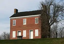 John Gordon House |
April 18, 1974 (#74000333) |
Northwest of Williamsport off State Route 50 35°43′11″N 87°15′38″W |
Williamsport | |
| 3 | Lee and Gould Furnace (40HI125) | April 9, 1988 (#88000248) |
Address Restricted |
Bucksnort | ||
| 4 | New Aetna Furnace Historic District (40HI149) | June 13, 1988 (#88000246) |
Address Restricted |
Aetna | ||
| 5 | Oakland Furnace and Forge (40HI146) | April 9, 1988 (#88000261) |
Address Restricted |
Texas Hollow | ||
| 6 | Old Aetna Furnace (40HI148) | April 9, 1988 (#88000247) |
Address Restricted |
Aetna | ||
| 7 | Old Natchez Trace | May 30, 1975 (#75002125) |
From the Alabama/Tennessee border to U.S. Route 100 in Davidson County Coordinates missing |
Chapel Hill | Extends into Davidson, Lawrence, Lewis, Maury, Wayne, and Williamson counties | |
| 8 | Primm Springs Historic District | July 5, 1985 (#85001480) |
Irregular pattern along the Puppy Branch of Dog Creek between House and Baker Rds. and Mineral Springs 35°49′24″N 87°15′01″W |
Primm Springs | ||
| 9 | Shelby Bend Archeological District | February 1, 1990 (#89001760) |
Address Restricted |
Greenfield Bend | Extends into Maury County | |
| 10 | Standard Furnace (40HI145) | April 9, 1988 (#88000243) |
Address Restricted |
Nunnelly | ||
| 11 | James Buchanan Walker House | 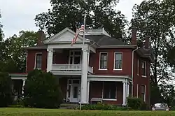 James Buchanan Walker House |
March 2, 1989 (#89000146) |
West End and S. Barnwell Aves. 35°46′44″N 87°28′13″W |
Centerville |
Former listings
One other property was once listed, but has since been removed:
| [3] | Name on the Register | Image | Date listed | Date removed | Location | City or town | Summary |
|---|---|---|---|---|---|---|---|
| 1 | Fairview School | December 8, 1983 (#83004252) | March 10, 2009 | 113 E. Hackberry St. 35°46′47″N 87°27′49″W |
Centerville | ||
| 2 | Pinewood | 1971 (#71001072) | 1975 | Pinewood Rd., Rt. #3 |
Nunnelly | Destroyed in 1975[6] |
See also
| Wikimedia Commons has media related to National Register of Historic Places in Hickman County, Tennessee. |
References
- The latitude and longitude information provided in this table was derived originally from the National Register Information System, which has been found to be fairly accurate for about 99% of listings. Some locations in this table may have been corrected to current GPS standards.
- "National Register of Historic Places: Weekly List Actions". National Park Service, United States Department of the Interior. Retrieved on January 29, 2021.
- Numbers represent an alphabetical ordering by significant words. Various colorings, defined here, differentiate National Historic Landmarks and historic districts from other NRHP buildings, structures, sites or objects.
- "National Register Information System". National Register of Historic Places. National Park Service. April 24, 2008.
- The eight-digit number below each date is the number assigned to each location in the National Register Information System database, which can be viewed by clicking the number.
- "Restored 'Pinewood' destroyed". March 16, 1975. p. 1. Retrieved July 29, 2016 – via Newspapers.com.
| Topics | |
|---|---|
| Lists by state |
|
| Lists by insular areas | |
| Lists by associated state | |
| Other areas | |
| Related | |
| |
Municipalities and communities of Hickman County, Tennessee, United States | ||
|---|---|---|
| Town | Hickman County map | |
| CDPs | ||
| Unincorporated communities | ||
| ||
This article is issued from Wikipedia. The text is licensed under Creative Commons - Attribution - Sharealike. Additional terms may apply for the media files.