National Register of Historic Places listings in Roane County, Tennessee
This is a list of the National Register of Historic Places listings in Roane County, Tennessee.
Location of Roane County in Tennessee
This is intended to be a complete list of the properties and historic districts in Roane County, Tennessee, United States, that are listed on the National Register of Historic Places. Latitude and longitude coordinates are provided for many National Register properties and districts; these locations may be seen together in a map.[1]
There are 20 properties and districts listed on the National Register in the county, including one National Historic Landmark.
See also National Register of Historic Places listings in Anderson County, Tennessee for additional properties in Oak Ridge and Oliver Springs, cities that span the county line.
| Anderson – Bedford – Benton – Bledsoe – Blount – Bradley – Campbell – Cannon – Carroll – Carter – Cheatham – Chester – Claiborne – Clay – Cocke – Coffee – Crockett – Cumberland – Davidson – Decatur – DeKalb – Dickson – Dyer – Fayette – Fentress – Franklin – Gibson – Giles – Grainger – Greene – Grundy – Hamblen – Hamilton – Hancock – Hardeman – Hardin – Hawkins – Haywood – Henderson – Henry – Hickman – Houston – Humphreys – Jackson – Jefferson – Johnson – Knox – Lake – Lauderdale – Lawrence – Lewis – Lincoln – Loudon – Macon – Madison – Marion – Marshall – Maury – McMinn – McNairy – Meigs – Monroe – Montgomery – Moore – Morgan – Obion – Overton – Perry – Pickett – Polk – Putnam – Rhea – Roane – Robertson – Rutherford – Scott – Sequatchie – Sevier – Shelby – Smith – Stewart – Sullivan – Sumner – Tipton – Trousdale – Unicoi – Union – Van Buren – Warren – Washington – Wayne – Weakley – White – Williamson – Wilson |
- This National Park Service list is complete through NPS recent listings posted January 29, 2021.[2]
Current listings
| [3] | Name on the Register[4] | Image | Date listed[5] | Location | City or town | Description |
|---|---|---|---|---|---|---|
| 1 | Abston Garage | 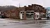 Abston Garage |
March 10, 2009 (#09000117) |
505 Winter Gap Ave. 36°02′39″N 84°20′39″W |
Oliver Springs | |
| 2 | Bethel Cemetery | 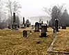 Bethel Cemetery |
June 26, 2006 (#06000547) |
Euclid Ave. and 3rd St. 35°52′16″N 84°31′02″W |
Kingston | |
| 3 | Colonial Hall | 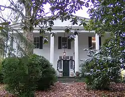 Colonial Hall |
September 11, 1975 (#75001774) |
Spring and Main Sts. 36°02′39″N 84°20′26″W |
Oliver Springs | Antebellum house currently being restored |
| 4 | Cornstalk Heights Historic District |  Cornstalk Heights Historic District |
January 11, 1991 (#90002142) |
Roughly bounded by Georgia Ave., Sewanee St., Morgan Ave., and Trenton St. 35°56′03″N 84°32′48″W |
Harriman | Contains several dozen contributing houses built in the 1890s through the 1930s |
| 5 | Harriman City Hall | 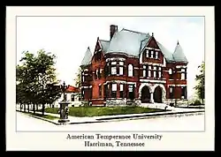 Harriman City Hall |
April 16, 1971 (#71000828) |
Roane and Walden Sts. 35°56′02″N 84°33′07″W |
Harriman | Building originally housed American Temperance University. |
| 6 | George Jones Memorial Baptist Church | 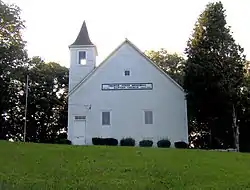 George Jones Memorial Baptist Church |
May 6, 1992 (#92000408) |
Blair Rd. 35°56′21″N 84°22′22″W |
Oak Ridge | |
| 7 | Kingston Avenue Historic District | 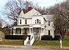 Kingston Avenue Historic District |
December 1, 1997 (#97001500) |
Roughly along N. Kingston, S. Kingston, and E. Rockwood Aves. 35°51′56″N 84°41′04″W |
Rockwood | |
| 8 | Molyneux Chevrolet Company-Rockwood Fire Department Building | 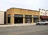 Molyneux Chevrolet Company-Rockwood Fire Department Building |
March 20, 2002 (#02000234) |
230 West Rockwood St. 35°52′07″N 84°41′14″W |
Rockwood | Building which was part fire station and part car dealership. |
| 9 | Col. Gideon Morgan House | 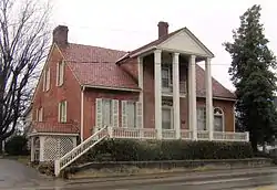 Col. Gideon Morgan House |
January 27, 1983 (#83003060) |
149 Kentucky St. 35°52′20″N 84°30′59″W |
Kingston | Oldest house in county. Bought in 1936 by William B. Ladd, Republican candidate for U.S. Senate in 1946 |
| 10 | New Bethel Baptist Church | 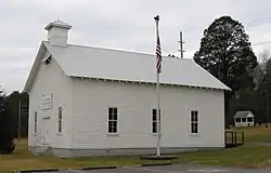 New Bethel Baptist Church |
May 6, 1992 (#92000409) |
Bethel Valley Rd. 35°56′01″N 84°18′19″W |
Oak Ridge | |
| 11 | Oak Ridge Turnpike Checking Station | 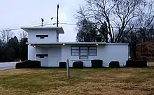 Oak Ridge Turnpike Checking Station |
May 6, 1992 (#92000412) |
Oak Ridge Turnpike 35°58′49″N 84°20′03″W |
Oak Ridge | One of three NRHP-listed World War II-era checkpoint gatehouses in Oak Ridge |
| 12 | Post Oak Springs Christian Church | 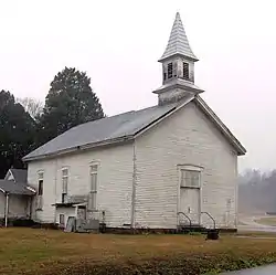 Post Oak Springs Christian Church |
March 15, 2007 (#07000156) |
Roane St. Highway (Old Kingston Highway) at Post Oak Rd. 35°52′25″N 84°38′02″W |
Rockwood | |
| 13 | Roane County Courthouse | 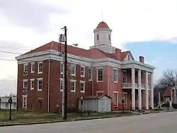 Roane County Courthouse |
July 14, 1971 (#71000829) |
Kentucky Ave. 35°52′18″N 84°30′57″W |
Kingston | Now a museum; the new courthouse is located across the street |
| 14 | Roane Street Commercial Historic District | 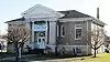 Roane Street Commercial Historic District |
June 29, 1989 (#89000506) |
Roughly Roane St. between Morgan Ave., NW. and Crescent Ave., NW. 35°56′04″N 84°33′01″W |
Harriman | Includes a theater, a Carnegie library, an old post office, and several storefronts along Roane Street |
| 15 | Rockwood Post Office | 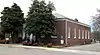 Rockwood Post Office |
December 30, 1999 (#99001621) |
340 W. Rockwood St.[6] 35°52′11″N 84°41′18″W |
Rockwood | |
| 16 | Southwest Point | Southwest Point |
July 31, 1972 (#72001252) |
1 mile southwest of Kingston 35°51′39″N 84°31′44″W |
Kingston | Fort no longer standing; currently being reconstructed |
| 17 | Dr. Fred Stone, Sr. Hospital |  Dr. Fred Stone, Sr. Hospital |
November 29, 2006 (#06001097) |
105 Roane St. 36°02′50″N 84°20′27″W |
Oliver Springs | Unique building constructed piecemeal in various phases, many of which can be discerned from the exterior brickwork |
| 18 | Tennessee Highway Patrol Buildings | 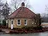 Tennessee Highway Patrol Buildings |
March 14, 2001 (#01000255) |
Junction of Kingston Ave. and Nelson St.; also Belson St. and U.S. Route 70 35°51′36″N 84°40′52″W |
Rockwood | Second address represents a boundary increase of March 15, 2011 |
| 19 | Valley View Farm | 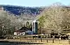 Valley View Farm |
March 21, 1997 (#97000257) |
160 Martin Rd. 35°54′09″N 84°36′29″W |
Harriman | mid-19th century farmstead |
| 20 | X-10 Reactor, Oak Ridge National Laboratory |  X-10 Reactor, Oak Ridge National Laboratory |
October 15, 1966 (#66000720) |
Oak Ridge National Laboratory 35°55′41″N 84°19′03″W |
Oak Ridge |
See also
| Wikimedia Commons has media related to National Register of Historic Places in Roane County, Tennessee. |
References
- The latitude and longitude information provided in this table was derived originally from the National Register Information System, which has been found to be fairly accurate for about 99% of listings. Some locations in this table may have been corrected to current GPS standards.
- "National Register of Historic Places: Weekly List Actions". National Park Service, United States Department of the Interior. Retrieved on January 29, 2021.
- Numbers represent an alphabetical ordering by significant words. Various colorings, defined here, differentiate National Historic Landmarks and historic districts from other NRHP buildings, structures, sites or objects.
- "National Register Information System". National Register of Historic Places. National Park Service. April 24, 2008.
- The eight-digit number below each date is the number assigned to each location in the National Register Information System database, which can be viewed by clicking the number.
- Address based on USPS website. Accessed April 10, 2016.
| Topics | |
|---|---|
| Lists by state |
|
| Lists by insular areas | |
| Lists by associated state | |
| Other areas | |
| Related | |
| |
Municipalities and communities of Roane County, Tennessee, United States | ||
|---|---|---|
| Cities | Roane County map | |
| Town | ||
| CDP | ||
| Unincorporated communities | ||
| Ghost towns/ neighborhoods | ||
| Footnotes | ‡This populated place also has portions in an adjacent county or counties | |
| ||
This article is issued from Wikipedia. The text is licensed under Creative Commons - Attribution - Sharealike. Additional terms may apply for the media files.