National Register of Historic Places listings in Haywood County, Tennessee
This is a list of the National Register of Historic Places listings in Haywood County, Tennessee.
Location of Haywood County in Tennessee
This is intended to be a complete list of the properties and districts on the National Register of Historic Places in Haywood County, Tennessee, United States. Latitude and longitude coordinates are provided for many National Register properties and districts; these locations may be seen together in a map.[1]
There are 14 properties and districts listed on the National Register in the county. One property was once listed, but has since been removed.
| Anderson – Bedford – Benton – Bledsoe – Blount – Bradley – Campbell – Cannon – Carroll – Carter – Cheatham – Chester – Claiborne – Clay – Cocke – Coffee – Crockett – Cumberland – Davidson – Decatur – DeKalb – Dickson – Dyer – Fayette – Fentress – Franklin – Gibson – Giles – Grainger – Greene – Grundy – Hamblen – Hamilton – Hancock – Hardeman – Hardin – Hawkins – Haywood – Henderson – Henry – Hickman – Houston – Humphreys – Jackson – Jefferson – Johnson – Knox – Lake – Lauderdale – Lawrence – Lewis – Lincoln – Loudon – Macon – Madison – Marion – Marshall – Maury – McMinn – McNairy – Meigs – Monroe – Montgomery – Moore – Morgan – Obion – Overton – Perry – Pickett – Polk – Putnam – Rhea – Roane – Robertson – Rutherford – Scott – Sequatchie – Sevier – Shelby – Smith – Stewart – Sullivan – Sumner – Tipton – Trousdale – Unicoi – Union – Van Buren – Warren – Washington – Wayne – Weakley – White – Williamson – Wilson |
- This National Park Service list is complete through NPS recent listings posted January 29, 2021.[2]
Current listings
| [3] | Name on the Register[4] | Image | Date listed[5] | Location | City or town | Description |
|---|---|---|---|---|---|---|
| 1 | Brownsville Carnegie Library | July 26, 2018 (#100002752) |
121 W Main St. 35°35′38″N 89°15′49″W |
Brownsville | ||
| 2 | College Hill Historic District | September 11, 1980 (#80003834) |
U.S. Routes 70/79 and State Route 19; also roughly bounded by Haralson, Margin & Cherry Sts., N. Wilson Ave. 35°35′36″N 89°16′12″W |
Brownsville | Second set of addresses represents a boundary increase January 27, 2015 | |
| 3 | Dancyville United Methodist Church and Cemetery | March 13, 1991 (#91000224) |
Dancyville Methodist Church St. 35°24′19″N 89°17′43″W |
Dancyville | ||
| 4 | Dunbar-Carver Historic District | January 27, 2015 (#14001224) |
Along E. Jefferson St. & roughly bounded by Anderson Ave., E. Main St. & RR tracks 35°35′31″N 89°15′09″W |
Brownsville | ||
| 5 | Joshua K. Hutchison House | 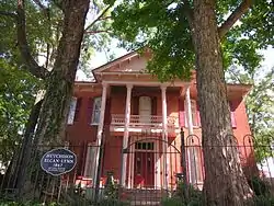 Joshua K. Hutchison House |
July 7, 1988 (#88001022) |
124 N. Church Ave. 35°35′44″N 89°15′31″W |
Brownsville | |
| 6 | Jefferson Street Historic District | March 28, 2016 (#14001225) |
Roughly bounded by Margin & E. Main Sts., S. Jackson & Washington Aves. 35°35′34″N 89°15′42″W |
Brownsville | ||
| 7 | North Washington Historic District | January 27, 2015 (#14000448) |
Roughly bounded by N. Wilson & N. Park Aves., Thomas & E. Main Sts. 35°35′44″N 89°15′37″W |
Brownsville | ||
| 8 | Republican Primitive Baptist Church | July 5, 2000 (#00000769) |
350 Raymond Taylor Rd. 35°38′01″N 89°25′55″W |
Brownsville | ||
| 9 | Stanton Masonic Lodge and School | October 22, 1987 (#87001878) |
W. Main St. 35°27′56″N 89°24′17″W |
Stanton | ||
| 10 | Stanton School | March 27, 2020 (#100005144) |
5 Lafayette St. 35°27′46″N 89°24′17″W |
Stanton | ||
| 11 | Temple Adas Israel | 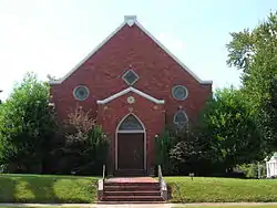 Temple Adas Israel |
January 19, 1979 (#79002445) |
Washington and College Sts. 35°35′44″N 89°15′45″W |
Brownsville | |
| 12 | Woodland Baptist Church | March 26, 2003 (#03000150) |
885 Woodland Church Rd. 35°33′51″N 89°06′02″W |
Woodland | ||
| 13 | Woodlawn Baptist Church and Cemetery | 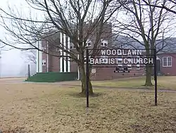 Woodlawn Baptist Church and Cemetery |
December 2, 1996 (#96001358) |
Woodlawn Rd., east of State Route 19 35°39′16″N 89°19′16″W |
Nutbush | |
| 14 | Zion Church | 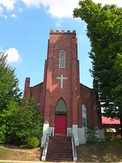 Zion Church |
November 21, 1978 (#78002601) |
College and Washington Sts. 35°35′44″N 89°15′42″W |
Brownsville |
Former listings
| [3] | Name on the Register | Image | Date listed | Date removed | Location | City or town | Summary |
|---|---|---|---|---|---|---|---|
| 1 | Cedar Grove | April 29, 1980 (#80003833) | July 25, 2018 | West of Brownsville 35°40′19″N 89°23′38″W |
Brownsville |
See also
| Wikimedia Commons has media related to National Register of Historic Places in Haywood County, Tennessee. |
References
- The latitude and longitude information provided in this table was derived originally from the National Register Information System, which has been found to be fairly accurate for about 99% of listings. Some locations in this table may have been corrected to current GPS standards.
- "National Register of Historic Places: Weekly List Actions". National Park Service, United States Department of the Interior. Retrieved on January 29, 2021.
- Numbers represent an alphabetical ordering by significant words. Various colorings, defined here, differentiate National Historic Landmarks and historic districts from other NRHP buildings, structures, sites or objects.
- "National Register Information System". National Register of Historic Places. National Park Service. April 24, 2008.
- The eight-digit number below each date is the number assigned to each location in the National Register Information System database, which can be viewed by clicking the number.
| Topics | |
|---|---|
| Lists by state |
|
| Lists by insular areas | |
| Lists by associated state | |
| Other areas | |
| Related | |
| |
Municipalities and communities of Haywood County, Tennessee, United States | ||
|---|---|---|
| City | Haywood County map | |
| Town | ||
| Unincorporated communities | ||
| ||
This article is issued from Wikipedia. The text is licensed under Creative Commons - Attribution - Sharealike. Additional terms may apply for the media files.