National Register of Historic Places listings in Smith County, Tennessee
This is a list of the National Register of Historic Places listings in Smith County, Tennessee.
Location of Smith County in Tennessee
This is intended to be a complete list of the properties and districts on the National Register of Historic Places in Smith County, Tennessee, United States. Latitude and longitude coordinates are provided for many National Register properties and districts; these locations may be seen together in a map.[1]
There are 13 properties and districts listed on the National Register in the county.
| Anderson – Bedford – Benton – Bledsoe – Blount – Bradley – Campbell – Cannon – Carroll – Carter – Cheatham – Chester – Claiborne – Clay – Cocke – Coffee – Crockett – Cumberland – Davidson – Decatur – DeKalb – Dickson – Dyer – Fayette – Fentress – Franklin – Gibson – Giles – Grainger – Greene – Grundy – Hamblen – Hamilton – Hancock – Hardeman – Hardin – Hawkins – Haywood – Henderson – Henry – Hickman – Houston – Humphreys – Jackson – Jefferson – Johnson – Knox – Lake – Lauderdale – Lawrence – Lewis – Lincoln – Loudon – Macon – Madison – Marion – Marshall – Maury – McMinn – McNairy – Meigs – Monroe – Montgomery – Moore – Morgan – Obion – Overton – Perry – Pickett – Polk – Putnam – Rhea – Roane – Robertson – Rutherford – Scott – Sequatchie – Sevier – Shelby – Smith – Stewart – Sullivan – Sumner – Tipton – Trousdale – Unicoi – Union – Van Buren – Warren – Washington – Wayne – Weakley – White – Williamson – Wilson |
- This National Park Service list is complete through NPS recent listings posted January 29, 2021.[2]
Current listings
| [3] | Name on the Register[4] | Image | Date listed[5] | Location | City or town | Description |
|---|---|---|---|---|---|---|
| 1 | Battery Knob Earthworks | Battery Knob Earthworks |
November 14, 2003 (#03001158) |
Approximately ½ mile north of Carthage[6] 36°16′05″N 85°56′55″W |
Carthage | Civil War-era Union artillery battery earthworks |
| 2 | James Bradley House | 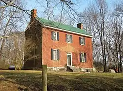 James Bradley House |
September 18, 1978 (#78002637) |
Southeast of Dixon Springs off State Route 25 36°20′36″N 86°02′35″W |
Dixon Springs | Still retains most of its original exterior |
| 3 | Carthage United Methodist Church |  Carthage United Methodist Church |
July 5, 1985 (#85001487) |
609 S. Main St. 36°15′19″N 85°57′04″W |
Carthage | Gothic Revival structure built in 1889; congregation established in 1808 |
| 4 | Cullum Mansion |  Cullum Mansion |
January 4, 1983 (#83003068) |
609 Cullum St. 36°15′19″N 85°56′51″W |
Carthage | Greek Revival-style antebellum mansion |
| 5 | Davis-Hull House |  Davis-Hull House |
January 4, 1983 (#83003069) |
1004 N. Main St. 36°15′35″N 85°57′06″W |
Carthage | Victorian-style house that once belonged to William Hull, father of Secretary of State Cordell Hull |
| 6 | Dixon Springs District |  Dixon Springs District |
February 10, 1975 (#75001788) |
1.75 miles northeast of the Cumberland River 36°21′32″N 86°03′09″W |
Dixon Springs | |
| 7 | Dixona |  Dixona |
July 5, 1973 (#73001832) |
Northwest of Dixon Springs on State Route 25 36°21′44″N 86°03′34″W |
Dixon Springs | Originally a log structure; wings and decks have been added over the years |
| 8 | Fite-Williams-Ligon House | 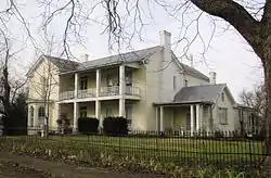 Fite-Williams-Ligon House |
July 17, 2003 (#03000663) |
212 Fite Ave., W. 36°15′15″N 85°57′13″W |
Carthage | |
| 9 | Fortified Town at the Mouth of Dixon Creek-Beasley Mounds | July 16, 2010 (#10000465) |
Triangle at the point of the confluence of Dixon Creek and the Cumberland River[7] 36°20′33″N 86°04′37″W |
Dixon Springs | Mississippian Cultural Resources of the Central Basin (AD 900–1450) MPS | |
| 10 | Cordell Hull Bridge |  Cordell Hull Bridge |
November 20, 2009 (#09000951) |
Cordell Hull Bridge St. over the Cumberland River 36°14′55″N 85°57′17″W |
Carthage | Parker Truss bridge built in 1936 |
| 11 | Moss Mounds | June 5, 2015 (#15000332) |
Address Restricted |
Elmwood vicinity | ||
| 12 | Rome Ferry |  Rome Ferry |
December 24, 1986 (#86003477) |
U.S. Route 70 at the Cumberland River 36°15′50″N 86°04′15″W |
Rome | The ruins of an early twentieth-century ferry tug |
| 13 | Smith County Courthouse |  Smith County Courthouse |
April 17, 1979 (#79002483) |
Court Sq. 36°15′06″N 85°57′09″W |
Carthage |
See also
| Wikimedia Commons has media related to National Register of Historic Places in Smith County, Tennessee. |
References
- The latitude and longitude information provided in this table was derived originally from the National Register Information System, which has been found to be fairly accurate for about 99% of listings. Some locations in this table may have been corrected to current GPS standards.
- "National Register of Historic Places: Weekly List Actions". National Park Service, United States Department of the Interior. Retrieved on January 29, 2021.
- Numbers represent an alphabetical ordering by significant words. Various colorings, defined here, differentiate National Historic Landmarks and historic districts from other NRHP buildings, structures, sites or objects.
- "National Register Information System". National Register of Historic Places. National Park Service. April 24, 2008.
- The eight-digit number below each date is the number assigned to each location in the National Register Information System database, which can be viewed by clicking the number.
- Location derived from its name and coordinates; the NRIS lists it as "Address Restricted" but provides the coordinates
- Location derived from Smith, Kevin E., and James V. Miller. Speaking with the Ancestors: Mississippian Stone Statuary of the Tennessee-Cumberland Region. Tuscaloosa: U of Alabama P, 2009, 53/54. The NRIS lists the site as "Address Restricted".
| Topics | |
|---|---|
| Lists by state |
|
| Lists by insular areas | |
| Lists by associated state | |
| Other areas | |
| Related | |
| |
Municipalities and communities of Smith County, Tennessee, United States | ||
|---|---|---|
| Towns | ||
| Unincorporated communities | ||
| ||
This article is issued from Wikipedia. The text is licensed under Creative Commons - Attribution - Sharealike. Additional terms may apply for the media files.