National Register of Historic Places listings in Polk County, Tennessee
This is a list of the National Register of Historic Places listings in Polk County, Tennessee.
Location of Polk County in Tennessee
This is intended to be a complete list of the properties and districts on the National Register of Historic Places in Polk County, Tennessee, United States. Latitude and longitude coordinates are provided for many National Register properties and districts; these locations may be seen together in a map.[1]
There are 18 properties and districts listed on the National Register in the county.
| Anderson – Bedford – Benton – Bledsoe – Blount – Bradley – Campbell – Cannon – Carroll – Carter – Cheatham – Chester – Claiborne – Clay – Cocke – Coffee – Crockett – Cumberland – Davidson – Decatur – DeKalb – Dickson – Dyer – Fayette – Fentress – Franklin – Gibson – Giles – Grainger – Greene – Grundy – Hamblen – Hamilton – Hancock – Hardeman – Hardin – Hawkins – Haywood – Henderson – Henry – Hickman – Houston – Humphreys – Jackson – Jefferson – Johnson – Knox – Lake – Lauderdale – Lawrence – Lewis – Lincoln – Loudon – Macon – Madison – Marion – Marshall – Maury – McMinn – McNairy – Meigs – Monroe – Montgomery – Moore – Morgan – Obion – Overton – Perry – Pickett – Polk – Putnam – Rhea – Roane – Robertson – Rutherford – Scott – Sequatchie – Sevier – Shelby – Smith – Stewart – Sullivan – Sumner – Tipton – Trousdale – Unicoi – Union – Van Buren – Warren – Washington – Wayne – Weakley – White – Williamson – Wilson |
- This National Park Service list is complete through NPS recent listings posted January 29, 2021.[2]
Current listings
| [3] | Name on the Register[4] | Image | Date listed[5] | Location | City or town | Description |
|---|---|---|---|---|---|---|
| 1 | Burra Burra Mine Historic District |  Burra Burra Mine Historic District |
March 17, 1983 (#83003059) |
State Route 68 and Burra St. 35°02′07″N 84°22′46″W |
Ducktown | |
| 2 | Buzzard's Roost Historic District | May 15, 1992 (#92000451) |
301-400 College, 420-430 Ell and 129-186 Main Sts., 400-415 School House Rd., and 211 and 215 State Route 68 35°01′59″N 84°23′04″W |
Ducktown | ||
| 3 | Center & Abernathy Store Building | September 2, 1992 (#92001071) |
23-33 Ocoee St. 34°59′18″N 84°22′16″W |
Copperhill | ||
| 4 | Central Headframe | September 2, 1992 (#92001073) |
State Route 68 south of its junction with U.S. Routes 64/74 35°01′16″N 84°22′55″W |
Ducktown | ||
| 5 | Copeland House |  Copeland House |
April 5, 1984 (#84003674) |
Cookson Creek Rd. 35°05′04″N 84°40′10″W |
Parksville | |
| 6 | Copperhill Historic District | May 15, 1992 (#92000449) |
Roughly bounded by Hill, Prospect, Main, and Riverview Sts. Boundary increase (listed July 16, 2008, refnum 08000688): Roughly bounded by Depaul St., Depot St., and Main St. 34°59′22″N 84°22′10″W |
Copperhill | ||
| 7 | Ducktown Historic District | 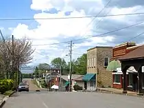 Ducktown Historic District |
May 15, 1992 (#92000450) |
Roughly bounded by State Route 68 and an alley 2 blocks northwest of Main St. 35°02′13″N 84°22′55″W |
Ducktown | |
| 8 | Isabella Managers' Row | May 15, 1992 (#92000448) |
Ducktown-Isabella Rd. north of U.S. Route 64 35°01′28″N 84°21′37″W |
Isabella | ||
| 9 | Kimsey Junior College |  Kimsey Junior College |
September 2, 1992 (#92001072) |
244 State Route 68 35°03′02″N 84°23′20″W |
Ducktown | |
| 10 | Knoxville Southern Railroad Historic District | 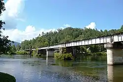 Knoxville Southern Railroad Historic District |
March 21, 2007 (#07000187) |
Former Knoxville Southern railroad line from near Reliance to near Farner 35°10′29″N 84°23′53″W |
Reliance | |
| 11 | Newtown Historic District | May 15, 1992 (#92000452) |
510-521 1st, 538-730 2nd, and 580-730 3rd Sts. 34°59′36″N 84°22′15″W |
Copperhill | ||
| 12 | Ocoee No. 1 Hydroelectric Station | 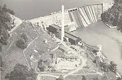 Ocoee No. 1 Hydroelectric Station |
July 5, 1990 (#90001003) |
Junction of U.S. Route 64 and the Ocoee River 35°05′40″N 84°38′52″W |
Parksville | |
| 13 | Ocoee Hydroelectric Plant No. 2 | Ocoee Hydroelectric Plant No. 2 |
October 31, 1979 (#79002453) |
U.S. Route 64 35°04′58″N 84°29′28″W |
Ocoee | |
| 14 | Ocoee No. 3 Hydroelectric Project | 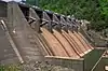 Ocoee No. 3 Hydroelectric Project |
August 14, 2017 (#100001473) |
1988 US 64 35°02′26″N 84°28′00″W |
Benton | |
| 15 | Polk County Courthouse |  Polk County Courthouse |
June 24, 1993 (#93000562) |
Bounded by U.S. Route 411 and Ward, Commerce, and Main Sts. 35°10′24″N 84°39′12″W |
Benton | |
| 16 | Reliance Historic District | March 13, 1986 (#86000350) |
Roughly bounded by New Reliance and Power House Rds., State Route 30, and the Hiwassee River 35°11′23″N 84°30′08″W |
Reliance | ||
| 17 | Nancy Ward Tomb | 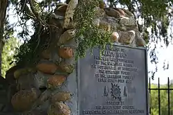 Nancy Ward Tomb |
April 11, 1973 (#73001815) |
South of Benton on U.S. Route 411 35°09′51″N 84°40′50″W |
Benton | |
| 18 | William Wiggins House | 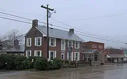 William Wiggins House |
December 2, 1993 (#93001355) |
Northeastern corner of the junction of Main and Ward Sts. 35°10′26″N 84°39′12″W |
Benton |
See also
| Wikimedia Commons has media related to National Register of Historic Places in Polk County, Tennessee. |
References
- The latitude and longitude information provided in this table was derived originally from the National Register Information System, which has been found to be fairly accurate for about 99% of listings. Some locations in this table may have been corrected to current GPS standards.
- "National Register of Historic Places: Weekly List Actions". National Park Service, United States Department of the Interior. Retrieved on January 29, 2021.
- Numbers represent an alphabetical ordering by significant words. Various colorings, defined here, differentiate National Historic Landmarks and historic districts from other NRHP buildings, structures, sites or objects.
- "National Register Information System". National Register of Historic Places. National Park Service. April 24, 2008.
- The eight-digit number below each date is the number assigned to each location in the National Register Information System database, which can be viewed by clicking the number.
| Topics | |
|---|---|
| Lists by state |
|
| Lists by insular areas | |
| Lists by associated state | |
| Other areas | |
| Related | |
| |
Municipalities and communities of Polk County, Tennessee, United States | ||
|---|---|---|
| Cities | ||
| Town | ||
| Unincorporated communities | ||
| ||
This article is issued from Wikipedia. The text is licensed under Creative Commons - Attribution - Sharealike. Additional terms may apply for the media files.