National Register of Historic Places listings in Cocke County, Tennessee
This is a list of the National Register of Historic Places listings in Cocke County, Tennessee.
Location of Cocke County in Tennessee
This is intended to be a complete list of the properties and districts on the National Register of Historic Places in Cocke County, Tennessee, United States. Latitude and longitude coordinates are provided for many National Register properties and districts; these locations may be seen together in a map.[1]
There are 15 properties and districts listed on the National Register in the county.
| Anderson – Bedford – Benton – Bledsoe – Blount – Bradley – Campbell – Cannon – Carroll – Carter – Cheatham – Chester – Claiborne – Clay – Cocke – Coffee – Crockett – Cumberland – Davidson – Decatur – DeKalb – Dickson – Dyer – Fayette – Fentress – Franklin – Gibson – Giles – Grainger – Greene – Grundy – Hamblen – Hamilton – Hancock – Hardeman – Hardin – Hawkins – Haywood – Henderson – Henry – Hickman – Houston – Humphreys – Jackson – Jefferson – Johnson – Knox – Lake – Lauderdale – Lawrence – Lewis – Lincoln – Loudon – Macon – Madison – Marion – Marshall – Maury – McMinn – McNairy – Meigs – Monroe – Montgomery – Moore – Morgan – Obion – Overton – Perry – Pickett – Polk – Putnam – Rhea – Roane – Robertson – Rutherford – Scott – Sequatchie – Sevier – Shelby – Smith – Stewart – Sullivan – Sumner – Tipton – Trousdale – Unicoi – Union – Van Buren – Warren – Washington – Wayne – Weakley – White – Williamson – Wilson |
- This National Park Service list is complete through NPS recent listings posted January 29, 2021.[2]
Current listings
| [3] | Name on the Register[4] | Image | Date listed[5] | Location | City or town | Description |
|---|---|---|---|---|---|---|
| 1 | Beechwood Hall | May 29, 1975 (#75001741) |
North of Newport on Rankin Rd. 35°59′27″N 83°10′59″W |
Newport | ||
| 2 | Cocke County Courthouse | 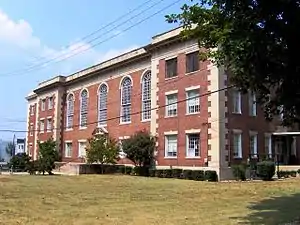 Cocke County Courthouse |
May 4, 1995 (#95000538) |
111 Court Ave. 35°58′00″N 83°11′05″W |
Newport | |
| 3 | Cocke County Memorial Building |  Cocke County Memorial Building |
September 11, 1997 (#97001139) |
103 N. Cosby Highway 35°58′03″N 83°11′36″W |
Newport | |
| 4 | Conway Bridge |  Conway Bridge |
November 20, 2009 (#09000948) |
Briar Thicket Rd./Knob Creek Rd. over the Nolichucky River 36°07′21″N 83°07′31″W |
Briar Thicket | Extends into Greene County[4] |
| 5 | Walter C. Cureton House | 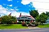 Walter C. Cureton House |
November 29, 2001 (#01001325) |
202 Lincoln Ave. 35°57′44″N 83°10′44″W |
Newport | |
| 6 | Elm Hill | 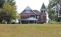 Elm Hill |
May 29, 1975 (#75001742) |
206 W. Riverview St. 35°57′56″N 83°11′27″W |
Newport | |
| 7 | English Mountain Fire Lookout Tower | November 20, 2015 (#15000832) |
Carson Springs Rd. 35°54′21″N 83°17′46″W |
Chestnut Hill | ||
| 8 | Leadvale Coaling Station and Cut-off | 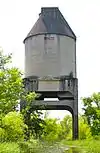 Leadvale Coaling Station and Cut-off |
December 1, 2014 (#14000997) |
Rankin Bottoms Wildlife Management Area[6] 36°04′45″N 83°14′24″W |
Newport | Locally known as the "Rankin Coal Tipple";[7] includes two miles of abandoned Southern Railway lines, together with a bridge abutment and coal tipple[6] |
| 9 | Mount Cammerer Fire Lookout |  Mount Cammerer Fire Lookout |
June 12, 2019 (#100004091) |
Great Smoky Mountains National Park (GRSM) - end of Mount Cammerer 35°45′49″N 83°09′41″W |
Cosby | |
| 10 | Neas Farm | 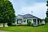 Neas Farm |
March 10, 2004 (#04000152) |
3301 Sable Rd. 36°01′56″N 83°00′46″W |
Parrottsville | |
| 11 | O'Dell House | 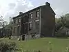 O'Dell House |
April 1, 1975 (#75001744) |
Northeast of Newport on the Greeneville Highway 35°58′55″N 83°09′46″W |
Newport | |
| 12 | Rhea-Mims Hotel | 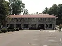 Rhea-Mims Hotel |
July 1, 1998 (#98000822) |
335 East Broadway 35°57′57″N 83°11′01″W |
Newport | |
| 13 | Swaggerty Blockhouse | 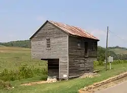 Swaggerty Blockhouse |
June 18, 1973 (#73001756) |
East of Parrottsville on Old Parrottsville Highway 36°00′47″N 83°04′17″W |
Parrottsville | |
| 14 | Vinson House | May 29, 1975 (#75001745) |
4.5 miles south of Newport off Hartford Rd. 35°53′21″N 83°11′06″W |
Newport | ||
| 15 | Yett-Ellison House | April 16, 1975 (#75001746) |
Main St. (Greeneville Highway) 36°00′29″N 83°05′19″W |
Parrottsville |
Former listings
| [3] | Name on the Register | Image | Date listed | Date removed | Location | City or town | Summary |
|---|---|---|---|---|---|---|---|
| 1 | Greenlawn | May 29, 1975 (#75001743) | December 13, 1999 | NW of Newport on Old Rankin Rd. |
Newport vicinity |
See also
| Wikimedia Commons has media related to National Register of Historic Places in Cocke County, Tennessee. |
References
- The latitude and longitude information provided in this table was derived originally from the National Register Information System, which has been found to be fairly accurate for about 99% of listings. Some locations in this table may have been corrected to current GPS standards.
- "National Register of Historic Places: Weekly List Actions". National Park Service, United States Department of the Interior. Retrieved on January 29, 2021.
- Numbers represent an alphabetical ordering by significant words. Various colorings, defined here, differentiate National Historic Landmarks and historic districts from other NRHP buildings, structures, sites or objects.
- "National Register Information System". National Register of Historic Places. National Park Service. April 24, 2008.
- The eight-digit number below each date is the number assigned to each location in the National Register Information System database, which can be viewed by clicking the number.
- Three Tennessee Sites Added to the National Register of Historic Places, Tennessee Historical Commission, 2015-01-05. Accessed 2016-02-28.
- Rankin Coal Tipple among nominees for National Register of Historic Places, Newport Plain Talk, 2014-09-05. Accessed 2016-05-05.
| Topics | |
|---|---|
| Lists by state |
|
| Lists by insular areas | |
| Lists by associated state | |
| Other areas | |
| Related | |
| |
Municipalities and communities of Cocke County, Tennessee, United States | ||
|---|---|---|
| City | ||
| Town | ||
| CDP | ||
| Unincorporated communities | ||
| Footnotes | ‡This populated place also portions in an adjacent county or counties | |
| ||
This article is issued from Wikipedia. The text is licensed under Creative Commons - Attribution - Sharealike. Additional terms may apply for the media files.