National Register of Historic Places listings in Gibson County, Tennessee
This is a list of the National Register of Historic Places listings in Gibson County, Tennessee.
Location of Gibson County in Tennessee
This is intended to be a complete list of the properties and districts on the National Register of Historic Places in Gibson County, Tennessee, United States. Latitude and longitude coordinates are provided for many National Register properties and districts; these locations may be seen together in a map.[1]
There are 20 properties and districts listed on the National Register in the county.
| Anderson – Bedford – Benton – Bledsoe – Blount – Bradley – Campbell – Cannon – Carroll – Carter – Cheatham – Chester – Claiborne – Clay – Cocke – Coffee – Crockett – Cumberland – Davidson – Decatur – DeKalb – Dickson – Dyer – Fayette – Fentress – Franklin – Gibson – Giles – Grainger – Greene – Grundy – Hamblen – Hamilton – Hancock – Hardeman – Hardin – Hawkins – Haywood – Henderson – Henry – Hickman – Houston – Humphreys – Jackson – Jefferson – Johnson – Knox – Lake – Lauderdale – Lawrence – Lewis – Lincoln – Loudon – Macon – Madison – Marion – Marshall – Maury – McMinn – McNairy – Meigs – Monroe – Montgomery – Moore – Morgan – Obion – Overton – Perry – Pickett – Polk – Putnam – Rhea – Roane – Robertson – Rutherford – Scott – Sequatchie – Sevier – Shelby – Smith – Stewart – Sullivan – Sumner – Tipton – Trousdale – Unicoi – Union – Van Buren – Warren – Washington – Wayne – Weakley – White – Williamson – Wilson |
- This National Park Service list is complete through NPS recent listings posted January 29, 2021.[2]
Current listings
| [3] | Name on the Register[4] | Image | Date listed[5] | Location | City or town | Description |
|---|---|---|---|---|---|---|
| 1 | Bonds House | August 30, 2010 (#10000473) |
204 S. 19th Ave. 35°49′06″N 88°54′35″W |
Humboldt | ||
| 2 | Booker T. Motel | July 25, 2018 (#100002750) |
607 W Main St. 35°49′12″N 88°55′20″W |
Humboldt | ||
| 3 | Browning House | June 28, 1974 (#74001912) |
East of Milan on the Milan Army Ammunition Plant 35°55′27″N 88°43′10″W |
Milan | ||
| 4 | Dodson House | 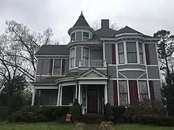 Dodson House |
March 25, 1982 (#82003969) |
119 N. 17th Ave. 35°49′14″N 88°54′47″W |
Humboldt | |
| 5 | First Methodist Episcopal Church, South | July 23, 2008 (#08000702) |
200 N. 12th Ave. 35°49′15″N 88°55′08″W |
Humboldt | ||
| 6 | Julius Freed House | 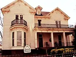 Julius Freed House |
April 5, 1994 (#94000301) |
Eaton St. west of the Gibson County Courthouse 35°58′49″N 88°56′18″W |
Trenton | |
| 7 | Gibson County Courthouse | 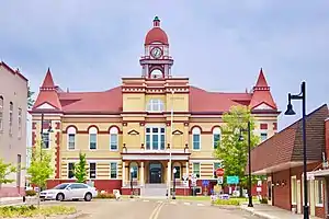 Gibson County Courthouse |
November 7, 1976 (#76001777) |
Court Sq. 35°58′51″N 88°56′29″W |
Trenton | Built in 1899 |
| 8 | Gibson County Training School | March 12, 2012 (#12000117) |
1041 S. Harris St. 35°58′51″N 88°56′29″W |
Milan | ||
| 9 | Medina City Hall | July 7, 2004 (#04000674) |
115 2nd St. 35°48′16″N 88°46′36″W |
Medina | ||
| 10 | Mt. Zion Negro School | November 13, 2017 (#100001823) |
30 Mt. Zion Rd. 36°05′43″N 88°53′13″W |
Bradford vicinity | ||
| 11 | Oakland Cemetery | March 20, 2007 (#07000186) |
800 Brownsville St. 35°58′17″N 88°56′40″W |
Trenton | ||
| 12 | Peabody High School | November 23, 1984 (#84000326) |
S. College St. 35°58′10″N 88°56′31″W |
Trenton | ||
| 13 | Senter-Rooks House |  Senter-Rooks House |
July 9, 1980 (#80003797) |
2227 Main St. 35°49′15″N 88°54′22″W |
Humboldt | |
| 14 | Sitka School | March 27, 2020 (#100005137) |
Napoleon Luther Rd. 35°51′48″N 88°45′37″W |
Milan | ||
| 15 | Skullbone Store | 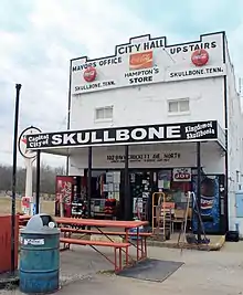 Skullbone Store |
November 18, 1999 (#99001369) |
1 Shade's Bridge Rd. 36°05′02″N 88°45′41″W |
Skullbone | |
| 16 | Col. Robert Z. Taylor House | April 12, 1982 (#82003970) |
1008 S. College St. 35°58′05″N 88°56′31″W |
Trenton | ||
| 17 | Trenton Historic District | April 15, 1982 (#82003971) |
High, College, and Church Sts. 35°58′34″N 88°56′30″W |
Trenton | ||
| 18 | Union Central School | July 5, 1985 (#85001490) |
Union Central Rd. 35°57′54″N 88°47′04″W |
Milan | ||
| 19 | US Post Office | July 9, 1987 (#87001169) |
382 S. Main St. 35°55′02″N 88°45′51″W |
Milan | ||
| 20 | US Post Office | 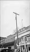 US Post Office |
September 23, 1988 (#88001576) |
200 S. College St. 35°58′55″N 88°56′30″W |
Trenton |
See also
| Wikimedia Commons has media related to National Register of Historic Places in Gibson County, Tennessee. |
References
- The latitude and longitude information provided in this table was derived originally from the National Register Information System, which has been found to be fairly accurate for about 99% of listings. Some locations in this table may have been corrected to current GPS standards.
- "National Register of Historic Places: Weekly List Actions". National Park Service, United States Department of the Interior. Retrieved on January 29, 2021.
- Numbers represent an alphabetical ordering by significant words. Various colorings, defined here, differentiate National Historic Landmarks and historic districts from other NRHP buildings, structures, sites or objects.
- "National Register Information System". National Register of Historic Places. National Park Service. April 24, 2008.
- The eight-digit number below each date is the number assigned to each location in the National Register Information System database, which can be viewed by clicking the number.
| Topics | |
|---|---|
| Lists by state |
|
| Lists by insular areas | |
| Lists by associated state | |
| Other areas | |
| Related | |
| |
Municipalities and communities of Gibson County, Tennessee, United States | ||
|---|---|---|
| Cities | Gibson County map | |
| Towns | ||
| Unincorporated communities | ||
| Footnotes | ‡This populated place also has portions in an adjacent county or counties | |
| ||
This article is issued from Wikipedia. The text is licensed under Creative Commons - Attribution - Sharealike. Additional terms may apply for the media files.