National Register of Historic Places listings in Lawrence County, Tennessee
This is a list of the National Register of Historic Places listings in Lawrence County, Tennessee.
Location of Lawrence County in Tennessee
This is intended to be a complete list of the properties and districts on the National Register of Historic Places in Lawrence County, Tennessee, United States. Latitude and longitude coordinates are provided for many National Register properties and districts; these locations may be seen together in a map.[1]
There are 15 properties and districts listed on the National Register in the county.
| Anderson – Bedford – Benton – Bledsoe – Blount – Bradley – Campbell – Cannon – Carroll – Carter – Cheatham – Chester – Claiborne – Clay – Cocke – Coffee – Crockett – Cumberland – Davidson – Decatur – DeKalb – Dickson – Dyer – Fayette – Fentress – Franklin – Gibson – Giles – Grainger – Greene – Grundy – Hamblen – Hamilton – Hancock – Hardeman – Hardin – Hawkins – Haywood – Henderson – Henry – Hickman – Houston – Humphreys – Jackson – Jefferson – Johnson – Knox – Lake – Lauderdale – Lawrence – Lewis – Lincoln – Loudon – Macon – Madison – Marion – Marshall – Maury – McMinn – McNairy – Meigs – Monroe – Montgomery – Moore – Morgan – Obion – Overton – Perry – Pickett – Polk – Putnam – Rhea – Roane – Robertson – Rutherford – Scott – Sequatchie – Sevier – Shelby – Smith – Stewart – Sullivan – Sumner – Tipton – Trousdale – Unicoi – Union – Van Buren – Warren – Washington – Wayne – Weakley – White – Williamson – Wilson |
- This National Park Service list is complete through NPS recent listings posted January 29, 2021.[2]
Current listings
| [3] | Name on the Register[4] | Image | Date listed[5] | Location | City or town | Description |
|---|---|---|---|---|---|---|
| 1 | Bank of Loretto | November 27, 2019 (#100004682) |
200 Broad St. 35°04′40″N 87°26′24″W |
Loretto | ||
| 2 | Crockett Theater | 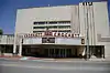 Crockett Theater |
July 29, 1997 (#97000804) |
205 N. Military Ave. 35°14′31″N 87°20′04″W |
Lawrenceburg | |
| 3 | Farmers and Merchants Bank | November 13, 2017 (#100001825) |
213 Depot St. 35°19′12″N 87°18′20″W |
Ethridge | ||
| 4 | Garrett House | .JPG.webp) Garrett House |
March 17, 2009 (#09000137) |
205 S. Military Ave. 35°14′22″N 87°20′09″W |
Lawrenceburg | |
| 5 | T.D. Davenport Forge (40LR7) | July 19, 1988 (#88001101) |
Address Restricted |
Lawrenceburg | ||
| 6 | Lawrence County Jail | 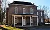 Lawrence County Jail |
March 16, 1976 (#76001784) |
Waterloo St. 35°14′28″N 87°20′15″W |
Lawrenceburg | |
| 7 | Lawrenceburg Commercial Historic District | 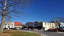 Lawrenceburg Commercial Historic District |
April 14, 1992 (#92000346) |
Roughly bounded by N. Military St., Public Sq., E. Gaines St., and E. Pulaski St. 35°14′29″N 87°20′04″W |
Lawrenceburg | |
| 8 | Lawrenceburg No. 1 Hydroelectric Station | April 20, 1990 (#90000308) |
Glen Spring Rd. at Horseshoe Bend of Little Shoal Creek 35°13′43″N 87°21′29″W |
Lawrenceburg | ||
| 9 | Lawrenceburg No. 2 Hydroelectric Station | July 5, 1990 (#90001005) |
Mile 51.7 on Shoal Creek near Old U.S. Route 43 35°12′55″N 87°21′47″W |
Lawrenceburg | ||
| 10 | Mount Zion Methodist Episcopal Church South | 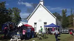 Mount Zion Methodist Episcopal Church South |
March 10, 1988 (#88000201) |
Mount Zion Rd. 35°03′55″N 87°13′57″W |
Fall River | |
| 11 | Old Natchez Trace |  Old Natchez Trace |
May 30, 1975 (#75002125) |
From the Alabama/Tennessee border to State Route 100 in Davidson County Coordinates missing |
N.A. | Extends into Davidson, Hickman, Lewis, Maury, Wayne, and Williamson counties |
| 12 | Sacred Heart of Jesus Church | .JPG.webp) Sacred Heart of Jesus Church |
October 10, 1984 (#84000093) |
Berger St. 35°14′46″N 87°20′07″W |
Lawrenceburg | |
| 13 | Sacred Heart of Jesus Church | 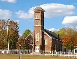 Sacred Heart of Jesus Church |
October 10, 1984 (#84000094) |
Church St. 35°04′36″N 87°26′36″W |
Loretto | Built in 1912 |
| 14 | St. Joseph Church | October 10, 1984 (#84000113) |
Spring St. 35°01′59″N 87°30′11″W |
St. Joseph | ||
| 15 | St. Mary's Cemetery | October 10, 1984 (#84000095) |
off Rascal Town Rd. 35°01′53″N 87°24′53″W |
Former listings
One other property was once listed, but has since been removed.
| [3] | Name on the Register | Image | Date listed | Date removed | Location | City or town | Summary |
|---|---|---|---|---|---|---|---|
| 1 | Garner Mill | July 12, 1984 (#84003575) | November 19, 2008 | Garner Lane |
Lawrenceburg | Destroyed by flooding in 1998 |
See also
| Wikimedia Commons has media related to National Register of Historic Places in Lawrence County, Tennessee. |
References
- The latitude and longitude information provided in this table was derived originally from the National Register Information System, which has been found to be fairly accurate for about 99% of listings. Some locations in this table may have been corrected to current GPS standards.
- "National Register of Historic Places: Weekly List Actions". National Park Service, United States Department of the Interior. Retrieved on January 29, 2021.
- Numbers represent an alphabetical ordering by significant words. Various colorings, defined here, differentiate National Historic Landmarks and historic districts from other NRHP buildings, structures, sites or objects.
- "National Register Information System". National Register of Historic Places. National Park Service. April 24, 2008.
- The eight-digit number below each date is the number assigned to each location in the National Register Information System database, which can be viewed by clicking the number.
| Topics | |
|---|---|
| Lists by state |
|
| Lists by insular areas | |
| Lists by associated state | |
| Other areas | |
| Related | |
| |
Municipalities and communities of Lawrence County, Tennessee, United States | ||
|---|---|---|
| Cities | Lawrence County map | |
| Town | ||
| CDP | ||
| Other unincorporated communities | ||
| Ghost town | ||
| ||
This article is issued from Wikipedia. The text is licensed under Creative Commons - Attribution - Sharealike. Additional terms may apply for the media files.