National Register of Historic Places listings in Grundy County, Tennessee
This is a list of the National Register of Historic Places listings in Grundy County, Tennessee.
Location of Grundy County in Tennessee
This is intended to be a complete list of the properties and districts on the National Register of Historic Places in Grundy County, Tennessee, United States. Latitude and longitude coordinates are provided for many National Register properties and districts; these locations may be seen together in a map.[1]
There are 22 properties and districts listed on the National Register in the county. Another 4 properties in the county were once listed, but have since been removed.
See also National Register of Historic Places listings in Marion County, Tennessee for additional properties in Monteagle, a city that spans the county line.
| Anderson – Bedford – Benton – Bledsoe – Blount – Bradley – Campbell – Cannon – Carroll – Carter – Cheatham – Chester – Claiborne – Clay – Cocke – Coffee – Crockett – Cumberland – Davidson – Decatur – DeKalb – Dickson – Dyer – Fayette – Fentress – Franklin – Gibson – Giles – Grainger – Greene – Grundy – Hamblen – Hamilton – Hancock – Hardeman – Hardin – Hawkins – Haywood – Henderson – Henry – Hickman – Houston – Humphreys – Jackson – Jefferson – Johnson – Knox – Lake – Lauderdale – Lawrence – Lewis – Lincoln – Loudon – Macon – Madison – Marion – Marshall – Maury – McMinn – McNairy – Meigs – Monroe – Montgomery – Moore – Morgan – Obion – Overton – Perry – Pickett – Polk – Putnam – Rhea – Roane – Robertson – Rutherford – Scott – Sequatchie – Sevier – Shelby – Smith – Stewart – Sullivan – Sumner – Tipton – Trousdale – Unicoi – Union – Van Buren – Warren – Washington – Wayne – Weakley – White – Williamson – Wilson |
- This National Park Service list is complete through NPS recent listings posted January 29, 2021.[2]
Current listings
| [3] | Name on the Register[4] | Image | Date listed[5] | Location | City or town | Description |
|---|---|---|---|---|---|---|
| 1 | Beersheba Springs Historic District | 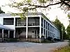 Beersheba Springs Historic District |
March 20, 1980 (#80003801) |
State Route 56 35°28′00″N 85°39′23″W |
Beersheba Springs | Includes the Beersheba Springs Hotel complex and more than two dozen other buildings associated with late-19th and early-20th century Beersheba Springs resort |
| 2 | Christ Episcopal Church | April 24, 2015 (#15000186) |
530 10th St. 35°15′28″N 85°44′09″W |
Tracy City | ||
| 3 | Coalmont Bank Building | 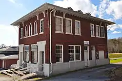 Coalmont Bank Building |
March 14, 1991 (#91000246) |
Junction of State Route 56 and Heidenburg St. 35°20′21″N 85°42′12″W |
Coalmont | |
| 4 | DuBose Memorial Church Training School | 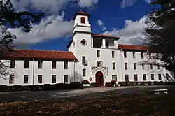 DuBose Memorial Church Training School |
November 25, 1980 (#80003802) |
Fairmont and College Sts. 35°14′29″N 85°49′38″W |
Monteagle | |
| 5 | Firescald Creek Stone Arch Bridge | 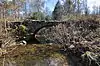 Firescald Creek Stone Arch Bridge |
April 1, 1987 (#87000522) |
Northcutts Cove Rd. over Firescald Creek 35°26′45″N 85°43′46″W |
Altamont | |
| 6 | Grundy Lakes Historic District | April 1, 1987 (#87000538) |
Grundy Lakes State Park east of State Route 56 35°16′11″N 85°43′00″W |
Tracy City | ||
| 7 | E.L. Hampton House | 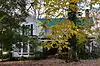 E.L. Hampton House |
April 1, 1987 (#87000528) |
Depot and Oak St. 35°15′30″N 85°44′27″W |
Tracy City | |
| 8 | Hickory Creek Stone Arch Bridge | 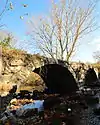 Hickory Creek Stone Arch Bridge |
April 1, 1987 (#87000526) |
Sherwood Rd. over Hickory Creek 35°28′35″N 85°50′47″W |
Marvin Chapel | |
| 9 | Marugg Company | 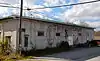 Marugg Company |
April 1, 1987 (#87000527) |
35 Depot St. 35°15′40″N 85°44′18″W |
Tracy City | |
| 10 | Monteagle Sunday School Assembly Historic District | 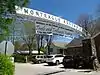 Monteagle Sunday School Assembly Historic District |
March 25, 1982 (#82003974) |
Off U.S. Route 41, U.S. Route 64, and State Route 56 35°14′38″N 85°50′14″W |
Monteagle | |
| 11 | H.B. Northcutt House | 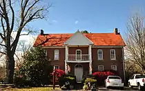 H.B. Northcutt House |
March 23, 1982 (#82003973) |
State Route 56 35°25′45″N 85°43′26″W |
Altamont | |
| 12 | Northcutts Cove Chapel | 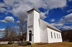 Northcutts Cove Chapel |
April 18, 1979 (#79002433) |
Southeast of Altamont 35°30′48″N 85°45′00″W |
Altamont | |
| 13 | Scott Creek Stone Arch Bridge |  Scott Creek Stone Arch Bridge |
April 1, 1987 (#87000539) |
Over Scott Creek at Flat Branch Rd. 35°18′17″N 85°42′45″W |
Coalmont | |
| 14 | Col. A.M. Shook House | 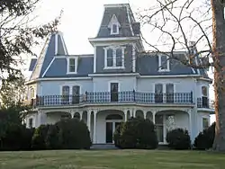 Col. A.M. Shook House |
April 1, 1987 (#87000529) |
Junction of Depot and Montgomery Sts. 35°15′31″N 85°44′26″W |
Tracy City | |
| 15 | Stagecoach Inn | 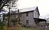 Stagecoach Inn |
April 2, 1987 (#87000524) |
Colony Rd. 35°23′58″N 85°40′02″W |
Gruetli | |
| 16 | Stagecoach Road | April 1, 1987 (#87000521) |
Savage Gulf State Natural Area northwest of State Route 108 35°26′48″N 85°36′16″W |
Beersheba Springs | ||
| 17 | Stoker-Stampfli Farm | Stoker-Stampfli Farm |
April 2, 1987 (#87000525) |
Colony Cemetery Rd. 35°23′32″N 85°38′44″W |
Gruetli | |
| 18 | Tracy City Coke Ovens | April 1, 1987 (#87000533) |
West of Hobbs Hill Rd. 35°16′34″N 85°44′03″W |
Tracy City | ||
| 19 | Frank White House |  Frank White House |
April 1, 1987 (#87000530) |
10th St. 35°15′20″N 85°44′11″W |
Tracy City | |
| 20 | Wonder Cave Historic District | April 1, 1987 (#87000520) |
Wonder Cave Rd. 35°16′24″N 85°50′55″W |
Monteagle | ||
| 21 | L.V. Woodlee House | 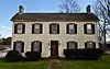 L.V. Woodlee House |
April 2, 1987 (#87000523) |
Cumberland St. 35°25′50″N 85°43′21″W |
Altamont | |
| 22 | Wrenn's Nest | March 13, 1986 (#86000399) |
Eagle Cliff Rd. 35°14′57″N 85°50′53″W |
Monteagle |
Former listings
| [3] | Name on the Register | Image | Date listed | Date removed | Location | City or town | Summary |
|---|---|---|---|---|---|---|---|
| 1 | Elkhead Stone Arch Bridge | April 19, 1978 (#78002593) | August 1, 1986 | N of Pelham |
Pelham vicinity | ||
| 2 | Grundy County Jail | June 18, 1978 (#75001756) | 1982 | Off TN 56 |
Altamont | Three-story red brick building that was a local landmark; demolished in 1982.[6] | |
| 3 | Miner's Hall | April 1, 1987 (#87000535) | May 23, 1988 | Jasper Rd. |
Tracy City | ||
| 4 | John E. Patton House | April 1, 1987 (#87000540) | November 27, 2019 | Roddy Creek Rd. 35°19′56″N 85°42′23″W |
Coalmont |
See also
| Wikimedia Commons has media related to National Register of Historic Places in Grundy County, Tennessee. |
References
- The latitude and longitude information provided in this table was derived originally from the National Register Information System, which has been found to be fairly accurate for about 99% of listings. Some locations in this table may have been corrected to current GPS standards.
- "National Register of Historic Places: Weekly List Actions". National Park Service, United States Department of the Interior. Retrieved on January 29, 2021.
- Numbers represent an alphabetical ordering by significant words. Various colorings, defined here, differentiate National Historic Landmarks and historic districts from other NRHP buildings, structures, sites or objects.
- "National Register Information System". National Register of Historic Places. National Park Service. April 24, 2008.
- The eight-digit number below each date is the number assigned to each location in the National Register Information System database, which can be viewed by clicking the number.
- https://npgallery.nps.gov/NRHP/GetAsset/NRHP/64000803_text
| Topics | |
|---|---|
| Lists by state |
|
| Lists by insular areas | |
| Lists by associated state | |
| Other areas | |
| Related | |
| |
Municipalities and communities of Grundy County, Tennessee, United States | ||
|---|---|---|
| Cities | ||
| Towns | ||
| CDP | ||
| Footnotes | ‡This populated place also has portions in an adjacent county or counties | |
| ||
This article is issued from Wikipedia. The text is licensed under Creative Commons - Attribution - Sharealike. Additional terms may apply for the media files.