National Register of Historic Places listings in Marshall County, Tennessee
This is a list of the National Register of Historic Places listings in Marshall County, Tennessee.
Location of Marshall County in Tennessee
This is intended to be a complete list of the properties and districts on the National Register of Historic Places in Marshall County, Tennessee, United States. Latitude and longitude coordinates are provided for many National Register properties and districts; these locations may be seen together in a map.[1]
There are 22 properties and districts listed on the National Register in the county.
| Anderson – Bedford – Benton – Bledsoe – Blount – Bradley – Campbell – Cannon – Carroll – Carter – Cheatham – Chester – Claiborne – Clay – Cocke – Coffee – Crockett – Cumberland – Davidson – Decatur – DeKalb – Dickson – Dyer – Fayette – Fentress – Franklin – Gibson – Giles – Grainger – Greene – Grundy – Hamblen – Hamilton – Hancock – Hardeman – Hardin – Hawkins – Haywood – Henderson – Henry – Hickman – Houston – Humphreys – Jackson – Jefferson – Johnson – Knox – Lake – Lauderdale – Lawrence – Lewis – Lincoln – Loudon – Macon – Madison – Marion – Marshall – Maury – McMinn – McNairy – Meigs – Monroe – Montgomery – Moore – Morgan – Obion – Overton – Perry – Pickett – Polk – Putnam – Rhea – Roane – Robertson – Rutherford – Scott – Sequatchie – Sevier – Shelby – Smith – Stewart – Sullivan – Sumner – Tipton – Trousdale – Unicoi – Union – Van Buren – Warren – Washington – Wayne – Weakley – White – Williamson – Wilson |
- This National Park Service list is complete through NPS recent listings posted January 29, 2021.[2]
Current listings
| [3] | Name on the Register[4] | Image | Date listed[5] | Location | City or town | Description |
|---|---|---|---|---|---|---|
| 1 | Joe Chase Adams House | 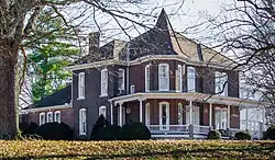 Joe Chase Adams House |
December 2, 1993 (#93001354) |
327 E. Church St. 35°26′59″N 86°47′02″W |
Lewisburg | |
| 2 | Baird-Welch House | 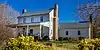 Baird-Welch House |
March 21, 1985 (#85000621) |
Water St. 35°21′43″N 86°50′18″W |
Cornersville | |
| 3 | Bear Creek Cumberland Presbyterian Church | 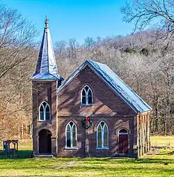 Bear Creek Cumberland Presbyterian Church |
March 28, 1985 (#85000667) |
Bear Creek Rd. 35°25′23″N 86°55′55″W |
Mooresville | |
| 4 | Belfast Railroad Depot | 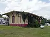 Belfast Railroad Depot |
August 9, 1984 (#84003606) |
U.S. Route 431 35°25′12″N 86°42′07″W |
Belfast | |
| 5 | Berlin Historic District | August 30, 1984 (#84003609) |
U.S. Route 431 35°31′36″N 86°49′50″W |
Berlin | ||
| 6 | Joseph Brittain House |  Joseph Brittain House |
March 17, 1997 (#97000241) |
Junction of Thick and Sweeney Rds. 35°40′44″N 86°43′45″W |
Thick | |
| 7 | Chapel Hill Cumberland Presbyterian Church | August 30, 1985 (#85001897) |
Main St. 35°37′46″N 86°41′28″W |
Chapel Hill | ||
| 8 | Confederate Cemetery Monument | July 11, 2001 (#01000731) |
Northern side of State Route 64E 35°29′54″N 86°41′53″W |
Farmington | ||
| 9 | Cornersville Methodist Episcopal Church South | 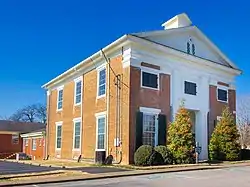 Cornersville Methodist Episcopal Church South |
April 15, 1982 (#82003991) |
100 S. Mulberry St. 35°21′43″N 86°50′29″W |
Cornersville | |
| 10 | Ewing Farm | April 5, 1984 (#84003612) |
Franklin Road 35°28′47″N 86°47′58″W |
Lewisburg | ||
| 11 | Fitzpatrick House | August 26, 1982 (#82003992) |
State Route 50A 35°26′30″N 86°54′54″W |
Mooresville | ||
| 12 | Nathan Bedford Forrest Boyhood Home | 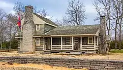 Nathan Bedford Forrest Boyhood Home |
July 13, 1977 (#77001280) |
1435 Dean Rd 35°38′25″N 86°45′02″W |
Chapel Hill | |
| 13 | Robert C. Harris House | January 27, 1983 (#83003051) |
West of S. Berlin on State Route 50 35°30′08″N 86°52′29″W |
South Berlin | ||
| 14 | Ladies Rest Room | November 29, 1995 (#95001380) |
105 1st Ave., N. 35°26′45″N 86°46′57″W |
Lewisburg | ||
| 15 | Lillard's Mill Hydroelectric Station | April 20, 1990 (#89002370) |
McLean Rd. and the Duck River 35°34′59″N 86°46′48″W |
Milltown | ||
| 16 | Palmetto Farm | March 28, 1985 (#85000675) |
State Route 64 35°29′28″N 86°39′49″W |
Bedford | Extends into Bedford County | |
| 17 | Presbyterian Church, U.S.A. | November 27, 2019 (#100004693) |
300 Water St. 35°27′04″N 86°47′25″W |
Lewisburg | ||
| 18 | Swaim House | Swaim House |
July 12, 1984 (#84003613) |
200 N. Horton Pkwy 35°37′41″N 86°41′33″W |
Chapel Hill | |
| 19 | J.C. Tate General Merchandise Store | July 12, 1978 (#78002608) |
Old Belfast Rd. 35°25′11″N 86°42′10″W |
Belfast | ||
| 20 | Valley Farm | April 5, 1984 (#84003616) |
Cornersville Rd. 35°23′28″N 86°49′11″W |
Cornersville | ||
| 21 | Verona Methodist Episcopal Church, South | November 7, 1985 (#85002755) |
Verona-Berlin Rd. 35°31′46″N 86°46′21″W |
Verona | ||
| 22 | WJJM Radio Station and Tower | July 10, 2017 (#100001304) |
344 E Church St. 35°27′01″N 86°47′01″W |
Lewisburg |
See also
| Wikimedia Commons has media related to National Register of Historic Places in Marshall County, Tennessee. |
References
- The latitude and longitude information provided in this table was derived originally from the National Register Information System, which has been found to be fairly accurate for about 99% of listings. Some locations in this table may have been corrected to current GPS standards.
- "National Register of Historic Places: Weekly List Actions". National Park Service, United States Department of the Interior. Retrieved on January 29, 2021.
- Numbers represent an alphabetical ordering by significant words. Various colorings, defined here, differentiate National Historic Landmarks and historic districts from other NRHP buildings, structures, sites or objects.
- "National Register Information System". National Register of Historic Places. National Park Service. April 24, 2008.
- The eight-digit number below each date is the number assigned to each location in the National Register Information System database, which can be viewed by clicking the number.
| Topics | |
|---|---|
| Lists by state |
|
| Lists by insular areas | |
| Lists by associated state | |
| Other areas | |
| Related | |
| |
Municipalities and communities of Marshall County, Tennessee, United States | ||
|---|---|---|
| City | Marshall County map | |
| Towns | ||
| Unincorporated communities | ||
| Ghost town | ||
| Footnotes | ‡This populated place also has portions in an adjacent county or counties | |
| ||
This article is issued from Wikipedia. The text is licensed under Creative Commons - Attribution - Sharealike. Additional terms may apply for the media files.