Bélâbre
Bélâbre is a commune in the Indre department in central France. It is the site of the Gallic city of Vosagum during the era of the Roman Empire's domination of this part of western [2] Gaul (France).
Bélâbre | |
|---|---|
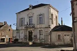 Town hall | |
.svg.png.webp) Coat of arms | |
Location of Bélâbre 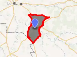
| |
 Bélâbre  Bélâbre | |
| Coordinates: 46°33′08″N 1°09′32″E | |
| Country | France |
| Region | Centre-Val de Loire |
| Department | Indre |
| Arrondissement | Le Blanc |
| Canton | Saint-Gaultier |
| Government | |
| • Mayor (2008–2014) | René Duplant |
| Area 1 | 40.14 km2 (15.50 sq mi) |
| Population (2017-01-01)[1] | 968 |
| • Density | 24/km2 (62/sq mi) |
| Time zone | UTC+01:00 (CET) |
| • Summer (DST) | UTC+02:00 (CEST) |
| INSEE/Postal code | 36016 /36370 |
| Elevation | 95–156 m (312–512 ft) (avg. 107 m or 351 ft) |
| 1 French Land Register data, which excludes lakes, ponds, glaciers > 1 km2 (0.386 sq mi or 247 acres) and river estuaries. | |
Geography
The commune is located in the parc naturel régional de la Brenne.
The river Anglin flows northwest through the commune and crosses the village.
Population
|
|
See also
References
- "Populations légales 2017". INSEE. Retrieved 6 January 2020.
- "Archived copy". Archived from the original on 2015-11-26. Retrieved 2015-11-30.CS1 maint: archived copy as title (link)
| Wikimedia Commons has media related to Bélâbre. |
| Authority control |
|
|---|
This article is issued from Wikipedia. The text is licensed under Creative Commons - Attribution - Sharealike. Additional terms may apply for the media files.