Clion, Indre
Clion is a commune in the Indre department in central France. It was known in the Roman period as Claudiomagus.[2]
Clion | |
|---|---|
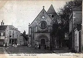 The Church of Sainte-Colombe in Clion, in 1900 | |
Location of Clion 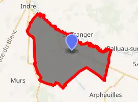
| |
 Clion  Clion | |
| Coordinates: 46°56′32″N 1°14′00″E | |
| Country | France |
| Region | Centre-Val de Loire |
| Department | Indre |
| Arrondissement | Châteauroux |
| Canton | Buzançais |
| Government | |
| • Mayor (2008–2014) | Williams Lauerière |
| Area 1 | 33.53 km2 (12.95 sq mi) |
| Population (2017-01-01)[1] | 1,023 |
| • Density | 31/km2 (79/sq mi) |
| Time zone | UTC+01:00 (CET) |
| • Summer (DST) | UTC+02:00 (CEST) |
| INSEE/Postal code | 36055 /36700 |
| Elevation | 86–153 m (282–502 ft) (avg. 108 m or 354 ft) |
| 1 French Land Register data, which excludes lakes, ponds, glaciers > 1 km2 (0.386 sq mi or 247 acres) and river estuaries. | |
It is situated 38 km or 24 miles northwest of Châteauroux, the nearest large city. The Indre and Ozance rivers flow through the commune.
Population
| Year | Pop. | ±% |
|---|---|---|
| 1793 | 1,191 | — |
| 1800 | 1,035 | −13.1% |
| 1806 | 1,340 | +29.5% |
| 1821 | 1,481 | +10.5% |
| 1831 | 1,482 | +0.1% |
| 1836 | 1,602 | +8.1% |
| 1841 | 1,651 | +3.1% |
| 1846 | 1,713 | +3.8% |
| 1851 | 1,789 | +4.4% |
| 1856 | 1,867 | +4.4% |
| 1861 | 1,854 | −0.7% |
| 1866 | 1,940 | +4.6% |
| 1872 | 1,907 | −1.7% |
| 1876 | 1,913 | +0.3% |
| 1881 | 1,953 | +2.1% |
| 1886 | 1,986 | +1.7% |
| 1891 | 1,917 | −3.5% |
| 1896 | 1,968 | +2.7% |
| 1901 | 1,915 | −2.7% |
| 1906 | 1,973 | +3.0% |
| 1911 | 1,957 | −0.8% |
| 1921 | 1,804 | −7.8% |
| 1926 | 1,694 | −6.1% |
| 1931 | 1,649 | −2.7% |
| 1936 | 1,670 | +1.3% |
| 1946 | 1,676 | +0.4% |
| 1954 | 1,749 | +4.4% |
| 1962 | 1,671 | −4.5% |
| 1968 | 1,561 | −6.6% |
| 1975 | 1,448 | −7.2% |
| 1982 | 1,387 | −4.2% |
| 1990 | 1,243 | −10.4% |
| 1999 | 1,155 | −7.1% |
| 2009 | 1,123 | −2.8% |
Residents are known as Clionnais.[3]
See also
References
- "Populations légales 2017". INSEE. Retrieved 6 January 2020.
- Mathisen, R., H. Sivan. "Places: 138299 (Claudiomagus)". Pleiades. Retrieved 2 January 2020.CS1 maint: multiple names: authors list (link)
- "Mairie de Clion, la Commune de Clion et son village (36700) (Indre)". Annuaire-Mairie. Retrieved 20 April 2018.
| Wikimedia Commons has media related to Clion (Indre). |
| Authority control |
|
|---|
This article is issued from Wikipedia. The text is licensed under Creative Commons - Attribution - Sharealike. Additional terms may apply for the media files.