Pouligny-Saint-Pierre
Pouligny-Saint-Pierre is a commune in the Indre department in central France.
Pouligny-Saint-Pierre | |
|---|---|
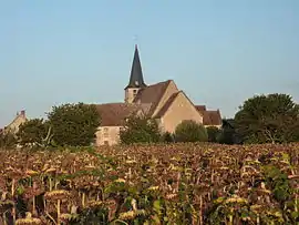 The church of Saint-Pierre, in Pouligny-Saint-Pierre | |
Location of Pouligny-Saint-Pierre 
| |
 Pouligny-Saint-Pierre  Pouligny-Saint-Pierre | |
| Coordinates: 46°40′54″N 1°02′24″E | |
| Country | France |
| Region | Centre-Val de Loire |
| Department | Indre |
| Arrondissement | Le Blanc |
| Canton | Le Blanc |
| Intercommunality | Brenne Val de Creuse |
| Government | |
| • Mayor (2008–2014) | Roland Caillaud |
| Area 1 | 47.45 km2 (18.32 sq mi) |
| Population (2017-01-01)[1] | 1,069 |
| • Density | 23/km2 (58/sq mi) |
| Time zone | UTC+01:00 (CET) |
| • Summer (DST) | UTC+02:00 (CEST) |
| INSEE/Postal code | 36165 /36300 |
| Elevation | 72–143 m (236–469 ft) (avg. 113 m or 371 ft) |
| 1 French Land Register data, which excludes lakes, ponds, glaciers > 1 km2 (0.386 sq mi or 247 acres) and river estuaries. | |
The commune is known internationally for its goat's cheese, Pouligny-Saint-Pierre, that was first made in the village in the 19th century.
Geography
The commune is located in the parc naturel régional de la Brenne.
Population
| Year | Pop. | ±% |
|---|---|---|
| 1793 | 2,553 | — |
| 1800 | 2,041 | −20.1% |
| 1806 | 2,031 | −0.5% |
| 1821 | 1,956 | −3.7% |
| 1831 | 2,049 | +4.8% |
| 1836 | 2,158 | +5.3% |
| 1841 | 2,048 | −5.1% |
| 1846 | 2,097 | +2.4% |
| 1851 | 2,155 | +2.8% |
| 1856 | 2,167 | +0.6% |
| 1861 | 2,120 | −2.2% |
| 1866 | 2,125 | +0.2% |
| 1872 | 1,947 | −8.4% |
| 1876 | 1,898 | −2.5% |
| 1881 | 1,863 | −1.8% |
| 1886 | 1,885 | +1.2% |
| 1891 | 1,829 | −3.0% |
| 1896 | 1,683 | −8.0% |
| 1901 | 1,714 | +1.8% |
| 1906 | 1,686 | −1.6% |
| 1911 | 1,625 | −3.6% |
| 1921 | 1,424 | −12.4% |
| 1926 | 1,415 | −0.6% |
| 1931 | 1,360 | −3.9% |
| 1936 | 1,309 | −3.7% |
| 1946 | 1,244 | −5.0% |
| 1954 | 1,191 | −4.3% |
| 1962 | 1,120 | −6.0% |
| 1968 | 1,018 | −9.1% |
| 1975 | 972 | −4.5% |
| 1982 | 982 | +1.0% |
| 1990 | 962 | −2.0% |
| 1999 | 978 | +1.7% |
| 2009 | 1,050 | +7.4% |
See also
References
- "Populations légales 2017". INSEE. Retrieved 6 January 2020.
| Wikimedia Commons has media related to Pouligny-Saint-Pierre. |
| Authority control |
|---|
This article is issued from Wikipedia. The text is licensed under Creative Commons - Attribution - Sharealike. Additional terms may apply for the media files.