Lureuil
Lureuil is a commune in the Indre department in central France.
Lureuil | |
|---|---|
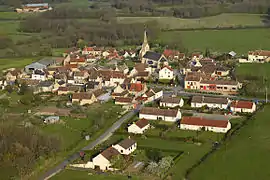 The church and surrounding buildings in Lureuil | |
Location of Lureuil 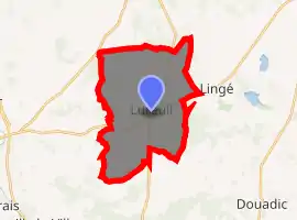
| |
 Lureuil  Lureuil | |
| Coordinates: 46°44′41″N 1°02′36″E | |
| Country | France |
| Region | Centre-Val de Loire |
| Department | Indre |
| Arrondissement | Le Blanc |
| Canton | Le Blanc |
| Government | |
| • Mayor (2008–2014) | Gérard Blondeau |
| Area 1 | 22.04 km2 (8.51 sq mi) |
| Population (2017-01-01)[1] | 263 |
| • Density | 12/km2 (31/sq mi) |
| Time zone | UTC+01:00 (CET) |
| • Summer (DST) | UTC+02:00 (CEST) |
| INSEE/Postal code | 36105 /36220 |
| Elevation | 90–151 m (295–495 ft) (avg. 152 m or 499 ft) |
| 1 French Land Register data, which excludes lakes, ponds, glaciers > 1 km2 (0.386 sq mi or 247 acres) and river estuaries. | |
Geography
The commune is located in the parc naturel régional de la Brenne.
Population
|
|
See also
References
- "Populations légales 2017". INSEE. Retrieved 6 January 2020.
| Wikimedia Commons has media related to Lureuil. |
| Authority control |
|---|
This article is issued from Wikipedia. The text is licensed under Creative Commons - Attribution - Sharealike. Additional terms may apply for the media files.
