Le Pêchereau
Le Pêchereau is a commune in the Indre department in central France.
Le Pêchereau | |
|---|---|
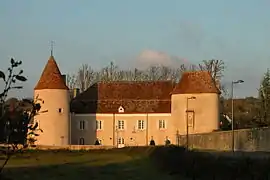 The Château du Courbat, the town hall in Le Pêchereau | |
.svg.png.webp) Coat of arms | |
Location of Le Pêchereau 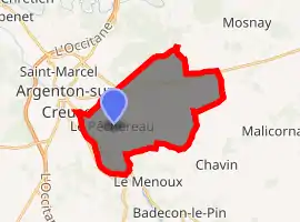
| |
 Le Pêchereau  Le Pêchereau | |
| Coordinates: 46°34′44″N 1°32′54″E | |
| Country | France |
| Region | Centre-Val de Loire |
| Department | Indre |
| Arrondissement | Châteauroux |
| Canton | Argenton-sur-Creuse |
| Government | |
| • Mayor (2008–2014) | Jean-Claude Andrieux |
| Area 1 | 20.94 km2 (8.08 sq mi) |
| Population (2017-01-01)[1] | 1,863 |
| • Density | 89/km2 (230/sq mi) |
| Time zone | UTC+01:00 (CET) |
| • Summer (DST) | UTC+02:00 (CEST) |
| INSEE/Postal code | 36154 /36200 |
| Elevation | 103–256 m (338–840 ft) (avg. 110 m or 360 ft) |
| 1 French Land Register data, which excludes lakes, ponds, glaciers > 1 km2 (0.386 sq mi or 247 acres) and river estuaries. | |
Population
|
|
See also
References
- "Populations légales 2017". INSEE. Retrieved 6 January 2020.
| Wikimedia Commons has media related to Le Pêchereau. |
| Authority control |
|
|---|
This article is issued from Wikipedia. The text is licensed under Creative Commons - Attribution - Sharealike. Additional terms may apply for the media files.