Saint-Genou
Saint-Genou is a commune in the Indre department in central France.
Saint-Genou | |
|---|---|
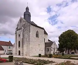 The Abbey of Saint-Genou, in Saint-Genou | |
Location of Saint-Genou 
| |
 Saint-Genou  Saint-Genou | |
| Coordinates: 46°55′49″N 1°20′20″E | |
| Country | France |
| Region | Centre-Val de Loire |
| Department | Indre |
| Arrondissement | Châteauroux |
| Canton | Buzançais |
| Intercommunality | Val de l'Indre-Brenne |
| Government | |
| • Mayor (2008–2014) | Gilbert Gaulué |
| Area 1 | 24.41 km2 (9.42 sq mi) |
| Population (2017-01-01)[1] | 971 |
| • Density | 40/km2 (100/sq mi) |
| Time zone | UTC+01:00 (CET) |
| • Summer (DST) | UTC+02:00 (CEST) |
| INSEE/Postal code | 36194 /36500 |
| Elevation | 97–167 m (318–548 ft) (avg. 105 m or 344 ft) |
| 1 French Land Register data, which excludes lakes, ponds, glaciers > 1 km2 (0.386 sq mi or 247 acres) and river estuaries. | |
Population
| Year | Pop. | ±% |
|---|---|---|
| 1793 | 938 | — |
| 1800 | 824 | −12.2% |
| 1806 | 887 | +7.6% |
| 1821 | 974 | +9.8% |
| 1831 | 1,014 | +4.1% |
| 1836 | 1,014 | +0.0% |
| 1841 | 935 | −7.8% |
| 1846 | 1,040 | +11.2% |
| 1851 | 1,074 | +3.3% |
| 1856 | 1,241 | +15.5% |
| 1861 | 1,171 | −5.6% |
| 1866 | 1,226 | +4.7% |
| 1872 | 1,247 | +1.7% |
| 1876 | 1,251 | +0.3% |
| 1881 | 1,168 | −6.6% |
| 1886 | 1,264 | +8.2% |
| 1891 | 1,317 | +4.2% |
| 1896 | 1,379 | +4.7% |
| 1901 | 1,500 | +8.8% |
| 1906 | 1,489 | −0.7% |
| 1911 | 1,428 | −4.1% |
| 1921 | 1,283 | −10.2% |
| 1926 | 1,272 | −0.9% |
| 1931 | 1,387 | +9.0% |
| 1936 | 1,528 | +10.2% |
| 1946 | 1,359 | −11.1% |
| 1954 | 1,479 | +8.8% |
| 1962 | 1,417 | −4.2% |
| 1968 | 1,290 | −9.0% |
| 1975 | 1,205 | −6.6% |
| 1982 | 1,101 | −8.6% |
| 1990 | 1,065 | −3.3% |
| 1999 | 1,038 | −2.5% |
| 2006 | 989 | −4.7% |
| 2009 | 1,025 | +3.6% |
See also
References
- "Populations légales 2017". INSEE. Retrieved 6 January 2020.
| Wikimedia Commons has media related to Saint-Genou. |
| Authority control |
|---|
This article is issued from Wikipedia. The text is licensed under Creative Commons - Attribution - Sharealike. Additional terms may apply for the media files.
