Saint-Maur, Indre
Saint-Maur is a commune in the Indre department in central France. On 1 January 2016, the former commune of Villers-les-Ormes was merged into Saint-Maur.[2]
Saint-Maur | |
|---|---|
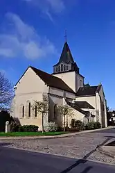 The church in Saint-Maur | |
Location of Saint-Maur 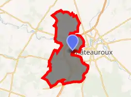
| |
 Saint-Maur  Saint-Maur | |
| Coordinates: 46°48′27″N 1°38′24″E | |
| Country | France |
| Region | Centre-Val de Loire |
| Department | Indre |
| Arrondissement | Châteauroux |
| Canton | Buzançais, Levroux |
| Intercommunality | Castelroussine |
| Government | |
| • Mayor (2008–2014) | François Jolivet |
| Area 1 | 87.91 km2 (33.94 sq mi) |
| Population (2017-01-01)[1] | 3,642 |
| • Density | 41/km2 (110/sq mi) |
| Time zone | UTC+01:00 (CET) |
| • Summer (DST) | UTC+02:00 (CEST) |
| INSEE/Postal code | 36202 /36250 |
| Elevation | 127–184 m (417–604 ft) (avg. 154 m or 505 ft) |
| 1 French Land Register data, which excludes lakes, ponds, glaciers > 1 km2 (0.386 sq mi or 247 acres) and river estuaries. | |
Population
| Year | Pop. | ±% |
|---|---|---|
| 1793 | 1,333 | — |
| 1800 | 1,559 | +17.0% |
| 1806 | 1,054 | −32.4% |
| 1821 | 1,252 | +18.8% |
| 1831 | 1,251 | −0.1% |
| 1836 | 1,393 | +11.4% |
| 1841 | 1,322 | −5.1% |
| 1846 | 1,299 | −1.7% |
| 1851 | 1,339 | +3.1% |
| 1856 | 1,256 | −6.2% |
| 1861 | 1,352 | +7.6% |
| 1866 | 1,410 | +4.3% |
| 1872 | 1,399 | −0.8% |
| 1876 | 1,400 | +0.1% |
| 1881 | 1,483 | +5.9% |
| 1886 | 1,491 | +0.5% |
| 1891 | 1,448 | −2.9% |
| 1896 | 1,495 | +3.2% |
| 1901 | 1,458 | −2.5% |
| 1906 | 1,506 | +3.3% |
| 1911 | 1,559 | +3.5% |
| 1921 | 1,448 | −7.1% |
| 1926 | 1,445 | −0.2% |
| 1931 | 1,384 | −4.2% |
| 1936 | 1,364 | −1.4% |
| 1946 | 1,576 | +15.5% |
| 1954 | 1,606 | +1.9% |
| 1962 | 1,653 | +2.9% |
| 1968 | 1,890 | +14.3% |
| 1975 | 2,629 | +39.1% |
| 1982 | 3,504 | +33.3% |
| 1990 | 3,646 | +4.1% |
| 1999 | 3,340 | −8.4% |
| 2006 | 3,399 | +1.8% |
| 2009 | 3,366 | −1.0% |
See also
References
- "Populations légales 2017". INSEE. Retrieved 6 January 2020.
- Arrêté préfectoral 11 December 2015 (in French)
| Wikimedia Commons has media related to Saint-Maur (Indre). |
This article is issued from Wikipedia. The text is licensed under Creative Commons - Attribution - Sharealike. Additional terms may apply for the media files.