Niherne
Niherne is a commune in the Indre department in central France.
Niherne | |
|---|---|
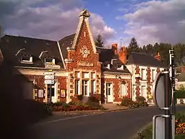 The town hall in Niherne | |
Location of Niherne 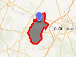
| |
 Niherne  Niherne | |
| Coordinates: 46°49′45″N 1°33′55″E | |
| Country | France |
| Region | Centre-Val de Loire |
| Department | Indre |
| Arrondissement | Châteauroux |
| Canton | Buzançais |
| Intercommunality | Val de l'Indre-Brenne |
| Government | |
| • Mayor (2008–2014) | Alain Lavaud |
| Area 1 | 42.87 km2 (16.55 sq mi) |
| Population (2017-01-01)[1] | 1,586 |
| • Density | 37/km2 (96/sq mi) |
| Time zone | UTC+01:00 (CET) |
| • Summer (DST) | UTC+02:00 (CEST) |
| INSEE/Postal code | 36142 /36250 |
| Elevation | 122–163 m (400–535 ft) (avg. 130 m or 430 ft) |
| 1 French Land Register data, which excludes lakes, ponds, glaciers > 1 km2 (0.386 sq mi or 247 acres) and river estuaries. | |
Population
| Year | Pop. | ±% |
|---|---|---|
| 1793 | 960 | — |
| 1800 | 1,002 | +4.4% |
| 1806 | 1,028 | +2.6% |
| 1821 | 1,164 | +13.2% |
| 1831 | 1,230 | +5.7% |
| 1836 | 1,241 | +0.9% |
| 1841 | 1,165 | −6.1% |
| 1846 | 1,175 | +0.9% |
| 1851 | 1,192 | +1.4% |
| 1856 | 1,157 | −2.9% |
| 1861 | 1,150 | −0.6% |
| 1866 | 1,181 | +2.7% |
| 1872 | 1,195 | +1.2% |
| 1876 | 1,201 | +0.5% |
| 1881 | 1,233 | +2.7% |
| 1886 | 1,251 | +1.5% |
| 1891 | 1,306 | +4.4% |
| 1896 | 1,373 | +5.1% |
| 1901 | 1,304 | −5.0% |
| 1906 | 1,314 | +0.8% |
| 1911 | 1,341 | +2.1% |
| 1921 | 1,156 | −13.8% |
| 1926 | 1,186 | +2.6% |
| 1931 | 1,154 | −2.7% |
| 1936 | 1,069 | −7.4% |
| 1946 | 1,139 | +6.5% |
| 1954 | 1,174 | +3.1% |
| 1962 | 1,135 | −3.3% |
| 1968 | 1,091 | −3.9% |
| 1975 | 1,103 | +1.1% |
| 1982 | 1,319 | +19.6% |
| 1990 | 1,504 | +14.0% |
| 1999 | 1,482 | −1.5% |
| 2009 | 1,554 | +4.9% |
See also
References
- "Populations légales 2017". INSEE. Retrieved 6 January 2020.
| Wikimedia Commons has media related to Niherne. |
| Authority control |
|---|
This article is issued from Wikipedia. The text is licensed under Creative Commons - Attribution - Sharealike. Additional terms may apply for the media files.