Châtillon-sur-Indre
Châtillon-sur-Indre is a commune in the Indre department in central France.
Châtillon-sur-Indre | |
|---|---|
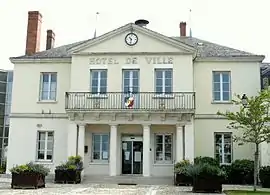 Town hall | |
.svg.png.webp) Coat of arms | |
Location of Châtillon-sur-Indre 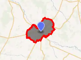
| |
 Châtillon-sur-Indre  Châtillon-sur-Indre | |
| Coordinates: 46°59′19″N 1°10′28″E | |
| Country | France |
| Region | Centre-Val de Loire |
| Department | Indre |
| Arrondissement | Châteauroux |
| Canton | Buzançais |
| Government | |
| • Mayor (2008–2014) | Michel Hétroy |
| Area 1 | 45.3 km2 (17.5 sq mi) |
| Population (2017-01-01)[1] | 2,567 |
| • Density | 57/km2 (150/sq mi) |
| Time zone | UTC+01:00 (CET) |
| • Summer (DST) | UTC+02:00 (CEST) |
| INSEE/Postal code | 36045 /36700 |
| Elevation | 82–148 m (269–486 ft) (avg. 88 m or 289 ft) |
| 1 French Land Register data, which excludes lakes, ponds, glaciers > 1 km2 (0.386 sq mi or 247 acres) and river estuaries. | |
Population
| Year | Pop. | ±% |
|---|---|---|
| 1793 | 2,800 | — |
| 1800 | 2,627 | −6.2% |
| 1806 | 2,758 | +5.0% |
| 1821 | 2,952 | +7.0% |
| 1831 | 3,339 | +13.1% |
| 1836 | 3,312 | −0.8% |
| 1841 | 3,575 | +7.9% |
| 1846 | 3,676 | +2.8% |
| 1851 | 3,925 | +6.8% |
| 1856 | 3,926 | +0.0% |
| 1861 | 3,869 | −1.5% |
| 1866 | 3,875 | +0.2% |
| 1872 | 3,643 | −6.0% |
| 1876 | 3,455 | −5.2% |
| 1881 | 3,436 | −0.5% |
| 1886 | 3,500 | +1.9% |
| 1891 | 3,555 | +1.6% |
| 1896 | 3,628 | +2.1% |
| 1901 | 3,662 | +0.9% |
| 1906 | 3,542 | −3.3% |
| 1911 | 3,621 | +2.2% |
| 1921 | 3,371 | −6.9% |
| 1926 | 3,416 | +1.3% |
| 1931 | 3,335 | −2.4% |
| 1936 | 3,376 | +1.2% |
| 1946 | 3,599 | +6.6% |
| 1954 | 3,404 | −5.4% |
| 1962 | 3,479 | +2.2% |
| 1968 | 3,658 | +5.1% |
| 1975 | 3,624 | −0.9% |
| 1982 | 3,526 | −2.7% |
| 1990 | 3,262 | −7.5% |
| 1999 | 3,120 | −4.4% |
| 2009 | 2,833 | −9.2% |
See also
References
- "Populations légales 2017". INSEE. Retrieved 6 January 2020.
| Wikimedia Commons has media related to Châtillon-sur-Indre. |
| Authority control |
|---|
This article is issued from Wikipedia. The text is licensed under Creative Commons - Attribution - Sharealike. Additional terms may apply for the media files.